
Αρχείο:Mapa Ilustrado de la Republica Mexicana Publicado Por Margaret M. Crane Eugenio Fischgrund.jpg

Εικόνα σε υψηλότερη ανάλυση (3.300 × 2.092 εικονοστοιχεία, μέγεθος αρχείου: 1,97 MB, τύπος MIME: image/jpeg)
|
|
Αυτό το αρχείο και η περιγραφή του προέρχονται από το Wikimedia Commons. Οι πληροφορίες από την σελίδα περιγραφής του εκεί εμφανίζονται παρακάτω. |
Σύνοψη
| Περιγραφή |
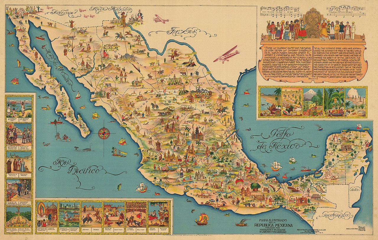
English: By: Miguel Gómez Medina
Date: 1930s (circa) Mexico Dimensions: 19.75 x 23 inches (50.2 x 58.4 cm) This is an exuberant 1930s pictorial map of Mexico designed to entice tourists to explore the many natural, historic, and cultural attractions of the country. The map was created by Miguel G. Medina, and published by Margaret M. Crane & Eugenio Fischgrund. This pictorial map of Mexico is divided by states with railroad lines extending across the country in all directions. Traditional cartographic elements are replaced by imagery of various locals using colors that allow them to blend in and out from one another. In the lower right corner, inset images depict the history of Mexico as well as Mexican customs and traditions. Such insets include the Founding of Mexico in 1325, Conquest of Mexico by Cortes in 1531, Independence of Mexico in September 16, 1810, a Rodeo, Cock-Fight, Bull Fight, and the National Dance, to name a few. A large inset fills the Gulf of Mexico and features the chorus of the national anthem of Mexico, numerous figures in indigenous garb, and a quote from the beginning of the volume on Mexico from William H. Prescott's historical series "The Nations of the World." The map was created by Miguel Gomez Medina and was given to tourists at various hotels and restaurants in Mexico City. Several versions of this map were published: larger versions in both English and Spanish and a smaller version that appeared several years later. This is the large Spanish version, with the addition of 6 planes added just across the border in the United States. |
| Ημερομηνία | δεκαετία του 1930 |
| Πηγή | Έργο αυτού που το ανεβάζει |
| Δημιουργός | New World Cartographic |
Αδειοδότηση
- Είστε ελεύθερος:
- να μοιραστείτε – να αντιγράψετε, διανέμετε και να μεταδώσετε το έργο
- να διασκευάσετε – να τροποποιήσετε το έργο
- Υπό τις ακόλουθες προϋποθέσεις:
- αναφορά προέλευσης – Θα πρέπει να κάνετε κατάλληλη αναφορά, να παρέχετε σύνδεσμο για την άδεια και να επισημάνετε εάν έγιναν αλλαγές. Μπορείτε να το κάνετε με οποιοδήποτε αιτιολογήσιμο λόγο, χωρίς όμως να εννοείται με οποιονδήποτε τρόπο ότι εγκρίνουν εσάς ή τη χρήση του έργου από εσάς.
- παρόμοια διανομή – Εάν αλλάξετε, τροποποιήσετε ή δημιουργήσετε πάνω στο έργο αυτό, μπορείτε να διανείμετε αυτό που θα προκύψει μόνο υπό τους όρους της ίδιας ή συμβατής άδειας με το πρωτότυπο.
Ιστορικό αρχείου
Κλικάρετε σε μια ημερομηνία/ώρα για να δείτε το αρχείο όπως εμφανιζόταν εκείνη τη στιγμή.
| Ώρα/Ημερομ. | Μικρογραφία | Διαστάσεις | Χρήστης | Σχόλια | |
|---|---|---|---|---|---|
| τελευταία | 17:21, 1 Ιουλίου 2020 | | 3.300 × 2.092 (1,97 MB) | New World Cartographic | Uploaded own work with UploadWizard |
Συνδέσεις αρχείου
Τα παρακάτω λήμματα συνδέουν σε αυτό το αρχείο:
Καθολική χρήση αρχείου
Τα ακόλουθα άλλα wiki χρησιμοποιούν αυτό το αρχείο:
- Χρήση σε es.wikipedia.org