
Αρχείο:Jerusalem-barrier June 2007-OCHAoPt.jpeg

Εικόνα σε υψηλότερη ανάλυση (1.159 × 1.092 εικονοστοιχεία, μέγεθος αρχείου: 190 KB, τύπος MIME: image/jpeg)
|
|
Αυτό το αρχείο και η περιγραφή του προέρχονται από το Wikimedia Commons. Οι πληροφορίες από την σελίδα περιγραφής του εκεί εμφανίζονται παρακάτω. |
Σύνοψη
| Περιγραφή |
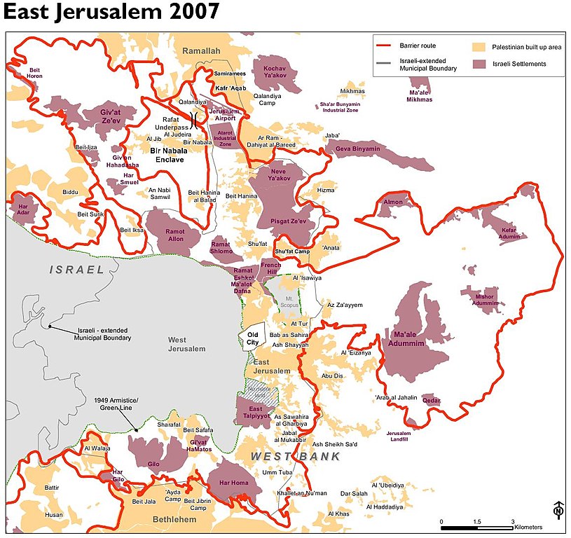
English: Jerusalem barrier, update June 2007. Planned route, including parts at the time not yet realized. From: The Humanitarian Impact of the West Bank Barrier on Palestinian Communities: East Jerusalem |
| Ημερομηνία | |
| Πηγή | http://unispal.un.org/pdfs/HI_Barrier_EJerusalem.pdf |
| Δημιουργός | UN OCHA oPt |
Αδειοδότηση
| This image is a map derived from a United Nations map.
Unless stated otherwise, UN maps are to be considered in the public domain. This applies worldwide. UN maps are, in principle, open source material and you can use them in your work or for making your own map. UN requests however that you delete the UN name, logo and reference number upon any modification to the map. Content of your map will be your responsibility. You can state in your publication, if you wish, something like: based on UN map … (map name, map number, revision number and date). See: Geospatial Information Section. And: Geospatial, location data for a better world. |
 |
Ιστορικό αρχείου
Κλικάρετε σε μια ημερομηνία/ώρα για να δείτε το αρχείο όπως εμφανιζόταν εκείνη τη στιγμή.
| Ώρα/Ημερομ. | Μικρογραφία | Διαστάσεις | Χρήστης | Σχόλια | |
|---|---|---|---|---|---|
| τελευταία | 09:46, 2 Ιουλίου 2013 | | 1.159 × 1.092 (190 KB) | Wickey-nl | User created page with UploadWizard |
Συνδέσεις αρχείου
Τα παρακάτω λήμματα συνδέουν σε αυτό το αρχείο:
Καθολική χρήση αρχείου
Τα ακόλουθα άλλα wiki χρησιμοποιούν αυτό το αρχείο:
- Χρήση σε bn.wikipedia.org
- Χρήση σε en.wikipedia.org
- Χρήση σε eo.wikipedia.org
- Χρήση σε fr.wikipedia.org
- Χρήση σε fy.wikipedia.org
- Χρήση σε nl.wikipedia.org
- Χρήση σε pt.wikipedia.org
- Χρήση σε ru.wikipedia.org
- Χρήση σε tr.wikipedia.org
- Χρήση σε uk.wikipedia.org
- Χρήση σε zh.wikipedia.org