
Αρχείο:Ionia, Asia Minor Map, Classical Atlas, 1886, Keith Johnston.jpg
Εικόνα σε υψηλότερη ανάλυση (805 × 978 εικονοστοιχεία, μέγεθος αρχείου: 262 KB, τύπος MIME: image/jpeg)
|
|
Αυτό το αρχείο και η περιγραφή του προέρχονται από το Wikimedia Commons. Οι πληροφορίες από την σελίδα περιγραφής του εκεί εμφανίζονται παρακάτω. |
| Περιγραφή |
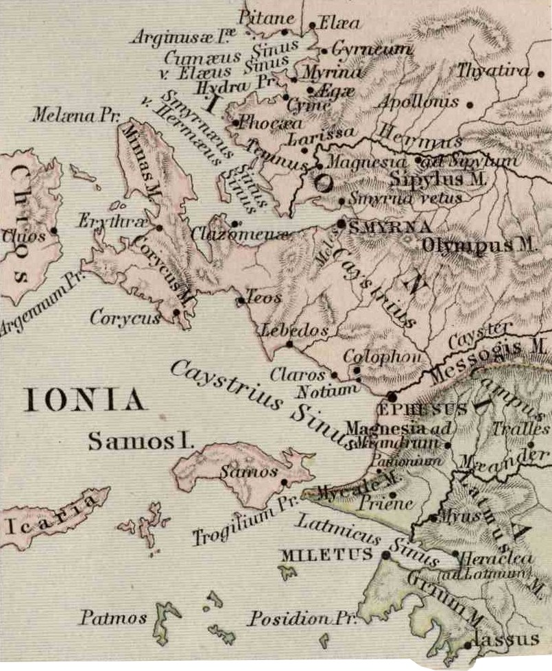
English: Asia Minor. Including Pontus, Cappadocia, Cilicia, Pisidia, Lycia, Caria, Lydia, Mysia, Bithynia, Paphlagonia, Phrygia, and Crete. "These color maps are 11" x 13.5" when printed at 300dpi. They were copied from an original 1886 Ginn & Company Classical Atlas designed by mapmaker Keith Johnston. These maps are completely Public Domain and can be used absolutely without restriction or even sold commercially without my permission. (There is slight distortion caused by the age of the original and merging the scans (two scans per map)" Information from http://www.snible.org/greek/ |
| Ημερομηνία | (UTC) |
| Πηγή | |
| Δημιουργός |
|
| Αυτή είναι μία ρετουσαρισμένη εικόνα, που σημαίνει ότι έχει μεταβληθεί ψηφιακά από την αρχική της έκδοση. Τροποποιήσεις: Cut out inset of Ionia. Η πρωτότυπη μπορεί να βρεθεί εδώ: Asia Minor Map, Classical Atlas, 1886, Keith Johnston.jpg. Οι τροποποιήσεις έγιναν από τον Jssfrk.
|
|
Αυτό το έργο είναι κοινό κτήμα στη χώρα προέλευσής του και άλλες χώρες και περιοχές όπου η διάρκεια πνευματικών δικαιωμάτων είναι όσο η ζωή του δημιουργού και μέχρι 70 χρόνια μετά ή λιγότερο.
| |
| Αυτό το αρχείο έχει χαρακτηριστεί ως απαλλαγμένο από γνωστούς περιορισμούς βάσει της νομοθεσίας περί πνευματικής ιδιοκτησίας, περιλαμβανομένων όλων των συναφών και συγγενικών δικαιωμάτων. | |
Καταγραφές ανεβασμάτων πρωτότυπου αρχείου
This image is a derivative work of the following images:
- File:Asia_Minor_Map,_Classical_Atlas,_1886,_Keith_Johnston.jpg licensed with PD-old
- 2009-12-03T21:05:42Z Jssfrk 3669x2824 (938691 Bytes) {{Information |Description={{en|1=Asia Minor. Including Pontus, Cappadocia, Cilicia, Pisidia, Lycia, Caria, Lydia, Mysia, Bithynia, Paphlagonia, Phrygia, and Crete. "These color maps are 11" x 13.5" when printed at 300dpi. T
Uploaded with derivativeFX
Ιστορικό αρχείου
Κλικάρετε σε μια ημερομηνία/ώρα για να δείτε το αρχείο όπως εμφανιζόταν εκείνη τη στιγμή.
| Ώρα/Ημερομ. | Μικρογραφία | Διαστάσεις | Χρήστης | Σχόλια | |
|---|---|---|---|---|---|
| τελευταία | 02:18, 13 Φεβρουαρίου 2010 | | 805 × 978 (262 KB) | Anonimosanhueza | borders removed |
| 07:22, 4 Δεκεμβρίου 2009 |  | 834 × 991 (288 KB) | Jssfrk | {{Information |Description={{en|1=Asia Minor. Including Pontus, Cappadocia, Cilicia, Pisidia, Lycia, Caria, Lydia, Mysia, Bithynia, Paphlagonia, Phrygia, and Crete. "These color maps are 11" x 13.5" when printed at 300dpi. They were copied from an origin |
Συνδέσεις αρχείου
Τα παρακάτω λήμματα συνδέουν σε αυτό το αρχείο:
Καθολική χρήση αρχείου
Τα ακόλουθα άλλα wiki χρησιμοποιούν αυτό το αρχείο:
- Χρήση σε arz.wikipedia.org
- Χρήση σε ca.wikipedia.org
- Χρήση σε cs.wikipedia.org
- Χρήση σε de.wikipedia.org
- Χρήση σε en.wikipedia.org
- Colophon (city)
- Myus
- Leucae (Ionia)
- Pteleum (Ionia)
- Sidussa
- User:Ryanmhorne/pleiades List
- Panormus (Ionia)
- Polichne (Ionia)
- Polichna (Ionia)
- Phoenicus (Ionia)
- Neapolis (Ionia)
- Leuconia (Ionia)
- Teichiussa
- Helos (Ionia)
- Erythras (Ionia)
- Airai (Ionia)
- Glauke (Ionia)
- Heracleium (Ionia)
- Thebes (Ionia)
- Skolopoeis
- Naulochus (Ionia)
- Ortygia (Ionia)
- Sillyos
- Achilleion (Ionia)
- Corycus (Ionia)
- Dios Hieron (Ionia)
- Larisa (Ionia)
- Dascylium (Ionia)
- Daphnus (Ionia)
- Template:AncientIonia-geo-stub
- Χρήση σε eu.wikipedia.org
- Χρήση σε fa.wikipedia.org
- Χρήση σε fr.wikipedia.org
- Χρήση σε he.wikipedia.org
- Χρήση σε id.wikipedia.org
- Χρήση σε it.wikipedia.org
- Χρήση σε ja.wikipedia.org
- Χρήση σε ka.wikipedia.org
- Χρήση σε la.wikipedia.org
- Χρήση σε pt.wikipedia.org
- Χρήση σε sv.wikipedia.org
Δείτε περισσότερη καθολική χρήση αυτού του αρχείου.