
Αρχείο:Syrian, Iraqi, and Lebanese insurgencies.png

Εικόνα σε υψηλότερη ανάλυση (4.509 × 3.449 εικονοστοιχεία, μέγεθος αρχείου: 1,74 MB, τύπος MIME: image/png)
|
|
Αυτό το αρχείο και η περιγραφή του προέρχονται από το Wikimedia Commons. Οι πληροφορίες από την σελίδα περιγραφής του εκεί εμφανίζονται παρακάτω. |
Σύνοψη

|
This file may be updated to reflect new information. If you wish to use a specific version of the file without new updates being mirrored, please upload the required version as a separate file. |
| Περιγραφή |
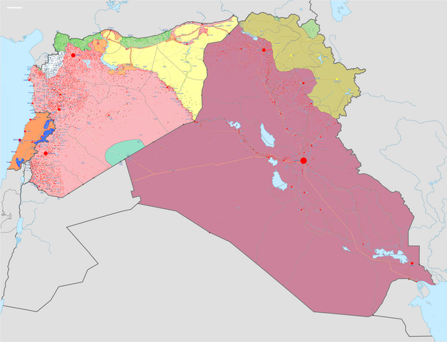
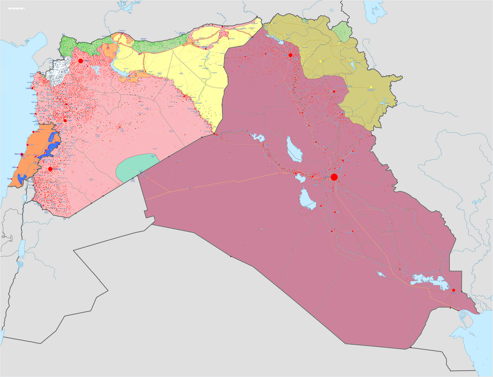
Map of the Syrian Civil War, the Iraq Civil War (2014–present), and the Lebanese insurgency. For previous revisions of the battle map (not including Lebanon) before June 2015, see File:Syria and Iraq 2014-onward War map.png. After updating this map, please also update the date(s) at w:Module:Iraq Syria map date, used to denote the date in articles. Areas under joint SDF-SAA control
In the respective colours: |
||||
| Ημερομηνία | |||||
| Πηγή |
Έργο αυτού που το ανεβάζει w:en:Template:Syrian, Iraqi, and Lebanese insurgencies detailed map |
||||
| Δημιουργός | BlueHypercane761 | ||||
| άλλες εκδόσεις |
|


.png)


.svg)


.svg)

.svg)


_Territory_Change_2014-2016.gif)

_(within_Northern_Syria).svg)


.png)
.svg)


_map.png)
.svg)


.svg)


|
This historical map image could be re-created using vector graphics as an SVG file. This has several advantages; see Commons:Media for cleanup for more information. If an SVG form of this image is available, please upload it and afterwards replace this template with
{{vector version available|new image name}}.
It is recommended to name the SVG file “Syrian, Iraqi, and Lebanese insurgencies.svg”—then the template Vector version available (or Vva) does not need the new image name parameter. |

|
This image has a useful history, which can be viewed as an animation. |
Αδειοδότηση
- Είστε ελεύθερος:
- να μοιραστείτε – να αντιγράψετε, διανέμετε και να μεταδώσετε το έργο
- να διασκευάσετε – να τροποποιήσετε το έργο
- Υπό τις ακόλουθες προϋποθέσεις:
- αναφορά προέλευσης – Θα πρέπει να κάνετε κατάλληλη αναφορά, να παρέχετε σύνδεσμο για την άδεια και να επισημάνετε εάν έγιναν αλλαγές. Μπορείτε να το κάνετε με οποιοδήποτε αιτιολογήσιμο λόγο, χωρίς όμως να εννοείται με οποιονδήποτε τρόπο ότι εγκρίνουν εσάς ή τη χρήση του έργου από εσάς.
- παρόμοια διανομή – Εάν αλλάξετε, τροποποιήσετε ή δημιουργήσετε πάνω στο έργο αυτό, μπορείτε να διανείμετε αυτό που θα προκύψει μόνο υπό τους όρους της ίδιας ή συμβατής άδειας με το πρωτότυπο.
Ιστορικό αρχείου
Κλικάρετε σε μια ημερομηνία/ώρα για να δείτε το αρχείο όπως εμφανιζόταν εκείνη τη στιγμή.
| Ώρα/Ημερομ. | Μικρογραφία | Διαστάσεις | Χρήστης | Σχόλια | |
|---|---|---|---|---|---|
| τελευταία | 11:43, 6 Σεπτεμβρίου 2020 | | 4.509 × 3.449 (1,74 MB) | LyriaSiders | Reports that the SAA have taken over the Doubayat oil and gas field and surrounding area from ISIL elements. Now there is apparently no more hard control by ISIL in the central desert. |
| 15:10, 24 Μαΐου 2020 |  | 4.509 × 3.449 (2,21 MB) | Wiz9999 | Updating Revolutionary Commando Army & US presence colour to teal. | |
| 11:27, 7 Μαρτίου 2020 |  | 4.509 × 3.449 (1,74 MB) | Nate Hooper | Update after the Turkish response. Also, see the discussion page for a further update I have planned. | |
| 03:23, 19 Φεβρουαρίου 2020 |  | 4.509 × 3.449 (1,75 MB) | Nate Hooper | Update after the Idlib offensive. | |
| 23:45, 7 Φεβρουαρίου 2020 |  | 4.509 × 3.449 (1,75 MB) | The Dolly Parton Challenge - Still more country than Alan Jackson | Further SAA advances towards Idlib. | |
| 23:26, 7 Φεβρουαρίου 2020 |  | 4.509 × 3.449 (2,51 MB) | The Dolly Parton Challenge - Still more country than Alan Jackson | Reverted to version as of 00:25, 6 February 2020 (UTC) Never mind | |
| 00:32, 6 Φεβρουαρίου 2020 |  | 4.509 × 3.449 (2,51 MB) | TheHatingNerdino666 | Fixed the Manbij area. | |
| 00:25, 6 Φεβρουαρίου 2020 |  | 4.509 × 3.449 (2,51 MB) | TheHatingNerdino666 | Big update as the Syrian Army continues the push towards Idlib. | |
| 17:05, 7 Ιανουαρίου 2020 |  | 4.509 × 3.449 (2,27 MB) | Nate Hooper | Wew, it's been a while (I was a way for a bit because I was banned, but I appealed and was successful). Anyway, the SAA have made advances in Idlib. | |
| 17:05, 27 Οκτωβρίου 2019 |  | 4.509 × 3.449 (2,51 MB) | Mlpwtfisthat Backup 7.0 | Remove the date. |
Συνδέσεις αρχείου
Δεν υπάρχουν σελίδες που συνδέουν σε αυτό το αρχείο.
Καθολική χρήση αρχείου
Τα ακόλουθα άλλα wiki χρησιμοποιούν αυτό το αρχείο:
- Χρήση σε ar.wikipedia.org
- Χρήση σε arz.wikipedia.org
- Χρήση σε de.wikipedia.org
- Χρήση σε en.wikipedia.org
- Template talk:Lebanese insurgency detailed map
- Module talk:Syrian, Iraqi, and Lebanese insurgencies detailed map
- Module talk:Syrian and Iraqi insurgency detailed map/Archive 1
- Module talk:Iraqi insurgency detailed map/Archive 4
- Talk:Control of cities during the Syrian civil war/Archive 49
- User:AH bharara/sandbox/Islamic State of Iraq and the Levant affiliated Groups
- Talk:Islamic State/Archive 38
- Wikipedia:Graphics Lab/Map workshop/Archive/2016
- Talk:Islamic State/Archive 40
- Talk:Battle of Mosul (2016–2017)/Archive 1
- Talk:Islamic State/Archive 41
- User:KaldeFakta68/sandbox
- User:Edisonabcd/sandbox
- Χρήση σε fa.wikipedia.org
- Χρήση σε fr.wikipedia.org
- Χρήση σε id.wikipedia.org
- Χρήση σε ku.wikipedia.org
- Χρήση σε mi.wikipedia.org
- Χρήση σε pt.wikinews.org
- Χρήση σε tr.wikipedia.org
- Χρήση σε www.wikidata.org
- Χρήση σε zh.wikipedia.org