
Αρχείο:Proposed states and territories of India.png
Μέγεθος αυτής της προεπισκόπησης: 569 × 600 εικονοστοιχεία . Άλλες αναλύσεις: 228 × 240 εικονοστοιχεία | 455 × 480 εικονοστοιχεία | 728 × 768 εικονοστοιχεία | 971 × 1.024 εικονοστοιχεία | 1.456 × 1.535 εικονοστοιχεία.
Εικόνα σε υψηλότερη ανάλυση (1.456 × 1.535 εικονοστοιχεία, μέγεθος αρχείου: 332 KB, τύπος MIME: image/png)
|
|
Αυτό το αρχείο και η περιγραφή του προέρχονται από το Wikimedia Commons. Οι πληροφορίες από την σελίδα περιγραφής του εκεί εμφανίζονται παρακάτω. |

|
Μια διανυσματική έκδοση αυτής της εικόνας (SVG) είναι διαθέσιμη. Θα πρέπει να χρησιμοποιείται στην θέση αυτής της ράστερ εικόνας όταν είναι καλύτερη.
File:Proposed states and territories of India.png → File:Proposed states and union territories of India.svg
Για περισσότερες πληροφορίες σχετικά με τα διανυσματικά γραφικά, διαβάστε για την κίνηση των Commons προς τα SVG. Υπάρχουν επίσης πληροφορίες για την υποστήριξη εικόνων SVG από το MediaWiki. |
 |
| Περιγραφή |
Deutsch: Indiens Anwärterstaaten
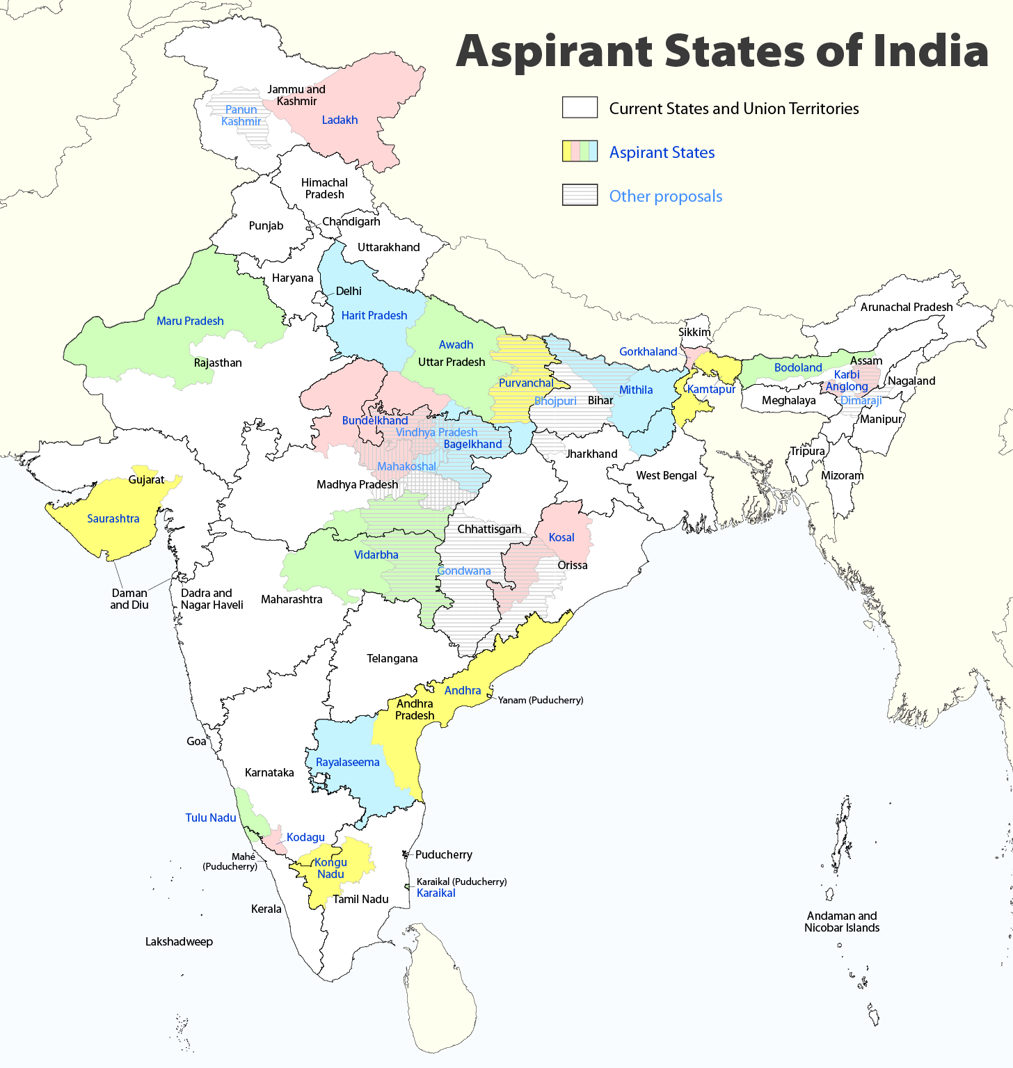
English: Aspirant States of India |
| Ημερομηνία | |
| Πηγή | Έργο αυτού που το ανεβάζει |
| Δημιουργός | Maximilian Dörrbecker (Chumwa) |
| Άδεια (Επαναχρησιμοποίηση αυτού του αρχείου) |
Εγώ, ο κάτοχος των πνευματικών δικαιωμάτων αυτού του έργου, το δημοσιεύω δια του παρόντος υπό την εξής άδεια χρήσης: Το αρχείο διανέμεται υπό την άδεια Creative Commons Αναφορά προέλευσης-Παρόμοια διανομή 2.5 Γενική
Sie dürfen das Bild zu den folgenden Bedingungen nutzen:
|
| άλλες εκδόσεις |
|

Ιστορικό αρχείου
Κλικάρετε σε μια ημερομηνία/ώρα για να δείτε το αρχείο όπως εμφανιζόταν εκείνη τη στιγμή.
| Ώρα/Ημερομ. | Μικρογραφία | Διαστάσεις | Χρήστης | Σχόλια | |
|---|---|---|---|---|---|
| τελευταία | 09:06, 2 Αυγούστου 2020 | | 1.456 × 1.535 (332 KB) | Chumwa | Reverted to version as of 21:03, 29 August 2018 (UTC) |
| 20:03, 30 Ιουλίου 2020 |  | 1.456 × 1.535 (316 KB) | UT'sIndia | Reverted to version as of 15:15, 17 May 2013 (UTC) | |
| 21:03, 29 Αυγούστου 2018 |  | 1.456 × 1.535 (332 KB) | Chumwa | extended Tulu Nadu into Kerala | |
| 21:52, 5 Ιουνίου 2014 |  | 1.456 × 1.535 (332 KB) | Chumwa | borders of Rayalseema corrected | |
| 18:23, 3 Ιουνίου 2014 |  | 1.456 × 1.535 (332 KB) | Chumwa | borders of Mithila corrected | |
| 17:53, 3 Ιουνίου 2014 |  | 1.456 × 1.535 (331 KB) | Chumwa | Telangana now is an official state | |
| 15:16, 17 Μαΐου 2013 |  | 1.456 × 1.535 (316 KB) | Cromium | Removed large title; enlarged map key with slightly different wording | |
| 15:15, 17 Μαΐου 2013 |  | 1.456 × 1.535 (316 KB) | Cromium | Removed large title; enlarged map key with slightly different wording | |
| 22:32, 2 Ιανουαρίου 2012 |  | 1.456 × 1.535 (312 KB) | Chumwa | added some other aspirant states | |
| 21:16, 2 Ιανουαρίου 2012 |  | 1.456 × 1.535 (292 KB) | Chumwa | added a map key |
Συνδέσεις αρχείου
Δεν υπάρχουν σελίδες που συνδέουν σε αυτό το αρχείο.
Καθολική χρήση αρχείου
Τα ακόλουθα άλλα wiki χρησιμοποιούν αυτό το αρχείο:
- Χρήση σε bn.wikipedia.org
- Χρήση σε de.wikipedia.org
- Χρήση σε en.wikipedia.org
- Delhi
- Gondwana (India)
- Kodagu district
- Mithila (proposed Indian state)
- Awadh
- Vidarbha
- Bundelkhand
- Bagelkhand
- Tulu Nadu
- Rayalaseema
- Purvanchal
- Bodoland Territorial Region
- Karbi Anglong district
- Mahakoshal
- Kongu Nadu
- Cooch Behar district
- Gird, India
- Mara Autonomous District Council
- Tripura Tribal Areas Autonomous District Council
- Malabar District
- Gorkhaland movement
- Kamtapur
- Proposed states and union territories of India
- Autonomous administrative divisions of India
- Karaikal district
- Panun Kashmir
- Chakma Autonomous District Council
- Lai Autonomous District Council
- Khasi Hills Autonomous District Council
- Jaintia Hills Autonomous District Council
- Garo Hills Autonomous District Council
- Template:Proposed states and union territories of India
- Tulu Nadu state movement
- Kosal state movement
- User:AbhisheksinghWIKI/Law and Order(India)
- Gorkhaland Territorial Administration
- Tipraland
- Kalyana-Karnataka
- Sadar Hills
- West Karbi Anglong district
Δείτε περισσότερη καθολική χρήση αυτού του αρχείου.