
Αρχείο:Map Crusader states ca. 1100.jpg
Εικόνα σε υψηλότερη ανάλυση (454 × 1.114 εικονοστοιχεία, μέγεθος αρχείου: 157 KB, τύπος MIME: image/jpeg)
|
|
Αυτό το αρχείο και η περιγραφή του προέρχονται από το Wikimedia Commons. Οι πληροφορίες από την σελίδα περιγραφής του εκεί εμφανίζονται παρακάτω. |
Σύνοψη
| Περιγραφή |
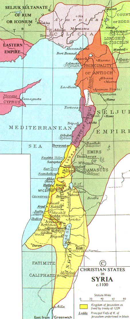
Čeština: Křižácké státy na Blízkém východě
Deutsch: Karte der Kreuzfahrerstaaten, ca. 1100.
English: Crusader states
Français : Etats latins d'Orient
Slovenčina: Križiacke štáty v Levante |
| Ημερομηνία | |
| Πηγή | Muir's Historical Atlas (1911), at http://www.fordham.edu/halsall/sbookmap.html |
| Δημιουργός |

|
This historical map image could be re-created using vector graphics as an SVG file. This has several advantages; see Commons:Media for cleanup for more information. If an SVG form of this image is available, please upload it and afterwards replace this template with
{{vector version available|new image name}}.
It is recommended to name the SVG file “Map Crusader states ca. 1100.svg”—then the template Vector version available (or Vva) does not need the new image name parameter. |


Αδειοδότηση
|
Αυτό το έργο είναι κοινό κτήμα στη χώρα προέλευσής του και άλλες χώρες και περιοχές όπου η διάρκεια πνευματικών δικαιωμάτων είναι όσο η ζωή του δημιουργού και μέχρι 70 χρόνια μετά ή λιγότερο.
| |
| Αυτό το αρχείο έχει χαρακτηριστεί ως απαλλαγμένο από γνωστούς περιορισμούς βάσει της νομοθεσίας περί πνευματικής ιδιοκτησίας, περιλαμβανομένων όλων των συναφών και συγγενικών δικαιωμάτων. | |
Ιστορικό αρχείου
Κλικάρετε σε μια ημερομηνία/ώρα για να δείτε το αρχείο όπως εμφανιζόταν εκείνη τη στιγμή.
| Ώρα/Ημερομ. | Μικρογραφία | Διαστάσεις | Χρήστης | Σχόλια | |
|---|---|---|---|---|---|
| τελευταία | 22:18, 1 Ιουνίου 2005 | 454 × 1.114 (157 KB) | Helix84 | {{English}} Crusader states {{Slovak}} Križiacke štáty v Levante ==Source== Muir's Historical Atlas (1911), at http://www.fordham.edu/halsall/sbookmap.html (from en:image:Crusaderstates.jpg) |
Συνδέσεις αρχείου
Τα παρακάτω λήμματα συνδέουν σε αυτό το αρχείο:
Καθολική χρήση αρχείου
Τα ακόλουθα άλλα wiki χρησιμοποιούν αυτό το αρχείο:
- Χρήση σε af.wikipedia.org
- Χρήση σε als.wikipedia.org
- Χρήση σε ar.wikipedia.org
- Χρήση σε arz.wikipedia.org
- Χρήση σε ast.wikipedia.org
- Χρήση σε azb.wikipedia.org
- Χρήση σε az.wikipedia.org
- Χρήση σε br.wikipedia.org
- Χρήση σε bxr.wikipedia.org
- Χρήση σε ca.wikipedia.org
- Χρήση σε cs.wikipedia.org
- Χρήση σε de.wikipedia.org
- Χρήση σε en.wikipedia.org
- Χρήση σε eo.wikipedia.org
- Χρήση σε et.wikipedia.org
- Χρήση σε fa.wikipedia.org
- Χρήση σε fi.wikipedia.org
- Χρήση σε fr.wikipedia.org
- Χρήση σε gl.wikipedia.org
- Χρήση σε he.wikipedia.org
- Χρήση σε hr.wikipedia.org
- Χρήση σε hu.wikipedia.org
- Χρήση σε id.wikipedia.org
- Χρήση σε it.wikipedia.org
- Χρήση σε ja.wikipedia.org
- Χρήση σε ka.wikipedia.org
Δείτε περισσότερη καθολική χρήση αυτού του αρχείου.