Αρχείο:National Map of Switzerland.jpg

Τα περιεχόμενα της σελίδας δεν υποστηρίζονται σε άλλες γλώσσες.
Αυτό το αρχείο προέρχεται από το Wikimedia Commons
Από τη Βικιπαίδεια, την ελεύθερη εγκυκλοπαίδεια

Εικόνα σε υψηλότερη ανάλυση(15.400 × 9.600 εικονοστοιχεία, μέγεθος αρχείου: 47,49 MB, τύπος MIME: image/jpeg)

Σύνοψη

Προσοχή Μερικοί φυλλομετρητές ίσως αντιμετωπίσουν πρόβλημα με την απεικόνιση αυτής της εικόνας σε πλήρη ανάλυση: Αυτή η εικόνα έχει πολύ μεγάλο αριθμό πίξελς και μπορεί είτε να μη φορτωθεί κανονικά είτε ο φυλλομετρητής να κολλήσει.
Τίτλος
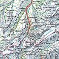
English: National Map of Switzerland
Περιγραφή
English: Electronic version of the National Map of Switzerland (1:500'000) published by the Federal Office of Topography (swisstopo). Made from a compressed TIFF file. Scale is 25 metres per pixel. Nota bene: The map can be consulted more conveniently on the geographical portal.
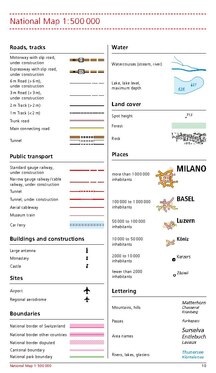
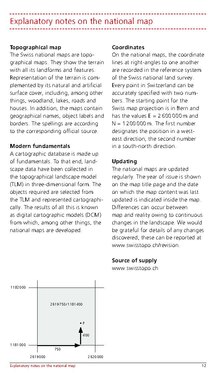
Map legend

Conventional signs for Swiss National Maps (pp. 10, 12)

Ημερομηνία
Πηγή
Δημιουργός
institution QS:P195,Q685592
 Geotemporal data
Map location Switzerland
Spatial reference system Swiss coordinate system (CH1903+/MN95)
Scale 1:500.000
Heading
Georeferencing Georeference the map in Wikimaps Warper If inappropriate please set warp_status = skip to hide.
άλλες εκδόσεις
Object location46° 48′ 00″ N, 8° 13′ 48″ E Kartographer map based on OpenStreetMap.View this and other nearby images on: OpenStreetMapinfo

Αδειοδότηση

The data made publicly available by swisstopo may be used, distributed and made accessible. Furthermore, they may be enriched and processed and also used commercially.

A reference to the source is mandatory. In the case of digital or analogue representations and publications, as well as in the case of dissemination, one of the following source references must be attached in any case:

  • Federal Office of Topography swisstopo
  • Bundesamt für Landestopografie swisstopo
  • Office fédéral de topographie swisstopo
  • Ufficio federale di topografia swisstopo
  • Uffizi federal da topografia swisstopo
  • ©swisstopo

Terms of use for free geodata and geoservices (OGD) from swisstopo
Frequently asked questions about free basic geodata


Deutsch | français | italiano | English | +/−

Λεζάντες

Δεν ορίστηκε λεζάντα

Items portrayed in this file

απεικονίζει

checksum Αγγλικά

4d6b57a3bfb9531b3f16cfc58452a8ade912c661

data size Αγγλικά

49.795.663 Byte

9.600 εικονοστοιχείο

15.400 εικονοστοιχείο

46°48'0.000"N, 8°13'48.000"E

Ιστορικό αρχείου

Κλικάρετε σε μια ημερομηνία/ώρα για να δείτε το αρχείο όπως εμφανιζόταν εκείνη τη στιγμή.

Ώρα/Ημερομ.ΜικρογραφίαΔιαστάσειςΧρήστηςΣχόλια
τελευταία13:29, 3 Δεκεμβρίου 2021Μικρογραφία για την έκδοση της 13:29, 3 Δεκεμβρίου 202115.400 × 9.600 (47,49 MB)Zacharie GrossenUploaded a work by Bundesamt für Landestopografie swisstopo from *Original TIFF file: [https://www.swisstopo.admin.ch/en/geodata/maps/smr/smr500.html Swiss Map Raster 500] *Geographical portal: [https://map.geo.admin.ch map.geo.admin.ch] with UploadWizard

Δεν υπάρχουν σελίδες που συνδέουν σε αυτό το αρχείο.