
Αρχείο:Ireland.svg

Το μέγεθος αυτής της PNG προεπισκόπησης αυτού του SVG το αρχείο: 471 × 599 εικονοστοιχεία. Άλλες αναλύσεις: 188 × 240 εικονοστοιχεία | 377 × 480 εικονοστοιχεία | 603 × 768 εικονοστοιχεία | 804 × 1.024 εικονοστοιχεία | 1.609 × 2.048 εικονοστοιχεία | 2.200 × 2.800 εικονοστοιχεία.
Εικόνα σε υψηλότερη ανάλυση (Αρχείο SVG, ονομαστικό μέγεθος 2.200 × 2.800 εικονοστοιχεία, μέγεθος αρχείου: 204 KB)
|
|
Αυτό το αρχείο και η περιγραφή του προέρχονται από το Wikimedia Commons. Οι πληροφορίες από την σελίδα περιγραφής του εκεί εμφανίζονται παρακάτω. |
Σύνοψη
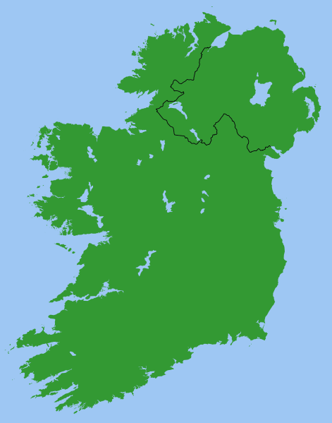
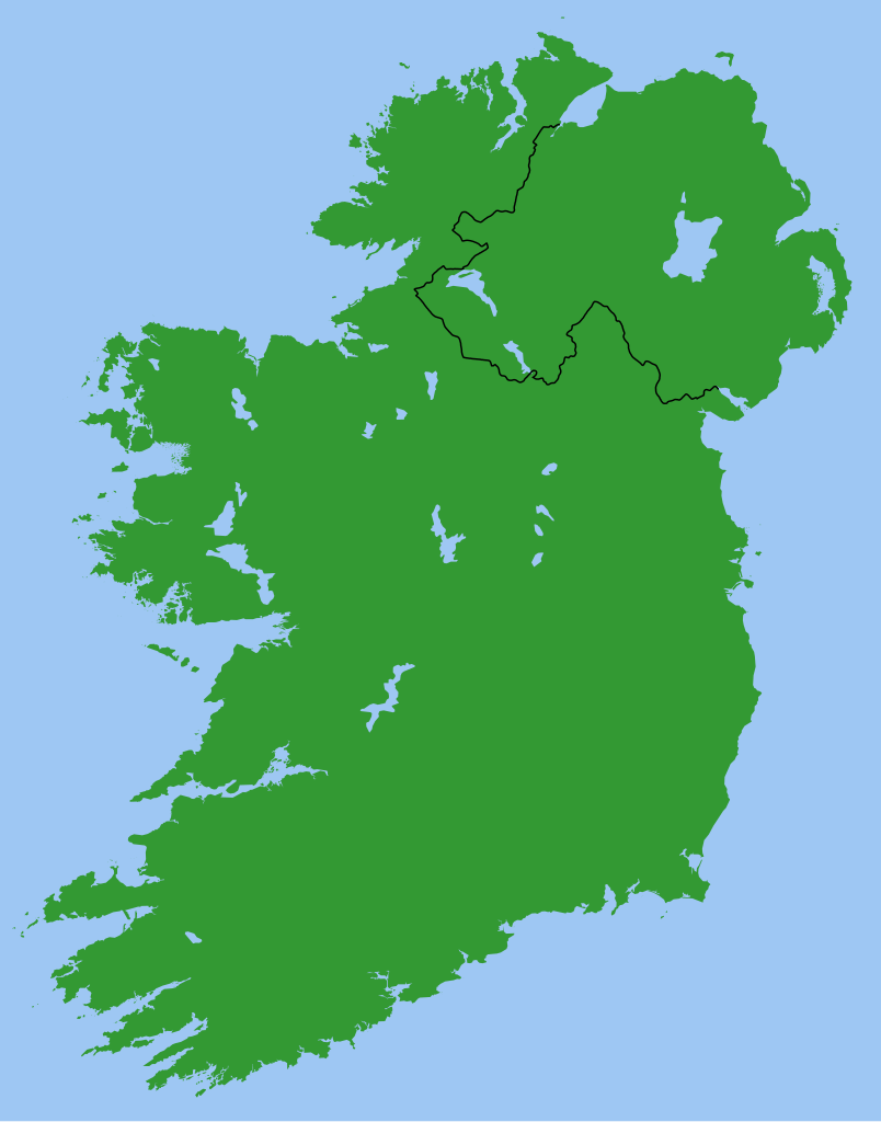
Map of Ireland, with North-South boundary delimited.
SVG should be fairly easy to alter or expand. For example the following can all be achieved with one-line CSS changes:
- You can toggle the Northern Ireland border on/off or change its thickness
- You can change any of the colours
- You can draw a border around all the land to make it more distinct from the sea
- You can hide Northern Ireland or the Republic of Ireland.
You can also do any of the following just by changing or adding/removing a few lines of SVG code:
- Zoom in on Northern Ireland, the Munster shoreline, or any other area
- Remove all the small islands (e.g. for faster rendering)
- Add drop shadows (feGaussianBlur), textured ground (feTurbulance) or topography (feDisplacementMap + feSpecularLighting)
- Add cities and towns.
- Add rivers. Anyone care to do this?
Originally derived from Image:Lough-Neagh.svg.
Αδειοδότηση
| Εγώ, ο κάτοχος των πνευματικών δικαιωμάτων αυτού του έργου, δημοσιεύω αυτό το έργο ως κοινό κτήμα. Αυτό ισχύει σε παγκόσμια κλίμακα. Σε ορισμένες χώρες αυτό μπορεί να μην είναι νομικά εφικτό. Αν ναι: Παραχωρώ σε οποιονδήποτε το δικαίωμα να χρησιμοποιήσει αυτό το έργο "για οποιονδήποτε σκοπό", χωρίς κανέναν όρο, εκτός και αν τέτοιοι όροι τίθενται από την νομοθεσία |
s]]
Ιστορικό αρχείου
Κλικάρετε σε μια ημερομηνία/ώρα για να δείτε το αρχείο όπως εμφανιζόταν εκείνη τη στιγμή.
| Ώρα/Ημερομ. | Μικρογραφία | Διαστάσεις | Χρήστης | Σχόλια | |
|---|---|---|---|---|---|
| τελευταία | 21:49, 13 Μαρτίου 2007 | | 2.200 × 2.800 (204 KB) | Nickshanks | increased default size, modified lough Erne |
| 21:19, 13 Μαρτίου 2007 |  | 550 × 700 (204 KB) | Nickshanks | Map of Ireland, with North-South boundary delimited.<br/> SVG should be fairly easy to alter or expand. Northern Ireland is a separate group element<br/> Needs rivers adding. Anyone care to do this? Originally derived from Image:Lough-Neagh.svg. |
Συνδέσεις αρχείου
Δεν υπάρχουν σελίδες που συνδέουν σε αυτό το αρχείο.
Καθολική χρήση αρχείου
Τα ακόλουθα άλλα wiki χρησιμοποιούν αυτό το αρχείο:
- Χρήση σε ca.wikipedia.org
- Χρήση σε en.wikipedia.org
- Michael Collins (Irish leader)
- Irish Boundary Commission
- Talk:Ireland (disambiguation)
- Repartition of Ireland
- User talk:BrownHairedGirl/Archive/Archive 012
- User:Roadnote/Ireland
- Wikipedia talk:WikiProject Eurovision/Archive 3
- List of Irish Presbyteries
- National symbols of Ireland, the Republic of Ireland and Northern Ireland
- Χρήση σε es.wikipedia.org
- Χρήση σε fa.wikipedia.org
- Χρήση σε fr.wikipedia.org
- Χρήση σε ga.wikipedia.org
- Χρήση σε it.wikipedia.org
- Χρήση σε no.wikipedia.org
- Χρήση σε pl.wikipedia.org
- Χρήση σε pt.wikipedia.org
- Χρήση σε ru.wikipedia.org
- Χρήση σε simple.wikipedia.org
- Χρήση σε sl.wikipedia.org
- Χρήση σε sv.wikipedia.org