
Αρχείο:Gulf of Taranto, Italy ESA19459765.jpeg

Εικόνα σε υψηλότερη ανάλυση (7.172 × 4.198 εικονοστοιχεία, μέγεθος αρχείου: 5,84 MB, τύπος MIME: image/jpeg)
|
|
Αυτό το αρχείο και η περιγραφή του προέρχονται από το Wikimedia Commons. Οι πληροφορίες από την σελίδα περιγραφής του εκεί εμφανίζονται παρακάτω. |
Σύνοψη
| Περιγραφή |
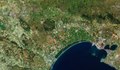
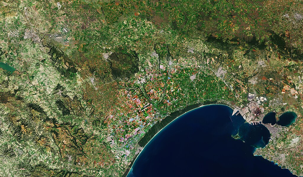
English: The Copernicus Sentinel-2 mission takes us over the Gulf of Taranto, located on the inner heel of southern Italy. Taranto, an important coastal city, is visible on the bottom right of the image. Founded by a Greek colony in the 8th century BC, the city is now an important commercial port. The islets of San Pietro and San Paolo, known as the Cheradi Islands, protect the Mar Grande, the main commercial port of the city. It is separated from the Mar Piccolo, an inland lagoon, by a cape which closes the gulf. The industrial district, which is visible northwest of the city, has a high number of factories, oil refineries, steelworks and iron foundries. Along the coast, the Aleppo pine forest of the Stornara Nature Reserve is clearly visible in dark green. It takes its name from the many starlings that migrate there during winter. The reserve was founded in 1977 and covers an area of approximately 1500 hectares. Directly above the forest, many various patches of agricultural fields can be seen. Favoured by the Mediterranean climate, the food sector has been one of the strongest areas of the Apulian economy. Fruit, vegetables and cereals are grown in a range of crop types throughout the region, depending on the time of year. The blue patches visible are greenhouses. Considered as the 2019 European Capital of Culture along with Plovdiv, in Bulgaria, Matera can be seen in the top left of the image, in the Basilicata region. Matera hosts an important space hub. The Giuseppe Colombo Centre for Space Geodesy, founded by the Italian Space Agency, is located here. It sends regular laser beams to the moon, where they reach reflectors that were placed there during the original Apollo missions and the Lunokhod Soviet robotic missions. These lasers measure the distance from the Earth to the moon, expanding our knowledge of the moon’s internal structure. Located next door, the Matera Space Centre is one of the ground stations for the reception and processing of data acquired by the Copernicus Sentinel satellites for ESA. Copernicus Sentinel-2 is a two-satellite mission. Each satellite carries a high-resolution camera that images Earth’s surface in 13 spectral bands. Data from Copernicus Sentinel-2 can help monitor changes in land cover. This image, captured on 6 March 2019, is also featured on the Earth from Space video programme. |
| Ημερομηνία | 28 Ιουνίου 2019 (upload date) |
| Πηγή | Gulf of Taranto, Italy |
| Δημιουργός | European Space Agency |
| άλλες εκδόσεις |
|
| Activity | Observing the Earth |
| Mission | Sentinel-2 |
| Set | Earth observation image of the week |
| System | Copernicus |
.jpeg)
.jpeg)
Αδειοδότηση

|
This image contains data from a satellite in the Copernicus Programme, such as Sentinel-1, Sentinel-2 or Sentinel-3. Attribution is required when using this image.
Απόδοση: Contains modified Copernicus Sentinel data 2019
The use of Copernicus Sentinel Data is regulated under EU law (Commission Delegated Regulation (EU) No 1159/2013 and Regulation (EU) No 377/2014). Relevant excerpts:
Free access shall be given to GMES dedicated data [...] made available through GMES dissemination platforms [...].
Access to GMES dedicated data [...] shall be given for the purpose of the following use in so far as it is lawful:
GMES dedicated data [...] may be used worldwide without limitations in time.
GMES dedicated data and GMES service information are provided to users without any express or implied warranty, including as regards quality and suitability for any purpose. |
This media was created by the European Space Agency (ESA).
Where expressly so stated, images or videos are covered by the Creative Commons Attribution-ShareAlike 3.0 IGO (CC BY-SA 3.0 IGO) licence, ESA being an Intergovernmental Organisation (IGO), as defined by the CC BY-SA 3.0 IGO licence. The user is allowed under the terms and conditions of the CC BY-SA 3.0 IGO license to Reproduce, Distribute and Publicly Perform the ESA images and videos released under CC BY-SA 3.0 IGO licence and the Adaptations thereof, without further explicit permission being necessary, for as long as the user complies with the conditions and restrictions set forth in the CC BY-SA 3.0 IGO licence, these including that:
See the ESA Creative Commons copyright notice for complete information, and this article for additional details.
|
 | |
Αυτό το αρχείο διανέμεται υπό την άδεια Creative Commons Αναφορά προέλευσης -Παρόμοια διανομή 3.0 IGO Απόδοση: ESA, CC BY-SA IGO 3.0
| ||
Ιστορικό αρχείου
Κλικάρετε σε μια ημερομηνία/ώρα για να δείτε το αρχείο όπως εμφανιζόταν εκείνη τη στιγμή.
| Ώρα/Ημερομ. | Μικρογραφία | Διαστάσεις | Χρήστης | Σχόλια | |
|---|---|---|---|---|---|
| τελευταία | 13:25, 7 Ιουνίου 2020 | | 7.172 × 4.198 (5,84 MB) | OptimusPrimeBot | #Spacemedia - Upload of https://www.esa.int/var/esa/storage/images/esa_multimedia/images/2019/06/gulf_of_taranto_italy/19459754-2-eng-GB/Gulf_of_Taranto_Italy.jpg via Commons:Spacemedia |
Συνδέσεις αρχείου
Δεν υπάρχουν σελίδες που συνδέουν σε αυτό το αρχείο.