
Αρχείο:Bessarabia.png

Εικόνα σε υψηλότερη ανάλυση (544 × 607 εικονοστοιχεία, μέγεθος αρχείου: 49 KB, τύπος MIME: image/png)
|
|
Αυτό το αρχείο και η περιγραφή του προέρχονται από το Wikimedia Commons. Οι πληροφορίες από την σελίδα περιγραφής του εκεί εμφανίζονται παρακάτω. |
Σύνοψη
| Περιγραφή |
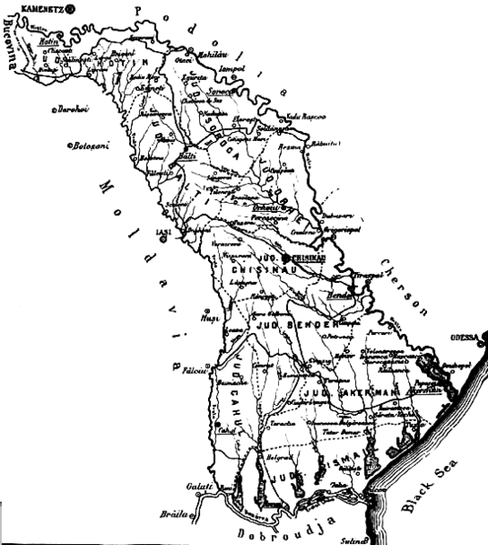
English: The map of the region of Bessarabia (1812-1917) Română: Harta Basarabiei Русский: Карта Бессарабии |
| Ημερομηνία | |
| Πηγή | http://depts.washington.edu/cartah/text_archive/clark/b_22.jpg |
| Δημιουργός | Celeron |
Αδειοδότηση
|
Αυτό το έργο είναι κοινό κτήμα στη χώρα προέλευσής του και άλλες χώρες και περιοχές όπου η διάρκεια πνευματικών δικαιωμάτων είναι όσο η ζωή του δημιουργού και μέχρι 70 χρόνια μετά ή λιγότερο.
| |
| Αυτό το αρχείο έχει χαρακτηριστεί ως απαλλαγμένο από γνωστούς περιορισμούς βάσει της νομοθεσίας περί πνευματικής ιδιοκτησίας, περιλαμβανομένων όλων των συναφών και συγγενικών δικαιωμάτων. | |
Comment 1
better version of map at 
Comment 2
This map is from the book "Bessarabia, Russia, and Roumania on the Black Sea" by Charles Upson Clark.
An electronic version of the book is available online: http://depts.washington.edu/cartah/text_archive/clark/meta_pag.shtml
Ιστορικό αρχείου
Κλικάρετε σε μια ημερομηνία/ώρα για να δείτε το αρχείο όπως εμφανιζόταν εκείνη τη στιγμή.
| Ώρα/Ημερομ. | Μικρογραφία | Διαστάσεις | Χρήστης | Σχόλια | |
|---|---|---|---|---|---|
| τελευταία | 20:52, 19 Μαΐου 2006 | | 544 × 607 (49 KB) | Zserghei | This image was copied from wikipedia:en. The original description was: {{PD}} ==Comment 1== better version of map at Image:Bessarabia.jpg ==Comment 2== This map is from the book "Bessarabia, Russia, and Roumania on the Black Sea" by Charles Upson C |
| 00:47, 3 Οκτωβρίου 2005 |  | 544 × 607 (49 KB) | Celeron | {{pd}} bessarabia's map |
Συνδέσεις αρχείου
Δεν υπάρχουν σελίδες που συνδέουν σε αυτό το αρχείο.
Καθολική χρήση αρχείου
Τα ακόλουθα άλλα wiki χρησιμοποιούν αυτό το αρχείο:
- Χρήση σε ar.wikipedia.org
- Χρήση σε ast.wikipedia.org
- Χρήση σε beta.wikiversity.org
- Χρήση σε ca.wikipedia.org
- Χρήση σε cs.wikipedia.org
- Χρήση σε dsb.wikipedia.org
- Χρήση σε en.wikipedia.org
- Χρήση σε es.wikipedia.org
- Χρήση σε eu.wikipedia.org
- Χρήση σε id.wikipedia.org
- Χρήση σε is.wikipedia.org
- Χρήση σε it.wikipedia.org
- Χρήση σε ko.wikipedia.org
- Χρήση σε mk.wikipedia.org
- Χρήση σε ms.wikipedia.org
- Χρήση σε nl.wikipedia.org
- Χρήση σε no.wikipedia.org
- Χρήση σε pl.wikipedia.org
- Χρήση σε pnb.wikipedia.org
- Χρήση σε ro.wikipedia.org
- Χρήση σε sl.wikipedia.org
- Χρήση σε sq.wikipedia.org
- Χρήση σε sv.wikipedia.org
- Χρήση σε tr.wikipedia.org
- Χρήση σε uk.wikipedia.org
- Χρήση σε ur.wikipedia.org
- Χρήση σε vi.wikipedia.org
- Χρήση σε zh.wikipedia.org