
Αρχείο:Antarctic Region.png
Μέγεθος αυτής της προεπισκόπησης: 486 × 599 εικονοστοιχεία . Άλλες αναλύσεις: 195 × 240 εικονοστοιχεία | 389 × 480 εικονοστοιχεία | 623 × 768 εικονοστοιχεία | 830 × 1.024 εικονοστοιχεία | 1.661 × 2.048 εικονοστοιχεία | 2.787 × 3.437 εικονοστοιχεία.
Εικόνα σε υψηλότερη ανάλυση (2.787 × 3.437 εικονοστοιχεία, μέγεθος αρχείου: 1,4 MB, τύπος MIME: image/png)
|
|
Αυτό το αρχείο και η περιγραφή του προέρχονται από το Wikimedia Commons. Οι πληροφορίες από την σελίδα περιγραφής του εκεί εμφανίζονται παρακάτω. |
| Περιγραφή |
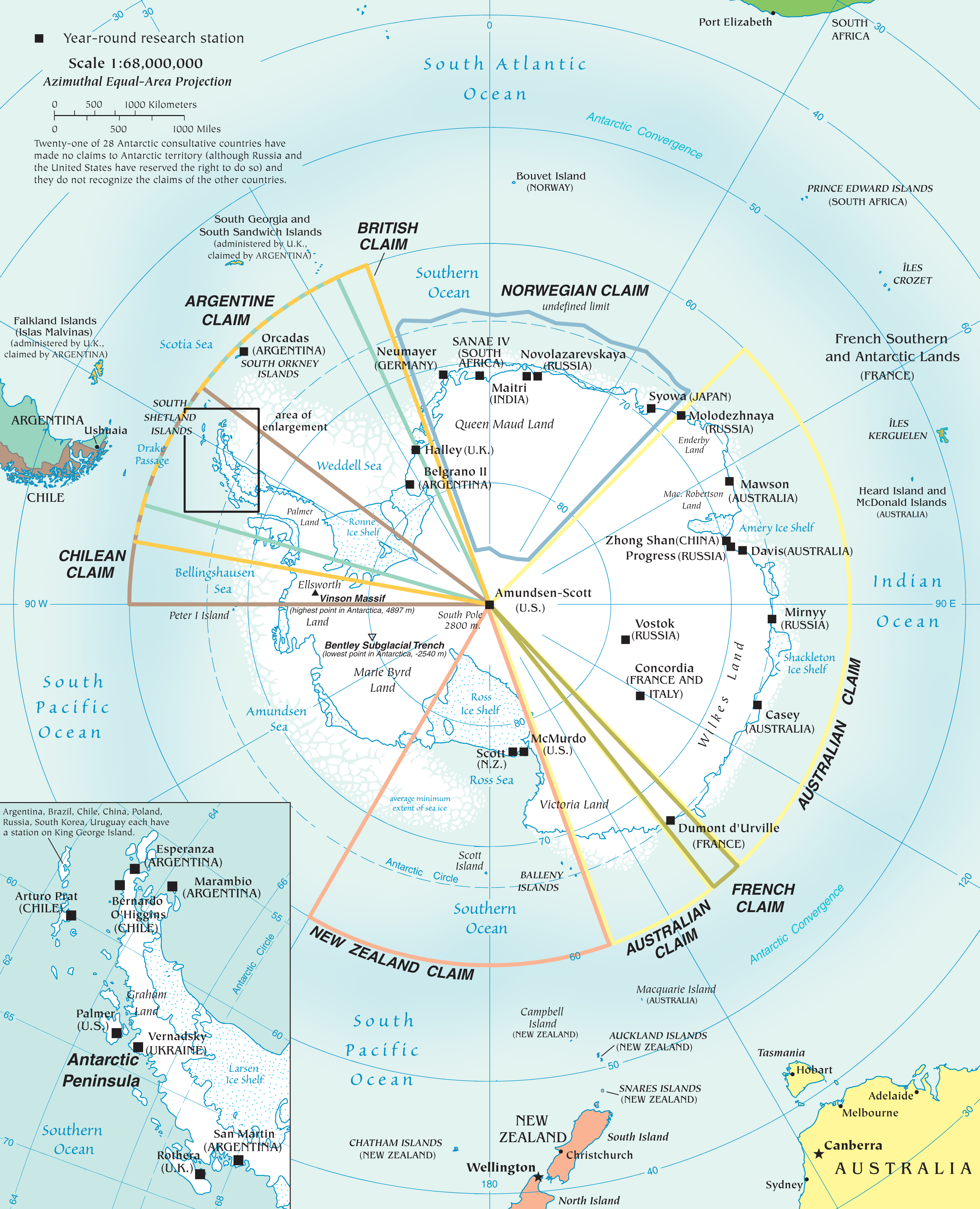
English: Map of the antarctic region
Twenty-one of 28 Antarctic consultative countries have made no claims to Antarctic territory (although Russia and the United States have reserved the right to do so) and they do not recognize the claims of the other countries. Español: Mapa de la Antártida |
| Ημερομηνία | |
| Πηγή | PDF at CIA Factbook |
| Δημιουργός | The World Factbook |
This image is in the public domain because it contains materials that originally came from the United States Central Intelligence Agency's World Factbook.
|
 |
Ιστορικό αρχείου
Κλικάρετε σε μια ημερομηνία/ώρα για να δείτε το αρχείο όπως εμφανιζόταν εκείνη τη στιγμή.
| Ώρα/Ημερομ. | Μικρογραφία | Διαστάσεις | Χρήστης | Σχόλια | |
|---|---|---|---|---|---|
| τελευταία | 18:10, 3 Δεκεμβρίου 2010 | | 2.787 × 3.437 (1,4 MB) | Ras67 | better arrangement of Antarctic Peninsula enlargement |
| 20:01, 2 Δεκεμβρίου 2010 |  | 2.787 × 3.437 (1,4 MB) | Ras67 | {{Information |Description={{en|1=Map of the antarctic region<br /> Twenty-one of 28 Antarctic consultative countries have made no claims to Antarctic territory (although Russia and the United States have reserved the right to do so) and they do not recog |
Συνδέσεις αρχείου
Δεν υπάρχουν σελίδες που συνδέουν σε αυτό το αρχείο.
Καθολική χρήση αρχείου
Τα ακόλουθα άλλα wiki χρησιμοποιούν αυτό το αρχείο:
- Χρήση σε af.wikipedia.org
- Χρήση σε an.wikipedia.org
- Χρήση σε ar.wikipedia.org
- Χρήση σε ast.wikipedia.org
- Χρήση σε az.wikipedia.org
- Χρήση σε be-tarask.wikipedia.org
- Χρήση σε be.wikipedia.org
- Χρήση σε ca.wikipedia.org
- Χρήση σε cs.wikipedia.org
- Χρήση σε de.wikipedia.org
- Χρήση σε de.wikivoyage.org
- Χρήση σε en.wikipedia.org
- Χρήση σε eo.wikipedia.org
- Χρήση σε eu.wikipedia.org
- Χρήση σε fr.wikipedia.org
- Χρήση σε hi.wikipedia.org
- Χρήση σε hu.wikipedia.org
- Χρήση σε hy.wikipedia.org
- Χρήση σε id.wikipedia.org
- Χρήση σε ilo.wikipedia.org
- Χρήση σε ja.wikipedia.org
- Χρήση σε min.wikipedia.org
- Χρήση σε ms.wikipedia.org
- Χρήση σε nl.wikipedia.org
- Χρήση σε nn.wikipedia.org
- Χρήση σε ro.wikipedia.org
- Χρήση σε su.wikipedia.org
- Χρήση σε sv.wikipedia.org
- Χρήση σε uk.wikipedia.org
Δείτε περισσότερη καθολική χρήση αυτού του αρχείου.