
Αρχείο:Prince Edward Island-map.png
Δεν διατίθεται υψηλότερη ανάλυση.
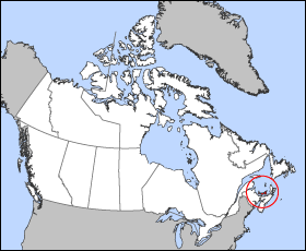
Prince_Edward_Island-map.png (280 × 230 εικονοστοιχεία, μέγεθος αρχείου: 15 KB, τύπος MIME: image/png)
|
|
Αυτό το αρχείο και η περιγραφή του προέρχονται από το Wikimedia Commons. Οι πληροφορίες από την σελίδα περιγραφής του εκεί εμφανίζονται παρακάτω. |
Map of Prince Edward Island
Projection: Lambert azimuthal equal-area
Geospatial data from: The Atlas of Canada, The National Atlas of the United States and U.S. Geological Survey
Cartographer: John Fowler
| Εγώ, ο κάτοχος των πνευματικών δικαιωμάτων αυτού του έργου, δημοσιεύω αυτό το έργο ως κοινό κτήμα. Αυτό ισχύει σε παγκόσμια κλίμακα. Σε ορισμένες χώρες αυτό μπορεί να μην είναι νομικά εφικτό. Αν ναι: Παραχωρώ σε οποιονδήποτε το δικαίωμα να χρησιμοποιήσει αυτό το έργο "για οποιονδήποτε σκοπό", χωρίς κανέναν όρο, εκτός και αν τέτοιοι όροι τίθενται από την νομοθεσία |
Ιστορικό αρχείου
Κλικάρετε σε μια ημερομηνία/ώρα για να δείτε το αρχείο όπως εμφανιζόταν εκείνη τη στιγμή.
| Ώρα/Ημερομ. | Μικρογραφία | Διαστάσεις | Χρήστης | Σχόλια | |
|---|---|---|---|---|---|
| τελευταία | 12:17, 24 Μαρτίου 2005 | | 280 × 230 (15 KB) | Voyager | Map of Prince Edward Island Projection: Lambert azimuthal equal-area Geospatial data from: [http://atlas.gc.ca/ The Atlas of Canada], [http://www.nationalatlas.gov/ The National Atlas of the United States] and [http://www.usgs.gov U.S. Geological Survey |
Συνδέσεις αρχείου
Δεν υπάρχουν σελίδες που συνδέουν σε αυτό το αρχείο.
Καθολική χρήση αρχείου
Τα ακόλουθα άλλα wiki χρησιμοποιούν αυτό το αρχείο:
- Χρήση σε bat-smg.wikipedia.org
- Χρήση σε be.wikipedia.org
- Χρήση σε br.wikipedia.org
- Χρήση σε en.wikipedia.org
- Χρήση σε en.wiktionary.org
- Χρήση σε eo.wikipedia.org
- Χρήση σε fi.wikivoyage.org
- Χρήση σε frr.wikipedia.org
- Χρήση σε hu.wiktionary.org
- Χρήση σε hy.wikipedia.org
- Χρήση σε io.wikipedia.org
- Χρήση σε ja.wikipedia.org
- Χρήση σε ko.wikipedia.org
- Χρήση σε kw.wikipedia.org
- Χρήση σε lij.wikipedia.org
- Χρήση σε mk.wikipedia.org
- Χρήση σε nn.wikipedia.org
- Χρήση σε pam.wikipedia.org
- Χρήση σε pl.wikipedia.org
- Χρήση σε pms.wikipedia.org
- Χρήση σε ru.wikipedia.org
- Χρήση σε sh.wikipedia.org
- Χρήση σε simple.wikipedia.org
- Χρήση σε sl.wikipedia.org
- Χρήση σε uk.wikipedia.org
- Χρήση σε vo.wikipedia.org
- Χρήση σε xmf.wikipedia.org
- Χρήση σε zh-min-nan.wikipedia.org