
Αρχείο:Historical Map of Sikkim in northeastern India.jpg

Εικόνα σε υψηλότερη ανάλυση (4.510 × 3.916 εικονοστοιχεία, μέγεθος αρχείου: 14,76 MB, τύπος MIME: image/jpeg)
|
|
Αυτό το αρχείο και η περιγραφή του προέρχονται από το Wikimedia Commons. Οι πληροφορίες από την σελίδα περιγραφής του εκεί εμφανίζονται παρακάτω. |
Σύνοψη
Αδειοδότηση
This media file is in the public domain in the United States. This applies to U.S. works where the copyright has expired, often because its first publication occurred prior to January 1, 1929, and if not then due to lack of notice or renewal. See this page for further explanation.
|
 | |
 |
This image might not be in the public domain outside of the United States; this especially applies in the countries and areas that do not apply the rule of the shorter term for US works, such as Canada, Mainland China (not Hong Kong or Macao), Germany, Mexico, and Switzerland. The creator and year of publication are essential information and must be provided. See Wikipedia:Public domain and Wikipedia:Copyrights for more details.
|
|
Το δισδιάστατο έργο τέχνης που απεικονίζεται σε αυτή την εικόνα είναι κοινό κτήμα (δηλαδή δεν καλύπτεται από πνευματικά δικαιώματα) παγκόσμια, εξαιτίας της ημερομηνίας θανάτου του δημιουργού του, ή της ημερομηνίας της έκδοσής του.
Συνεπώς και αυτή η αναπαραγωγή του έργου είναι κοινό κτήμα (αυτό ισχύει για αναπαραγωγές που δημιουργήθηκαν στις Ηνωμένες Πολιτείες, την Γερμανία, και πολλές άλλες χώρες).
| ||||
Καταγραφές ανεβασμάτων πρωτότυπου αρχείου
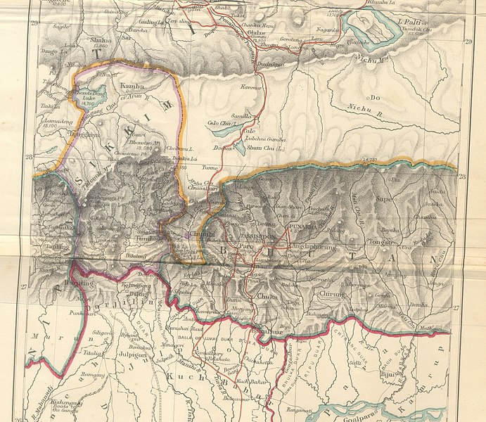
- 2009-10-14 10:25 Hindutashravi 4510×3916× (15480075 bytes) Historical Map of Sikkim in northeastern India extracted from map prepared by Trelawney Saunders, 1876 titled The routes of Bogle, Turner and Manning between Bengal and Tibet, and published in the book Titled, Narratives of the Mission of George Bogle
Ιστορικό αρχείου
Κλικάρετε σε μια ημερομηνία/ώρα για να δείτε το αρχείο όπως εμφανιζόταν εκείνη τη στιγμή.
| Ώρα/Ημερομ. | Μικρογραφία | Διαστάσεις | Χρήστης | Σχόλια | |
|---|---|---|---|---|---|
| τελευταία | 07:38, 25 Ιουνίου 2010 | | 4.510 × 3.916 (14,76 MB) | File Upload Bot (Magnus Manske) | {{BotMoveToCommons|en.wikipedia|year={{subst:CURRENTYEAR}}|month={{subst:CURRENTMONTHNAME}}|day={{subst:CURRENTDAY}}}} {{Information |Description={{en|Historical Map of Sikkim in northeastern India extracted from map prepared by Trelawney Saunders, 1876 |
Συνδέσεις αρχείου
Δεν υπάρχουν σελίδες που συνδέουν σε αυτό το αρχείο.
Καθολική χρήση αρχείου
Τα ακόλουθα άλλα wiki χρησιμοποιούν αυτό το αρχείο:
- Χρήση σε as.wikipedia.org
- Χρήση σε bn.wikipedia.org
- Χρήση σε en.wikipedia.org
- Χρήση σε gu.wikipedia.org
- Χρήση σε he.wikipedia.org
- Χρήση σε hi.wikipedia.org
- Χρήση σε id.wikipedia.org
- Χρήση σε ja.wikipedia.org
- Χρήση σε kn.wikipedia.org
- Χρήση σε my.wikipedia.org
- Χρήση σε nl.wikipedia.org
- Χρήση σε pt.wikipedia.org
- Χρήση σε sa.wikipedia.org
- Χρήση σε si.wikipedia.org
- Χρήση σε ta.wikipedia.org
- Χρήση σε th.wikipedia.org
- Χρήση σε vi.wikipedia.org