
Αρχείο:Greater Croatia 01.png
Μέγεθος αυτής της προεπισκόπησης: 663 × 600 εικονοστοιχεία . Άλλες αναλύσεις: 265 × 240 εικονοστοιχεία | 531 × 480 εικονοστοιχεία | 849 × 768 εικονοστοιχεία | 1.151 × 1.041 εικονοστοιχεία.
Εικόνα σε υψηλότερη ανάλυση (1.151 × 1.041 εικονοστοιχεία, μέγεθος αρχείου: 153 KB, τύπος MIME: image/png)
|
|
Αυτό το αρχείο και η περιγραφή του προέρχονται από το Wikimedia Commons. Οι πληροφορίες από την σελίδα περιγραφής του εκεί εμφανίζονται παρακάτω. |
Σύνοψη
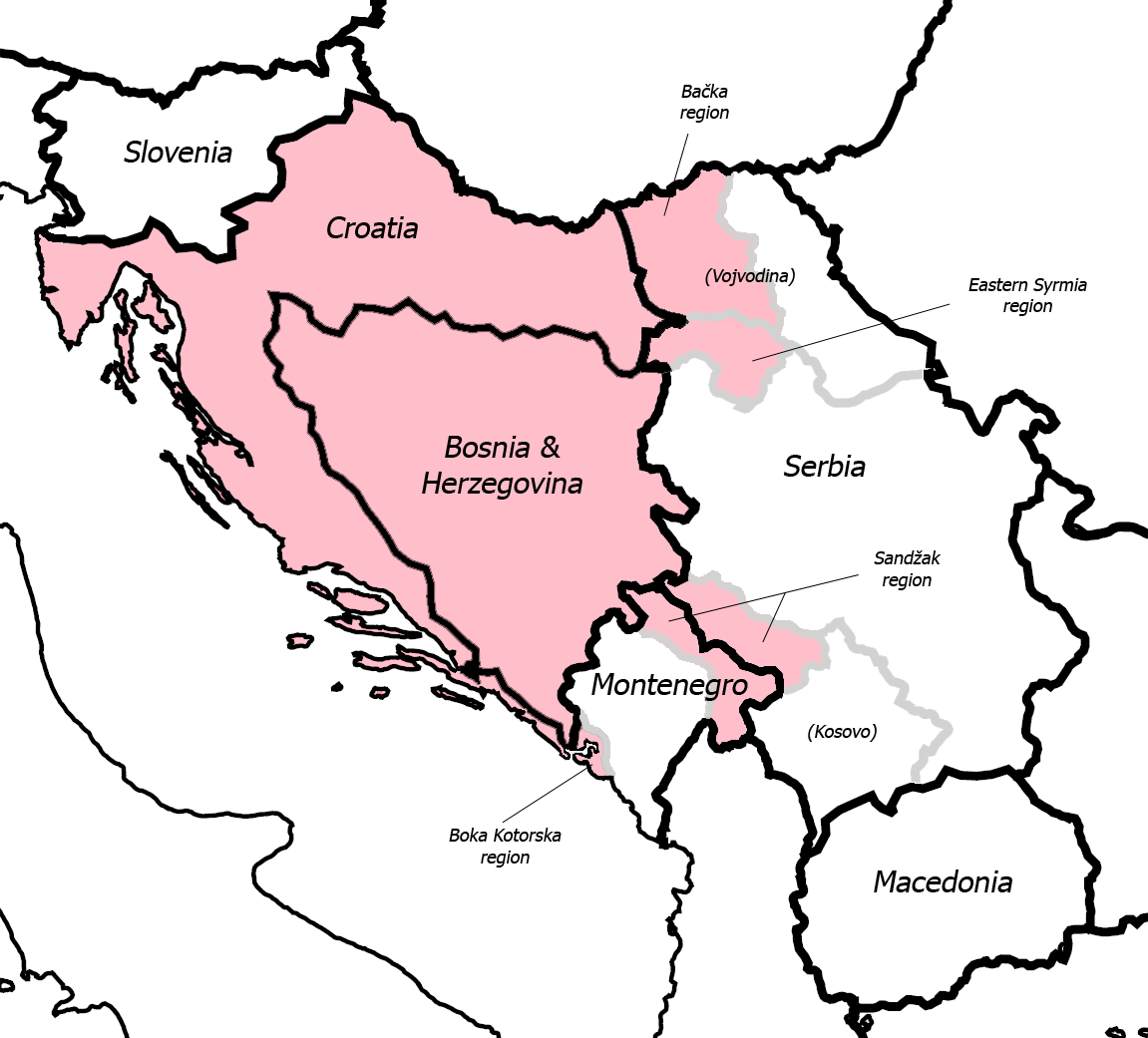
| Περιγραφή |
English: Fixed some detail, used overlaid Sandzak, Backa & Syrmium regions so it's much more accurate now. Pink coloring denotes regions claimed by Greater Croatian proponents. Current country borders are black, regional borders (only those that are relevant to the article) are grey.
CommentMap is still wrong:) Croatian-Slovenian border in Istria is 20 kilometars southern that it should be (Umag and Savudrija are in Croatia, hej!) And borders of eastern Srijem are not correct (Zemun and Novi Beograd are part of Srijem, too).
|
| Ημερομηνία | 24 Μαΐου 2006 (original upload date) |
| Πηγή | Transferred from en.wikipedia to Commons. |
| Δημιουργός | Dr.Gonzo at Αγγλικά Βικιπαίδεια |
| άλλες εκδόσεις |
|


Αδειοδότηση
| Το έργο αυτό έχει απελευθερωθεί στην public domain από τον δημιουργό του, Dr.Gonzo at Αγγλικά Βικιπαίδεια. Αυτό ισχύει σε όλο τον κόσμο. Σε ορισμένες χώρες αυτό μπορεί να μην είναι νομικά εφικτό. Αν ναι: Dr.Gonzo Παραχωρώ σε οποιονδήποτε το δικαίωμα να χρησιμοποιήσει αυτό το έργο "για οποιονδήποτε σκοπό", χωρίς κανέναν όρο, εκτός και αν τέτοιοι όροι τίθενται από την νομοθεσία |
Καταγραφές ανεβασμάτων πρωτότυπου αρχείου
The original description page was here. All following user names refer to en.wikipedia.
- 2007-03-13 10:42 Dr.Gonzo 1151×1041×8 (156832 bytes) Fixed the Istria border (sorry for that, the blank map I used already had that mistake)
- 2006-05-24 22:25 Dr.Gonzo 1151×1041×8 (154088 bytes) Fixed some detail, used overlayed Sandzak, Backa & Syrmium regions so it's much more accurate now.
- 2006-05-24 19:10 Dr.Gonzo 1151×1041×8 (153078 bytes) First version, self made. Some minor geographical detail may be incorrect. Pink coloring denotes regions claimed by Greater Croatian proponents.
Ιστορικό αρχείου
Κλικάρετε σε μια ημερομηνία/ώρα για να δείτε το αρχείο όπως εμφανιζόταν εκείνη τη στιγμή.
| Ώρα/Ημερομ. | Μικρογραφία | Διαστάσεις | Χρήστης | Σχόλια | |
|---|---|---|---|---|---|
| τελευταία | 22:40, 25 Φεβρουαρίου 2008 | | 1.151 × 1.041 (153 KB) | File Upload Bot (Magnus Manske) | {{BotMoveToCommons|en.wikipedia}} {{Information |Description={{en|Fixed some detail, used overlaid Sandzak, Backa & Syrmium regions so it's much more accurate now. Pink coloring denotes regions claimed by Greater Croatian proponents. Current country bord |
Συνδέσεις αρχείου
Τα παρακάτω λήμματα συνδέουν σε αυτό το αρχείο:
Καθολική χρήση αρχείου
Τα ακόλουθα άλλα wiki χρησιμοποιούν αυτό το αρχείο:
- Χρήση σε ar.wikipedia.org
- Χρήση σε bs.wikipedia.org
- Χρήση σε cs.wikipedia.org
- Χρήση σε de.wikipedia.org
- Χρήση σε en.wikipedia.org
- Χρήση σε id.wikipedia.org
- Χρήση σε ja.wikipedia.org
- Χρήση σε pt.wikipedia.org
- Χρήση σε sh.wikipedia.org
- Χρήση σε sr.wikipedia.org
- Χρήση σε uk.wikipedia.org
- Χρήση σε www.wikidata.org