
Αρχείο:Carte des croisades avec participation des Français.png

Εικόνα σε υψηλότερη ανάλυση (1.997 × 1.188 εικονοστοιχεία, μέγεθος αρχείου: 1,65 MB, τύπος MIME: image/png)
|
|
Αυτό το αρχείο και η περιγραφή του προέρχονται από το Wikimedia Commons. Οι πληροφορίες από την σελίδα περιγραφής του εκεί εμφανίζονται παρακάτω. |
Σύνοψη
| Περιγραφή |
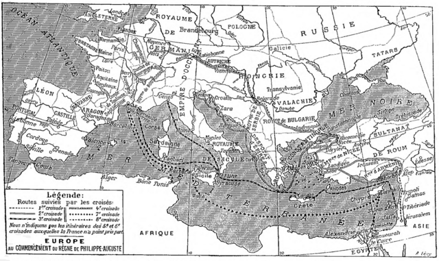
Deutsch: Karte der sechs mittelalterlichen Kreuzzüge, an denen die Franzosen teilgenommen haben, Larousse universel, 1922.
English: Map of the six medieval crusades in which the French participated, from Larousse universel, 1922.
Français : Carte des six croisades médiévales auxquelles les Français ont participé, Larousse universel en deux volumes, 1922. |
| Ημερομηνία | |
| Πηγή | Scan from the Larousse 1922 by Nataraja-Shiva, also available on Gallica |
| Δημιουργός | Larousse |
Αδειοδότηση
|
Αυτό το έργο είναι κοινό κτήμα στη χώρα προέλευσής του και άλλες χώρες και περιοχές όπου η διάρκεια πνευματικών δικαιωμάτων είναι όσο η ζωή του δημιουργού και μέχρι 70 χρόνια μετά ή λιγότερο.
| |
| Αυτό το αρχείο έχει χαρακτηριστεί ως απαλλαγμένο από γνωστούς περιορισμούς βάσει της νομοθεσίας περί πνευματικής ιδιοκτησίας, περιλαμβανομένων όλων των συναφών και συγγενικών δικαιωμάτων. | |
Ιστορικό αρχείου
Κλικάρετε σε μια ημερομηνία/ώρα για να δείτε το αρχείο όπως εμφανιζόταν εκείνη τη στιγμή.
| Ώρα/Ημερομ. | Μικρογραφία | Διαστάσεις | Χρήστης | Σχόλια | |
|---|---|---|---|---|---|
| τελευταία | 14:33, 3 Δεκεμβρίου 2017 | | 1.997 × 1.188 (1,65 MB) | Mélomène | Pologne, Tatars |
| 18:35, 25 Νοεμβρίου 2016 |  | 1.997 × 1.188 (1,65 MB) | Yann | much bigger size | |
| 10:34, 30 Ιανουαρίου 2012 |  | 800 × 486 (485 KB) | Spiridon Ion Cepleanu | Little changes on A. Levy's map since : « Westermann Grosser Atlas zur Weltgeschichte », 1985, ISBN 3-14-100919-8, « DTV Atlas zur Weltgeschichte », 1987, ISBN 2-7242-3596-7, & « Putzger historischer Weltatlas Cornelsen » 1990, ISBN 3-464-0017 | |
| 14:57, 18 Ιανουαρίου 2005 |  | 982 × 597 (179 KB) | Shizhao | from fr |
Συνδέσεις αρχείου
Δεν υπάρχουν σελίδες που συνδέουν σε αυτό το αρχείο.
Καθολική χρήση αρχείου
Τα ακόλουθα άλλα wiki χρησιμοποιούν αυτό το αρχείο:
- Χρήση σε af.wikipedia.org
- Χρήση σε de.wikipedia.org
- Χρήση σε de.wiktionary.org
- Χρήση σε frr.wikipedia.org
- Χρήση σε fr.wikipedia.org
- Χρήση σε fr.wikibooks.org
- Χρήση σε gcr.wikipedia.org
- Χρήση σε ja.wikipedia.org
- Χρήση σε lmo.wikipedia.org
- Χρήση σε mn.wikipedia.org
- Χρήση σε mwl.wikipedia.org
- Χρήση σε oc.wikipedia.org
- Χρήση σε pl.wiktionary.org
- Χρήση σε pt.wikipedia.org
- Χρήση σε zh.wikipedia.org