
Αρχείο:Afghanistan map - security by district and opium poppy cultivation by province 2007 - 2008.png
Afghanistan_map_-_security_by_district_and_opium_poppy_cultivation_by_province_2007_-_2008.png (466 × 330 εικονοστοιχεία, μέγεθος αρχείου: 46 KB, τύπος MIME: image/png)
|
|
Αυτό το αρχείο και η περιγραφή του προέρχονται από το Wikimedia Commons. Οι πληροφορίες από την σελίδα περιγραφής του εκεί εμφανίζονται παρακάτω. |

|
This military map image could be re-created using vector graphics as an SVG file. This has several advantages; see Commons:Media for cleanup for more information. If an SVG form of this image is available, please upload it and afterwards replace this template with
{{vector version available|new image name}}.
It is recommended to name the SVG file “Afghanistan map - security by district and opium poppy cultivation by province 2007 - 2008.svg”—then the template Vector version available (or Vva) does not need the new image name parameter. |
Σύνοψη
| Περιγραφή |
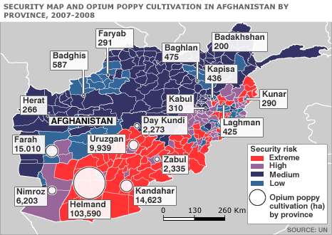
English: Map of Afghanistan showing the security situation by district and opium cultivation by province in the period 2007 to 2008. |
| Ημερομηνία | |
| Πηγή | http://news.bbc.co.uk/2/hi/south_asia/7663204.stm |
| Δημιουργός | United Nations Department of Safety and Security |
Αδειοδότηση
| This image is a map derived from a United Nations map.
Unless stated otherwise, UN maps are to be considered in the public domain. This applies worldwide. UN maps are, in principle, open source material and you can use them in your work or for making your own map. UN requests however that you delete the UN name, logo and reference number upon any modification to the map. Content of your map will be your responsibility. You can state in your publication, if you wish, something like: based on UN map … (map name, map number, revision number and date). See: Geospatial Information Section. And: Geospatial, location data for a better world. |
 |
Καταγραφές ανεβασμάτων πρωτότυπου αρχείου
| Ημερομηνία/Ώρα | Διαστάσεις | Χρήστης | Σχόλιο |
|---|---|---|---|
| 11 Οκτωβρίου 2008, 06:52:24 | 466 × 330 (41766 bytes) | Le Behnam (συζήτηση · Συνεισφορά) | {{Information |Description={{en|1=Map of Afghanistan showing the security situation by district and opium cultivation by province in the period 2007 to 2008.}} |Source=http://news.bbc.co.uk/2/hi/south_asia/7663204.stm |Author=United Nations Department of |
Ιστορικό αρχείου
Κλικάρετε σε μια ημερομηνία/ώρα για να δείτε το αρχείο όπως εμφανιζόταν εκείνη τη στιγμή.
| Ώρα/Ημερομ. | Μικρογραφία | Διαστάσεις | Χρήστης | Σχόλια | |
|---|---|---|---|---|---|
| τελευταία | 15:54, 10 Αυγούστου 2014 | | 466 × 330 (46 KB) | GifTagger | Bot: Converting file to superior PNG file. (Source: [[File:Afghanistan_map_-_security_by_district_and_opium_poppy_cultivation_by_province_2007_-_2008.gif|Afghanistan_map_-_security_by_district_and_opium_poppy_cultivation_by_province... |
Συνδέσεις αρχείου
Τα παρακάτω λήμματα συνδέουν σε αυτό το αρχείο:
Καθολική χρήση αρχείου
Τα ακόλουθα άλλα wiki χρησιμοποιούν αυτό το αρχείο:
- Χρήση σε ar.wikipedia.org
- Χρήση σε ca.wikipedia.org
- Χρήση σε ce.wikipedia.org
- Χρήση σε en.wikipedia.org
- Χρήση σε fr.wikipedia.org
- Χρήση σε hu.wikipedia.org
- Χρήση σε ja.wikipedia.org
- Χρήση σε nl.wikipedia.org
- Χρήση σε pt.wikipedia.org
- Χρήση σε ro.wikipedia.org
- Χρήση σε ru.wikipedia.org
- Χρήση σε www.wikidata.org