
Αρχείο:1943 World War II Japanese Aeronautical Map of Borneo - Geographicus - Borneo12-wwii-1943.jpg

Εικόνα σε υψηλότερη ανάλυση (5.000 × 3.397 εικονοστοιχεία, μέγεθος αρχείου: 5,27 MB, τύπος MIME: image/jpeg)
|
|
Αυτό το αρχείο και η περιγραφή του προέρχονται από το Wikimedia Commons. Οι πληροφορίες από την σελίδα περιγραφής του εκεί εμφανίζονται παρακάτω. |
| Borneo | |||||
|---|---|---|---|---|---|
| Καλλιτέχνης | |||||
| Τίτλος |
Borneo |
||||
| Περιγραφή |
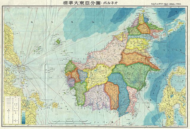
English: A stunning large format Japanese map of Borneo dating to World War II. Covers the entirety of the island with color coding according to district. Offers superb detail regarding both topographical and political elements. Notes cities, roads, trade routes on air, sea and land, and uses shading to display oceanic depths. All text in Japanese. While Allied World War II maps of this region are fairly common it is extremely rare to come across their Japanese counterparts. This map was created as map no. 12 of a 20 map series detailing of parts of Asia and the Pacific prepared by the Japanese during World War II. |
||||
| Ημερομηνία | 1943 (undated) | ||||
| Διαστάσεις | ύψος: 20 ίντσες (50,8 cm)• πλάτος: 29 ίντσες (73,6 cm) | ||||
| Αριθμός καταχώρησης |
Geographicus link: Borneo12-wwii-1943 |
||||
| Πηγή/φωτογράφος |
|
||||
| Άδεια (Επαναχρησιμοποίηση αυτού του αρχείου) |
|
||||

Ιστορικό αρχείου
Κλικάρετε σε μια ημερομηνία/ώρα για να δείτε το αρχείο όπως εμφανιζόταν εκείνη τη στιγμή.
| Ώρα/Ημερομ. | Μικρογραφία | Διαστάσεις | Χρήστης | Σχόλια | |
|---|---|---|---|---|---|
| τελευταία | 16:50, 22 Μαρτίου 2011 | | 5.000 × 3.397 (5,27 MB) | BotMultichillT | {{subst:User:Multichill/Geographicus |link=http://www.geographicus.com/P/AntiqueMap/Borneo12-wwii-1943 |product_name=1943 World War II Japanese Aeronautical Map of Borneo |map_title=Borneo |description=A stunning large format Japanese map of Borneo dating |
Συνδέσεις αρχείου
Καθολική χρήση αρχείου
Τα ακόλουθα άλλα wiki χρησιμοποιούν αυτό το αρχείο:
- Χρήση σε ar.wikipedia.org
- Χρήση σε en.wikipedia.org
- Χρήση σε es.wikipedia.org
- Χρήση σε fa.wikipedia.org
- Χρήση σε fr.wikipedia.org
- Χρήση σε id.wikipedia.org
- Χρήση σε ja.wikipedia.org
- Χρήση σε ms.wikipedia.org
- Χρήση σε my.wikipedia.org
- Χρήση σε ru.wikipedia.org
- Χρήση σε ta.wikipedia.org
- Χρήση σε www.wikidata.org
- Χρήση σε zh.wikipedia.org