
Αρχείο:1776 Rennell - Dury Wall Map of Bihar and Bengal, India - Geographicus - BaharBengal-dury-1776.jpg

Εικόνα σε υψηλότερη ανάλυση (9.106 × 6.000 εικονοστοιχεία, μέγεθος αρχείου: 16,86 MB, τύπος MIME: image/jpeg)
|
|
Αυτό το αρχείο και η περιγραφή του προέρχονται από το Wikimedia Commons. Οι πληροφορίες από την σελίδα περιγραφής του εκεί εμφανίζονται παρακάτω. |
Σύνοψη
| Προσοχή | Μερικοί φυλλομετρητές ίσως αντιμετωπίσουν πρόβλημα με την απεικόνιση αυτής της εικόνας σε πλήρη ανάλυση: Αυτή η εικόνα έχει πολύ μεγάλο αριθμό πίξελς και μπορεί είτε να μη φορτωθεί κανονικά είτε ο φυλλομετρητής να κολλήσει. |
|---|
| Τίτλος |
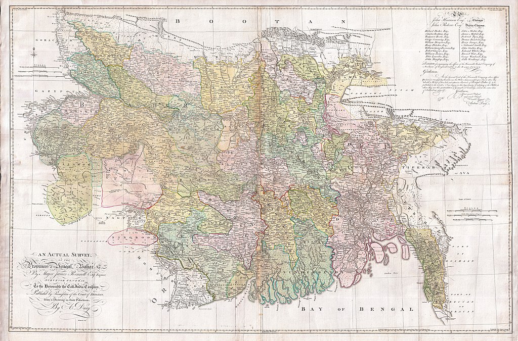
An Actual Survey, of the Provinces of Bengal, Bahar & c. by Major James Rennell Esq. Engineer to the Honorable the East India Company. Published by Permission of the Court of Directors from a Drawing in their Possession by A. Dury. |
|||||||||
| Περιγραφή |
English: An altogether spectacular wall sized map of those parts of Bengal and Bihar, India. Follows the course of the Ganges River from Varanasi (Benares) eastward to the Ganges Delta and the Bay of Bengal. Includes Varanasi (Benares), Dacca (Dahka, Bengladesh), and Patna among many other important Indian cities. Bounded on the north by the Himalaya Mountains and the border with Bhutan. One of the first accurate maps of the interior of India. Laid out from primary surveys done by James Rennell, the first modern cartographer to map the interior of India. Notes cities, markets, battlefields, fortresses, roads, rivers, offers political commentary, and features some geographical references. Elaborate title in the lower left quadrant. Upper right quadrant features a dedication and letter of thanks written by Andrew Dury, the publisher, to the board of the East India Company. This is the first edition of this rare map – 1776 – as published by Dury. Later editions were published by Sayer and Bennet and by Laurie and Whittle.
Another high quality digitisation is available at the David Rumsey Historical Map Collection: [1] This map was published by Laurie and Whittle, as mentioned in the description by Geographicus for the 1776 map, in 1794. Regions are demarcated in coloured outlines instead of filled colours. A higher quality digitisation than that of Geographicus. Contains parts that are missing at the central vertical fold in the Geographicus digitisation of the 1776 map. Viewable in online Flash viewer and downloadable in MrSID format. |
|||||||||
| Ημερομηνία | (dated) | |||||||||
| Πηγή |
The Bengal Atlas ??, Rennell, James, (1779 first edition)
|
|||||||||
| Δημιουργός | ||||||||||
| Geotemporal data | ||||||||||
| Bounding box |
|
|||||||||
| Georeferencing | ||||||||||
| Archival data | ||||||||||
| Αριθμός καταχώρησης |
Geographicus link: BaharBengal-dury-1776 |
|||||||||
| Διαστάσεις | ύψος: 39 ίντσες (99 cm)• πλάτος: 59 ίντσες (149,8 cm) | |||||||||

|
This image has been assessed under the valued image criteria and is considered the most valued image on Commons within the scope: Old maps of Bengal from 1776 by Major James Rennell. You can see its nomination here. |
Αδειοδότηση
|
Αυτό το έργο είναι κοινό κτήμα στη χώρα προέλευσής του και άλλες χώρες και περιοχές όπου η διάρκεια πνευματικών δικαιωμάτων είναι όσο η ζωή του δημιουργού και μέχρι 100 χρόνια μετά ή λιγότερο. Αυτό το έργο είναι κοινό κτήμα στις Ηνωμένες Πολιτείες επειδή δημοσιεύτηκε (ή καταχωρήθηκε στο U.S. Copyright Office) πριν την 1 Ιανουαρίου 1929. | |
| Αυτό το αρχείο έχει χαρακτηριστεί ως απαλλαγμένο από γνωστούς περιορισμούς βάσει της νομοθεσίας περί πνευματικής ιδιοκτησίας, περιλαμβανομένων όλων των συναφών και συγγενικών δικαιωμάτων. | |
Ιστορικό αρχείου
Κλικάρετε σε μια ημερομηνία/ώρα για να δείτε το αρχείο όπως εμφανιζόταν εκείνη τη στιγμή.
| Ώρα/Ημερομ. | Μικρογραφία | Διαστάσεις | Χρήστης | Σχόλια | |
|---|---|---|---|---|---|
| τελευταία | 08:39, 17 Μαρτίου 2011 | | 9.106 × 6.000 (16,86 MB) | BotMultichill | {{subst:User:Multichill/Geographicus |link=http://www.geographicus.com/P/AntiqueMap/BaharBengal-dury-1776 |product_name=1776 Rennell - Dury Wall Map of Bihar and Bengal, India |map_title=An Actual Survey, of the Provinces of Bengal, Bahar & c. by Major Ja |
Συνδέσεις αρχείου
Τα παρακάτω λήμματα συνδέουν σε αυτό το αρχείο:
Καθολική χρήση αρχείου
Τα ακόλουθα άλλα wiki χρησιμοποιούν αυτό το αρχείο:
- Χρήση σε ar.wikipedia.org
- Χρήση σε as.wikipedia.org
- Χρήση σε azb.wikipedia.org
- Χρήση σε bn.wikipedia.org
- Χρήση σε bn.wikisource.org
- Χρήση σε cs.wikipedia.org
- Χρήση σε en.wikipedia.org
- Χρήση σε es.wikipedia.org
- Χρήση σε fa.wikipedia.org
- Χρήση σε fr.wikipedia.org
- Χρήση σε hi.wikipedia.org
- Χρήση σε ja.wikipedia.org
- Χρήση σε ko.wikipedia.org
- Χρήση σε ml.wikipedia.org
- Χρήση σε mt.wikipedia.org
- Χρήση σε ne.wikipedia.org
- Χρήση σε nl.wikipedia.org
- Χρήση σε pnb.wikipedia.org
- Χρήση σε sa.wikipedia.org
Δείτε περισσότερη καθολική χρήση αυτού του αρχείου.