
Αρχείο:ShepherdByzempire1265.jpg
Εικόνα σε υψηλότερη ανάλυση (1.144 × 900 εικονοστοιχεία, μέγεθος αρχείου: 281 KB, τύπος MIME: image/jpeg)
|
|
Αυτό το αρχείο και η περιγραφή του προέρχονται από το Wikimedia Commons. Οι πληροφορίες από την σελίδα περιγραφής του εκεί εμφανίζονται παρακάτω. |
Σύνοψη
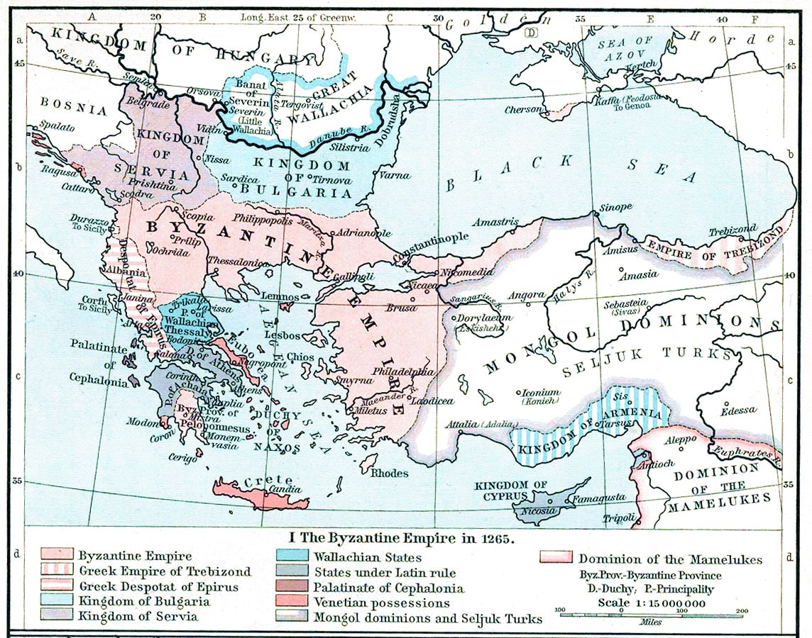
| Περιγραφή | Map, The Byzantine Empire, 1265. | ||||||||||||||||||||||
| Ημερομηνία | |||||||||||||||||||||||
| Πηγή | The Historical Atlas, William R. Shepherd, 1911. | ||||||||||||||||||||||
| Δημιουργός |
|
||||||||||||||||||||||
| άλλες εκδόσεις |
Derivative works of this file: |
||||||||||||||||||||||

|
This old map image could be re-created using vector graphics as an SVG file. This has several advantages; see Commons:Media for cleanup for more information. If an SVG form of this image is available, please upload it and afterwards replace this template with
{{vector version available|new image name}}.
It is recommended to name the SVG file “ShepherdByzempire1265.svg”—then the template Vector version available (or Vva) does not need the new image name parameter. |


Αδειοδότηση
|
Αυτό το έργο είναι κοινό κτήμα στη χώρα προέλευσής του και άλλες χώρες και περιοχές όπου η διάρκεια πνευματικών δικαιωμάτων είναι όσο η ζωή του δημιουργού και μέχρι 70 χρόνια μετά ή λιγότερο.
| |
| Αυτό το αρχείο έχει χαρακτηριστεί ως απαλλαγμένο από γνωστούς περιορισμούς βάσει της νομοθεσίας περί πνευματικής ιδιοκτησίας, περιλαμβανομένων όλων των συναφών και συγγενικών δικαιωμάτων. | |
This media file is in the public domain in the United States. This applies to U.S. works where the copyright has expired, often because its first publication occurred prior to January 1, 1929, and if not then due to lack of notice or renewal. See this page for further explanation.
|
 | |
 |
This image might not be in the public domain outside of the United States; this especially applies in the countries and areas that do not apply the rule of the shorter term for US works, such as Canada, Mainland China (not Hong Kong or Macao), Germany, Mexico, and Switzerland. The creator and year of publication are essential information and must be provided. See Wikipedia:Public domain and Wikipedia:Copyrights for more details.
|
Ιστορικό αρχείου
Κλικάρετε σε μια ημερομηνία/ώρα για να δείτε το αρχείο όπως εμφανιζόταν εκείνη τη στιγμή.
| Ώρα/Ημερομ. | Μικρογραφία | Διαστάσεις | Χρήστης | Σχόλια | |
|---|---|---|---|---|---|
| τελευταία | 15:28, 16 Νοεμβρίου 2022 | | 1.144 × 900 (281 KB) | Gyalu22 | Reverted to version as of 16:26, 12 July 2009 (UTC) |
| 14:49, 20 Μαΐου 2016 |  | 1.144 × 900 (858 KB) | Julieta39 | Cosmetic (see discussion file) | |
| 16:26, 12 Ιουλίου 2009 |  | 1.144 × 900 (281 KB) | Alex:D | whitened | |
| 16:17, 12 Ιουλίου 2009 |  | 1.144 × 900 (281 KB) | Alex:D | whitened | |
| 16:12, 12 Ιουλίου 2009 |  | 1.144 × 900 (281 KB) | Alex:D | whitened | |
| 13:40, 21 Δεκεμβρίου 2004 |  | 1.144 × 900 (272 KB) | Mschlindwein | Map, The Byzantine Empire, 1265. The Historical Atlas, William R. Shepherd, 1911. |
Συνδέσεις αρχείου
Τα παρακάτω λήμματα συνδέουν σε αυτό το αρχείο:
Καθολική χρήση αρχείου
Τα ακόλουθα άλλα wiki χρησιμοποιούν αυτό το αρχείο:
- Χρήση σε an.wikipedia.org
- Χρήση σε ar.wikipedia.org
- Χρήση σε azb.wikipedia.org
- Χρήση σε az.wikipedia.org
- Χρήση σε be-tarask.wikipedia.org
- Χρήση σε be.wikipedia.org
- Χρήση σε bg.wikipedia.org
- Χρήση σε ca.wikipedia.org
- Χρήση σε cs.wikipedia.org
- Χρήση σε de.wikipedia.org
- Χρήση σε en.wikipedia.org
- 1265
- Naxos
- Michael VIII Palaiologos
- Theodore II Laskaris
- Morea
- Duchy of the Archipelago
- Battle of Pelagonia
- Wikipedia:Today's featured article/April 2004
- Wikipedia:Today's featured article/April 1, 2004
- User:Rfl/FeaturedArticle
- Great Vlachia
- Kingdom of Albania (medieval)
- Talk:Cetina
- John Palaiologos (brother of Michael VIII)
- Byzantine–Mongol Alliance
- History of the Byzantine Empire
- Treaty of Nymphaeum (1261)
- Battle of Pharsalus (1277)
- Siege of Berat (1280–1281)
Δείτε περισσότερη καθολική χρήση αυτού του αρχείου.