
Αρχείο:Portugalliae 1561 (Baseado no primeiro mapa de Portugal)-JM.jpg

Εικόνα σε υψηλότερη ανάλυση (6.048 × 4.120 εικονοστοιχεία, μέγεθος αρχείου: 8,4 MB, τύπος MIME: image/jpeg)
|
|
Αυτό το αρχείο και η περιγραφή του προέρχονται από το Wikimedia Commons. Οι πληροφορίες από την σελίδα περιγραφής του εκεί εμφανίζονται παρακάτω. |
Σύνοψη
- From portuguese wikipedia José Manuel CH--GE 14:34, 9 Novembro 2005 (UTC)
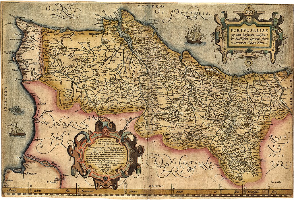
| Περιγραφή |
English: Portugalliae que olim Lusitania, novissima & exactissima descriptio. [1] Adaptation in the "Theatrum Orbis Terrarum" (1570) de Abraham Ortelius from the alleged first map of Portugal (1560) by Álvaro Seco. Português: Portugalliae que olim Lusitania, novissima & exactissima descriptio. [2] é provavelmente o primeiro mapa de Portugal. Feito por Álvaro Seco é provavelmente publicado em Roma por volta de 1560 com o título "Tabula Geografica Portugalliae". |
| Ημερομηνία | |
| Πηγή | Έργο αυτού που το ανεβάζει |
| Δημιουργός | Jose Manuel |
| άλλες εκδόσεις |
|
-JM_(pormenor_com_Troia).jpg)
_-_Geographicus_-_Portugalliae-ortelius-1587.jpg)


-JM.jpg?uselang=el)
Αδειοδότηση
|
Αυτό το έργο είναι κοινό κτήμα στη χώρα προέλευσής του και άλλες χώρες και περιοχές όπου η διάρκεια πνευματικών δικαιωμάτων είναι όσο η ζωή του δημιουργού και μέχρι 70 χρόνια μετά ή λιγότερο.
| |
| Αυτό το αρχείο έχει χαρακτηριστεί ως απαλλαγμένο από γνωστούς περιορισμούς βάσει της νομοθεσίας περί πνευματικής ιδιοκτησίας, περιλαμβανομένων όλων των συναφών και συγγενικών δικαιωμάτων. | |
Ιστορικό αρχείου
Κλικάρετε σε μια ημερομηνία/ώρα για να δείτε το αρχείο όπως εμφανιζόταν εκείνη τη στιγμή.
| Ώρα/Ημερομ. | Μικρογραφία | Διαστάσεις | Χρήστης | Σχόλια | |
|---|---|---|---|---|---|
| τελευταία | 06:01, 13 Δεκεμβρίου 2018 | | 6.048 × 4.120 (8,4 MB) | SteinsplitterBot | Bot: Image rotated by 90° |
| 00:34, 11 Αυγούστου 2012 |  | 4.120 × 6.054 (8,42 MB) | Jose Manuel | Best vertical photo resolution and sharp | |
| 23:04, 10 Αυγούστου 2012 |  | 6.054 × 4.120 (21,47 MB) | Jose Manuel | Best photo resolution and sharp | |
| 15:26, 9 Νοεμβρίου 2005 |  | 403 × 600 (94 KB) | Nuno Tavares | ;'''Description:''' :{{português}}: '' Portugalliae 1561 (Baseado no primeiro mapa de Portugal) " ;'''Source/Credits:''' : {{português}}: Fotografias Imagens ilustrações do usuário registrado. (''Não protegidos por copyright''). <br> :: Igualmente p |
Συνδέσεις αρχείου
Δεν υπάρχουν σελίδες που συνδέουν σε αυτό το αρχείο.
Καθολική χρήση αρχείου
Τα ακόλουθα άλλα wiki χρησιμοποιούν αυτό το αρχείο:
- Χρήση σε an.wikipedia.org
- Χρήση σε azb.wikipedia.org
- Χρήση σε be.wikipedia.org
- Χρήση σε ca.wikipedia.org
- Χρήση σε cs.wikipedia.org
- Χρήση σε de.wikipedia.org
- Χρήση σε en.wikipedia.org
- Χρήση σε eo.wikipedia.org
- Χρήση σε es.wikipedia.org
- Χρήση σε eu.wikipedia.org
- Χρήση σε fr.wikipedia.org
- Χρήση σε ga.wikipedia.org
- Χρήση σε gl.wikipedia.org
- Χρήση σε id.wikipedia.org
- Χρήση σε it.wikipedia.org
- Χρήση σε ml.wikipedia.org
- Χρήση σε ms.wikipedia.org
- Χρήση σε nl.wikipedia.org
- Χρήση σε nn.wikipedia.org
- Χρήση σε oc.wikipedia.org
- Χρήση σε pl.wikipedia.org
- Χρήση σε pt.wikipedia.org
- Χρήση σε ru.wikipedia.org
- Χρήση σε sk.wikipedia.org
- Χρήση σε sv.wikipedia.org
- Χρήση σε uk.wikipedia.org
- Χρήση σε vi.wikipedia.org
- Χρήση σε www.wikidata.org
- Χρήση σε zh.wikipedia.org
-JM.jpg)