
Αρχείο:Austria satellite-map.jpg

Εικόνα σε υψηλότερη ανάλυση (2.550 × 1.381 εικονοστοιχεία, μέγεθος αρχείου: 1,22 MB, τύπος MIME: image/jpeg)
|
|
Αυτό το αρχείο και η περιγραφή του προέρχονται από το Wikimedia Commons. Οι πληροφορίες από την σελίδα περιγραφής του εκεί εμφανίζονται παρακάτω. |
Σύνοψη
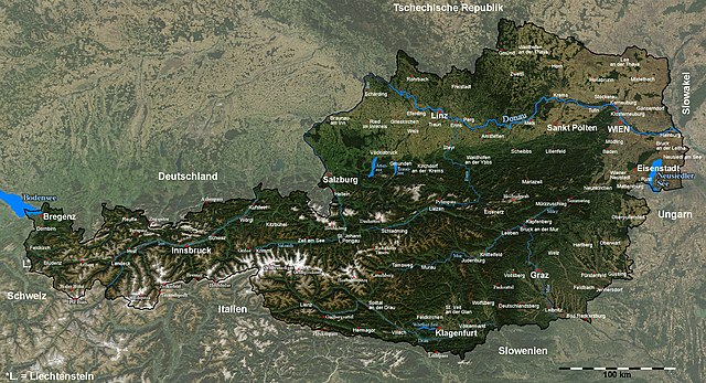
| Περιγραφή | Satellite image of Austria with provincial capitals and other annotations |
| Ημερομηνία | |
| Πηγή |
The image is based on a satellite image from [1]. Original image: Credit Jeff Schmaltz, MODIS Rapid Response Team, NASA/GSFC. |
| Δημιουργός | Michael Schmid |
| Άδεια (Επαναχρησιμοποίηση αυτού του αρχείου) |
Based on a NASA image, thus in the public domain. |
| άλλες εκδόσεις | Image:Austria_satellite_unannotated.jpg with no annotations except dots at the positions of a few cities, Image:Austria_satellite_annotated.jpg with some limited annotations. |
![[1]](http://visibleearth.nasa.gov/images/5947/Italy.A2003262.1005.250m.jpg)
I have marked and labelled quite a lot of places with the help of the NASA Worldwind software and several maps. It was quite some work, but also a nice exercise in geography for me ;-).
Unless I have forgotten something, the map shows (among other cities) the capitals of all districts and provinces of Austria.
Please note: The cities of Wien (Vienna) and Linz were marked a few kilometers from their actual locations in the original satellite image; this has been corrected here.[2].
Das Bild wurde in y-Richtung um ca. 5% gestreckt, um eine wenig verzerrte Karte zu erhalten. Um Österreich hervorzuheben, habe ich den Kontrast außerhalb der Grenzen Österreichs reduziert und die Grenzlinie dicker eingezeichnet, und danach durch Vergleich mit der NASA Worldwind Software und diversen Karten die Positionen diverser Orte, Berge und Pässe bestimmt und eingezeichnet.
Die Karte enthält (wenn ich keine vergessen habe) unter anderem alle Landes- und Bezirkshauptstädte Österreichs.Αδειοδότηση
| Αυτό το αρχείο είναι κοινό κτήμα γιατί δημιουργήθηκε από την NASA. Η πολιτική πνευματικής ιδιοκτησίας της NASA δηλώνει ότι «Το υλικό της NASA δεν προστατεύεται από copyright εκτός αν αναφέρεται». (Σελίδα με την πολιτική πνευματικής ιδιοκτησίας της NASA ή Πολιτική Χρήσης Εικόνων του JPL). | ||
 |
Προσοχή:
|
Ιστορικό αρχείου
Κλικάρετε σε μια ημερομηνία/ώρα για να δείτε το αρχείο όπως εμφανιζόταν εκείνη τη στιγμή.
| Ώρα/Ημερομ. | Μικρογραφία | Διαστάσεις | Χρήστης | Σχόλια | |
|---|---|---|---|---|---|
| τελευταία | 19:41, 11 Σεπτεμβρίου 2005 | | 2.550 × 1.381 (1,22 MB) | Schmid | {{Information| |Description = Satellite image of Austria with provincial capitals and other annotations | Source = The image is based on a satellite image from [http://visibleearth.nasa.gov/images/5947/Italy.A2003262.1005.250m.jpg]. Original image: Cre |
Συνδέσεις αρχείου
Δεν υπάρχουν σελίδες που συνδέουν σε αυτό το αρχείο.
Καθολική χρήση αρχείου
Τα ακόλουθα άλλα wiki χρησιμοποιούν αυτό το αρχείο:
- Χρήση σε af.wikipedia.org
- Χρήση σε cs.wikipedia.org
- Χρήση σε da.wikipedia.org
- Χρήση σε de.wikipedia.org
- Χρήση σε en.wikipedia.org
- Χρήση σε fr.wikipedia.org
- Χρήση σε hu.wikipedia.org
- Χρήση σε hy.wikipedia.org
- Χρήση σε hyw.wikipedia.org
- Χρήση σε ku.wikipedia.org
- Χρήση σε nn.wikipedia.org
- Χρήση σε no.wikipedia.org
- Χρήση σε rm.wikipedia.org
- Χρήση σε ru.wikipedia.org
- Χρήση σε sk.wikipedia.org
- Χρήση σε tl.wikipedia.org
- Χρήση σε tr.wikipedia.org
- Χρήση σε uk.wikipedia.org