
Αρχείο:Albania kosovo macedonia 6 8 century.png
Μέγεθος αυτής της προεπισκόπησης: 370 × 600 εικονοστοιχεία . Άλλες αναλύσεις: 148 × 240 εικονοστοιχεία | 597 × 968 εικονοστοιχεία.
Εικόνα σε υψηλότερη ανάλυση (597 × 968 εικονοστοιχεία, μέγεθος αρχείου: 55 KB, τύπος MIME: image/png)
|
|
Αυτό το αρχείο και η περιγραφή του προέρχονται από το Wikimedia Commons. Οι πληροφορίες από την σελίδα περιγραφής του εκεί εμφανίζονται παρακάτω. |
Σύνοψη
| Περιγραφή |
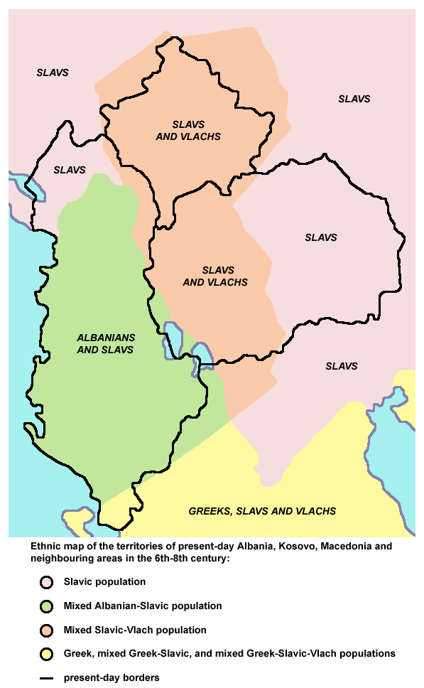
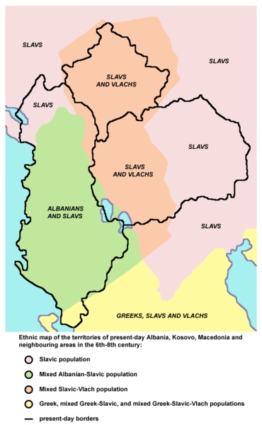
English: Ethnic map of the territories of present-day Albania, Kosovo, Macedonia and neighbouring areas in the 6th-8th century (according to the historical atlas for schools, published in Belgrade in 1970, representing a view of Yugoslav historians from that time). |
| Πηγή | Έργο αυτού που το ανεβάζει |
| Δημιουργός | PANONIAN |
Αδειοδότηση
| Εγώ, ο κάτοχος των πνευματικών δικαιωμάτων αυτού του έργου, δημοσιεύω αυτό το έργο ως κοινό κτήμα. Αυτό ισχύει σε παγκόσμια κλίμακα. Σε ορισμένες χώρες αυτό μπορεί να μην είναι νομικά εφικτό. Αν ναι: Παραχωρώ σε οποιονδήποτε το δικαίωμα να χρησιμοποιήσει αυτό το έργο "για οποιονδήποτε σκοπό", χωρίς κανέναν όρο, εκτός και αν τέτοιοι όροι τίθενται από την νομοθεσία |
References
Main reference:
- Created according to the historical map from this history atlas: "Školski istorijski atlas, Zavod za izdavanje udžbenika SR Srbije, Beograd, 1970."
Secondary references (with similar maps):
- The Times - Atlas Svjetske Povijesti, Dopunjeno izdanje za Jugoslaviju, Cankarjeva založba, Ljubljana, 1986. - this is Yugoslav (Serbo-Croatian) edition of this original source: The Times Atlas of World History, Times Books Limited, London, 1984. (in Yugoslav version from 1986 there is similar map on page number 298)
- Denis Šehić - Demir Šehić, Istorijski atlas Sveta, Beograd, 2007. (similar map is published on page number 29)
- Istorijski atlas, Geokarta, Beograd, 1999. (similar map is published on page number 33)
- The former Yugoslavia's diverse peoples: a reference sourcebook By Matjaž Klemenčič, Mitja Žagar: https://books.google.com/books?id=ORSMBFwjAKcC&pg=PA3&lpg=PA5&vq=maps&output=html (a source with similar map published on page number 3)
- Here is an external link with similar map: http://www.camo.ch/illiricum7.htm archive copy at the Wayback Machine
Ιστορικό αρχείου
Κλικάρετε σε μια ημερομηνία/ώρα για να δείτε το αρχείο όπως εμφανιζόταν εκείνη τη στιγμή.
| Ώρα/Ημερομ. | Μικρογραφία | Διαστάσεις | Χρήστης | Σχόλια | |
|---|---|---|---|---|---|
| τελευταία | 20:27, 21 Σεπτεμβρίου 2013 | | 597 × 968 (55 KB) | PANONIAN | aesthetics |
| 18:56, 7 Φεβρουαρίου 2010 |  | 598 × 964 (55 KB) | PANONIAN | {{Information |Description={{en|1=Ethnic map of the territories of present-day Albania, Kosovo, Macedonia and neighbouring areas in the 6th-8th century.}} |Source={{own}} |Author=PANONIAN |Date= |Permission= |other_versions= }} |
Συνδέσεις αρχείου
Δεν υπάρχουν σελίδες που συνδέουν σε αυτό το αρχείο.
Καθολική χρήση αρχείου
Τα ακόλουθα άλλα wiki χρησιμοποιούν αυτό το αρχείο:
- Χρήση σε hr.wikipedia.org
- Χρήση σε hu.wikipedia.org
- Χρήση σε mk.wikipedia.org
- Χρήση σε pl.wikipedia.org
- Χρήση σε sr.wikipedia.org