
Αρχείο:Administrative division of denmark in medieval times.jpg
Εικόνα σε υψηλότερη ανάλυση (5.952 × 4.336 εικονοστοιχεία, μέγεθος αρχείου: 15,8 MB, τύπος MIME: image/jpeg)
|
|
Αυτό το αρχείο και η περιγραφή του προέρχονται από το Wikimedia Commons. Οι πληροφορίες από την σελίδα περιγραφής του εκεί εμφανίζονται παρακάτω. |
Σύνοψη
| Περιγραφή |
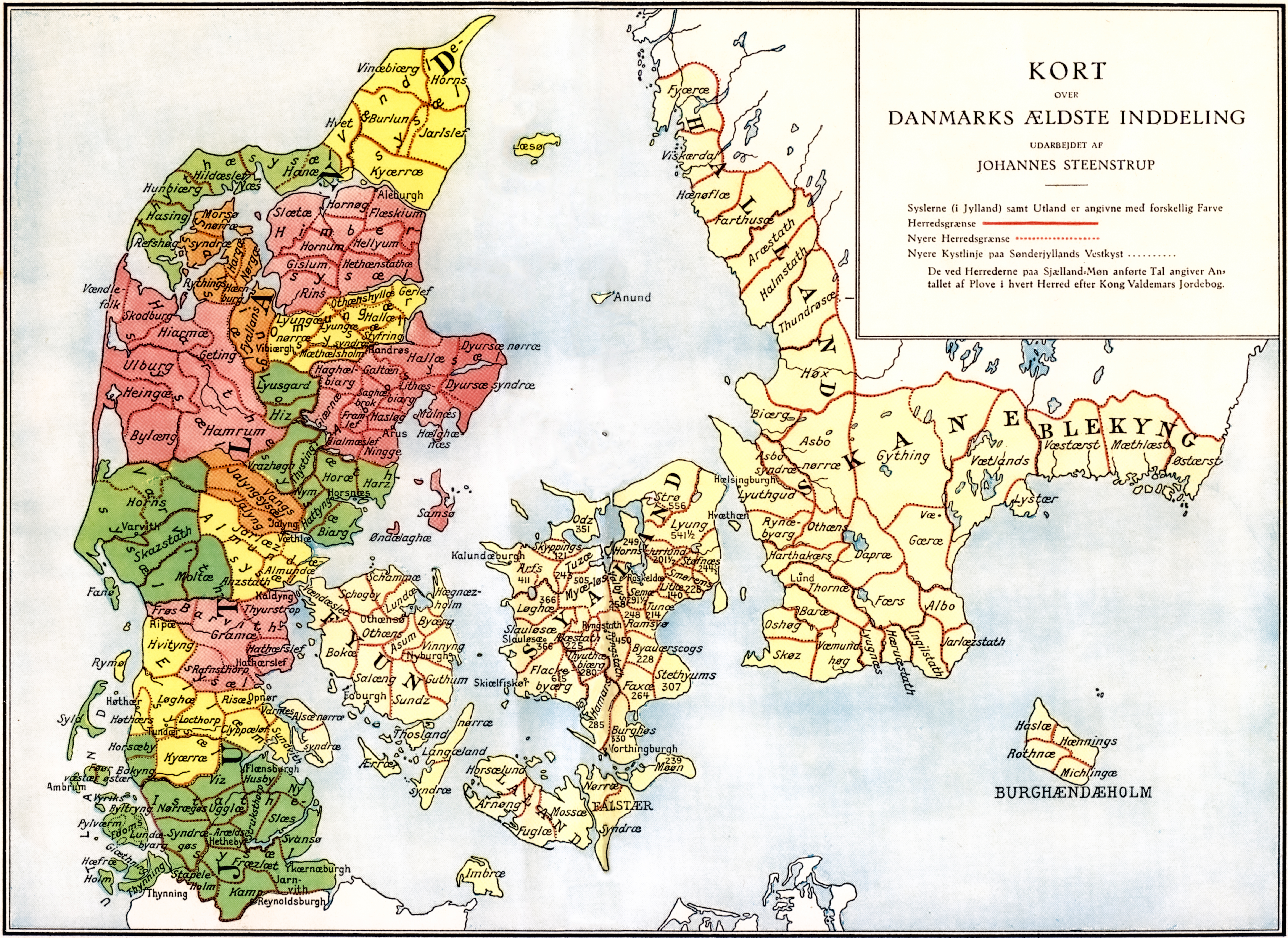
Administrative division of Denmark in Medieval times. |
||||||||||||||||||||
| Map legend | The different colors indicate the division in sysler in Jutland while the red lines indicate borders between herreder (hundreds). Dotted red lines indicate newer borders. Note:The purely ecclesiastic sysler on Zealand are not included on this map. | ||||||||||||||||||||
| Πηγή | The map was made by professor Johannes Steenstrup (died 1935) for use in Danmarks Riges Historie (1900, after page 625) and is in Public Domain since Steenstrup died more than 70 years ago. | ||||||||||||||||||||
| Δημιουργός |
|
||||||||||||||||||||
| Άδεια (Επαναχρησιμοποίηση αυτού του αρχείου) |
|
||||||||||||||||||||
| Georeferencing | If inappropriate please set warp_status = skip to hide. | ||||||||||||||||||||
| άλλες εκδόσεις | |||||||||||||||||||||


.jpg)

.jpg)
.jpg)
.jpg)
.jpg)
.jpg)
.jpg)
.jpg)
.jpg)
.jpg)
.jpg)
.jpg)
.jpg)


.jpg)
Ιστορικό αρχείου
Κλικάρετε σε μια ημερομηνία/ώρα για να δείτε το αρχείο όπως εμφανιζόταν εκείνη τη στιγμή.
| Ώρα/Ημερομ. | Μικρογραφία | Διαστάσεις | Χρήστης | Σχόλια | |
|---|---|---|---|---|---|
| τελευταία | 16:30, 12 Ιουνίου 2019 | | 5.952 × 4.336 (15,8 MB) | Aeroid | removed vertical lines, straight, slight color change |
| 05:36, 19 Ιουνίου 2005 |  | 5.952 × 4.336 (16,87 MB) | Heelgrasper | Administrative division of Denmark in Medieval times. The different colors indicate the division in "sysler" in Jutland while the red lines indicate borders between "herreder" (counties). Dotted red lines indicate never borders. The map is made by profes |
Συνδέσεις αρχείου
Δεν υπάρχουν σελίδες που συνδέουν σε αυτό το αρχείο.
Καθολική χρήση αρχείου
Τα ακόλουθα άλλα wiki χρησιμοποιούν αυτό το αρχείο:
- Χρήση σε cs.wikipedia.org
- Χρήση σε da.wikipedia.org
- Χρήση σε de.wikipedia.org
- Χρήση σε en.wikipedia.org
- Χρήση σε eo.wikipedia.org
- Χρήση σε es.wikipedia.org
- Χρήση σε et.wikipedia.org
- Χρήση σε fi.wikipedia.org
- Χρήση σε frr.wikipedia.org
- Χρήση σε fr.wikipedia.org
- Χρήση σε he.wikipedia.org
- Χρήση σε hu.wikipedia.org
- Χρήση σε id.wikipedia.org
- Χρήση σε it.wikipedia.org
- Χρήση σε ko.wikipedia.org
- Χρήση σε la.wikipedia.org
- Χρήση σε nds.wikipedia.org
- Χρήση σε nl.wikipedia.org
- Χρήση σε no.wikipedia.org
Δείτε περισσότερη καθολική χρήση αυτού του αρχείου.