
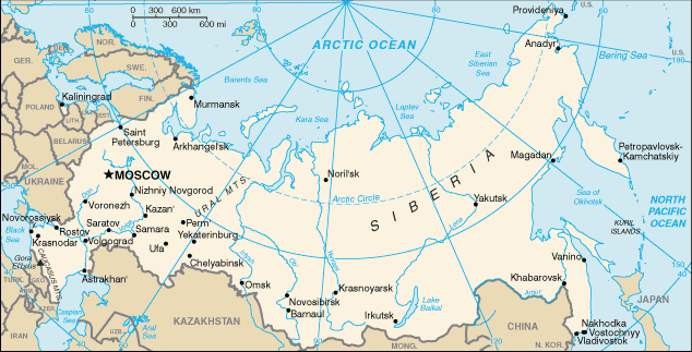
Αρχείο:Rs-map.png
Δεν διατίθεται υψηλότερη ανάλυση.
Rs-map.png (634 × 323 εικονοστοιχεία, μέγεθος αρχείου: 37 KB, τύπος MIME: image/png)
|
|
Αυτό το αρχείο και η περιγραφή του προέρχονται από το Wikimedia Commons. Οι πληροφορίες από την σελίδα περιγραφής του εκεί εμφανίζονται παρακάτω. |
CIA map of Russia. https://www.cia.gov/library/publications/the-world-factbook/geos/rs.html archive copy at the Wayback Machine
This version of CIA World Factbook map has few changes compared to the previous version at Commons.
See also SVG version: Image:Blank map of Russia-geoloc.svg
This image is in the public domain because it contains materials that originally came from the United States Central Intelligence Agency's World Factbook.
|
 |
.jpg)
| Annotations | This image is annotated: View the annotations at Commons |
Ιστορικό αρχείου
Κλικάρετε σε μια ημερομηνία/ώρα για να δείτε το αρχείο όπως εμφανιζόταν εκείνη τη στιγμή.
| Ώρα/Ημερομ. | Μικρογραφία | Διαστάσεις | Χρήστης | Σχόλια | |
|---|---|---|---|---|---|
| τελευταία | 16:40, 16 Μαΐου 2009 | | 634 × 323 (37 KB) | Pasixxxx | New version of this map from CIA World Factbook site. Few more cities, Yekaterinburg location has changed considerably compared to the Commons' previous version. From CIA World Factbook site [https://www.cia.gov/library/publications/the-world-factbook/geo |
| 15:50, 3 Δεκεμβρίου 2004 |  | 635 × 324 (29 KB) | Kneiphof | CIA map of Russia, PD |
Συνδέσεις αρχείου
Δεν υπάρχουν σελίδες που συνδέουν σε αυτό το αρχείο.
Καθολική χρήση αρχείου
Τα ακόλουθα άλλα wiki χρησιμοποιούν αυτό το αρχείο:
- Χρήση σε als.wikipedia.org
- Χρήση σε ar.wikipedia.org
- Χρήση σε ast.wikipedia.org
- Χρήση σε az.wiktionary.org
- Χρήση σε ceb.wikipedia.org
- Χρήση σε cs.wikipedia.org
- Χρήση σε de.wikipedia.org
- Χρήση σε diq.wikipedia.org
- Χρήση σε dsb.wikipedia.org
- Χρήση σε en.wikipedia.org
- Wikipedia:In the news/Candidates/December 2005
- List of twin towns and sister cities in Russia
- Wikipedia:Reference desk/Archives/Science/2007 July 18
- Northern river reversal
- Energy in Russia
- User:Epipelagic/sandbox/ref3
- Module talk:Location map/Archive 1
- User:Andrewjlockley/Hydraulic geoengineering2g
- User:Morriswa/My OCONUS travel
- User:Falcaorib
- Wikipedia:In the news/Posted/December 2005
- Χρήση σε en.wikibooks.org
- Χρήση σε en.wiktionary.org
- Χρήση σε es.wikipedia.org
- Χρήση σε fr.wikipedia.org
- Χρήση σε gl.wikipedia.org
- Χρήση σε he.wikipedia.org
- Χρήση σε hif.wikipedia.org
- Χρήση σε hu.wikipedia.org
Δείτε περισσότερη καθολική χρήση αυτού του αρχείου.