
Αρχείο:Mapka miedzymorza.png
Δεν διατίθεται υψηλότερη ανάλυση.
Mapka_miedzymorza.png (250 × 170 εικονοστοιχεία, μέγεθος αρχείου: 8 KB, τύπος MIME: image/png)
|
|
Αυτό το αρχείο και η περιγραφή του προέρχονται από το Wikimedia Commons. Οι πληροφορίες από την σελίδα περιγραφής του εκεί εμφανίζονται παρακάτω. |

|
This proposed entity map image could be re-created using vector graphics as an SVG file. This has several advantages; see Commons:Media for cleanup for more information. If an SVG form of this image is available, please upload it and afterwards replace this template with
{{vector version available|new image name}}.
It is recommended to name the SVG file “Mapka miedzymorza.svg”—then the template Vector version available (or Vva) does not need the new image name parameter. |
| Περιγραφή |
Беларуская (тарашкевіца): Мапа плянаванай канфэдэрацыі. Сьветлым колерам адзначаны тэрыторыі Беларусі і Ўкраіны, якія ўвайшлі ў Савецкую дзяржаву пасьля 1921.
Čeština: Mapu s vyznačením území, která by zahrnovala na Międzymorze federace. Světlejší zelená značí ukrajinské a běloruské území ovládané Sovětským svazem po roce 1921.
Deutsch: Karte zeigt die Gebiete, die die Międzymorze Föderation umfassen würde. Hellgrün bezeichnet ukrainischen und weißrussischen Gebiete von der Sowjetunion nach 1921 regiert.
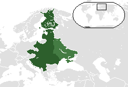
English: Map showing the territories that would comprise the Międzymorze federation. Lighter green denotes Ukrainian and Belarusian territories controlled by the Soviet Union after 1921.
Español: Mapa que muestra los territorios que componen la federación Międzymorze. De color verde claro indica territorios de Ucrania y Bielorrusia controladas por la Unión Soviética después de 1921.
Hrvatski: Karta pokazuje područja koja će obuhvaćaju Międzymorze federaciju. Upaljač zelena označava ukrajinski i bjeloruski područja kontrolom Sovjetskog Saveza nakon 1921.
Italiano: Cartina con i territori che compongono la federazione Międzymorze. Accendino verde denota territori ucraini e bielorussi controllati dall'Unione Sovietica dopo il 1921.
Lietuvių: Žemėlapis rodo teritorijas, kad būtų sukaupta Międzymorze federaciją. Žiebtuvėlis žalia žymi Ukrainos ir Baltarusijos teritorijas, kontroliuojamas Sovietų Sąjungos po 1921 m.
Polski: Mapa pokazująca terytoria, które składają się na Międzymorze federacji. Lżejszy zielony oznacza Ukrainy i Białorusi terytoria kontrolowane przez ZSRR po 1921 roku.
Русский: Карта с указанием территорий, которые должны были войти в Междуморье. Светло-зеленый показывает украинские и белорусские территории, которые попали под контроль Советского Союза после 1921 года.
Slovenčina: Mapu s vyznačením územia, ktorá by zahŕňala na Międzymorze federácie. Svetlejšie zelená značí ukrajinskej a bieloruskej územie ovládané Sovietskym zväzom po roku 1921.
Українська: Карта з позначеною територією, яка мала увійти до Міжмор’я. Світло-зелений колір показує українські та білоруські території, які потрапили під контроль Радянського Союзу після 1921 року. |
| Ημερομηνία | Uploaded to pl wiki on 6 April 2007. |
| Πηγή | Uploaded to pl wiki by creator. |
| Δημιουργός | Albertus |
| άλλες εκδόσεις |
 |
Εγώ, ο κάτοχος των πνευματικών δικαιωμάτων αυτού του έργου, το δημοσιεύω δια του παρόντος υπό τις εξής άδειες χρήσης:

|
Παραχωρείται η άδεια προς αντιγραφή, διανομή και/ή τροποποίηση αυτού του εγγράφου υπό τους όρους της Άδειας Ελεύθερης Τεκμηρίωσης GNU, Έκδοση 1.2 ή οποιασδήποτε νεότερης έκδοσης δημοσιευμένης από το Ίδρυμα Ελεύθερου Λογισμικού· χωρίς Απαράλαχτους Τομείς, χωρίς Κείμενα Εξωφύλλου, και χωρίς Κείμενα Οπισθοφύλλου. Αντίγραφο της άδειας περιλαμβάνεται στην σελίδα με τίτλο GNU Free Documentation License. |
Αυτό το αρχείο έχει αδειοδοτηθεί υπό τις Creative Commons Αναφορά προέλευσης 3.0 Unported, 2.5 Generic, 2.0 Generic και 1.0 Generic άδειες χρήσης.
- Είστε ελεύθερος:
- να μοιραστείτε – να αντιγράψετε, διανέμετε και να μεταδώσετε το έργο
- να διασκευάσετε – να τροποποιήσετε το έργο
- Υπό τις ακόλουθες προϋποθέσεις:
- αναφορά προέλευσης – Θα πρέπει να κάνετε κατάλληλη αναφορά, να παρέχετε σύνδεσμο για την άδεια και να επισημάνετε εάν έγιναν αλλαγές. Μπορείτε να το κάνετε με οποιοδήποτε αιτιολογήσιμο λόγο, χωρίς όμως να εννοείται με οποιονδήποτε τρόπο ότι εγκρίνουν εσάς ή τη χρήση του έργου από εσάς.
- παρόμοια διανομή – Εάν αλλάξετε, τροποποιήσετε ή δημιουργήσετε πάνω στο έργο αυτό, μπορείτε να διανείμετε αυτό που θα προκύψει μόνο υπό τους όρους της ίδιας ή συμβατής άδειας με το πρωτότυπο.
Μπορείτε να επιλέξετε την άδεια της προτίμησής σας.
| Annotations | This image is annotated: View the annotations at Commons |
Ιστορικό αρχείου
Κλικάρετε σε μια ημερομηνία/ώρα για να δείτε το αρχείο όπως εμφανιζόταν εκείνη τη στιγμή.
| Ώρα/Ημερομ. | Μικρογραφία | Διαστάσεις | Χρήστης | Σχόλια | |
|---|---|---|---|---|---|
| τελευταία | 04:20, 12 Μαΐου 2014 | | 250 × 170 (8 KB) | Spesh531 | italian coastline fixed and island in turkey removed |
| 04:06, 12 Μαΐου 2014 |  | 250 × 170 (8 KB) | Spesh531 | fixing east prussia and lithuania borders | |
| 03:59, 12 Μαΐου 2014 |  | 250 × 170 (8 KB) | Spesh531 | further south map | |
| 03:42, 12 Μαΐου 2014 |  | 250 × 150 (7 KB) | Spesh531 | update | |
| 04:14, 17 Ιουλίου 2012 |  | 250 × 150 (5 KB) | Spesh531 | Version with all proposed countries, so +Finland, updated layout | |
| 19:15, 22 Απριλίου 2007 |  | 250 × 115 (9 KB) | Piotrus | {{Information |Description=Map showing the territories that would comprise the Międzymorze federation. Lighter green denotes Ukrainian and Belarusian territories controlled by the Soviet Union after 1921. |Source=Uploaded to pl wiki by creator. |Date=Upl |
Συνδέσεις αρχείου
Τα παρακάτω λήμματα συνδέουν σε αυτό το αρχείο:
Καθολική χρήση αρχείου
Τα ακόλουθα άλλα wiki χρησιμοποιούν αυτό το αρχείο:
- Χρήση σε be-tarask.wikipedia.org
- Χρήση σε be.wikipedia.org
- Χρήση σε ca.wikipedia.org
- Χρήση σε de.wikipedia.org
- Χρήση σε en.wikipedia.org
- Χρήση σε eo.wikipedia.org
- Χρήση σε es.wikipedia.org
- Χρήση σε et.wikipedia.org
- Χρήση σε hr.wikipedia.org
- Χρήση σε hy.wikipedia.org
- Χρήση σε id.wikipedia.org
- Χρήση σε ja.wikipedia.org
- Χρήση σε ka.wikipedia.org
- Χρήση σε lv.wikipedia.org
- Χρήση σε no.wikipedia.org
- Χρήση σε pl.wikipedia.org
- Χρήση σε ro.wikipedia.org
- Χρήση σε ru.wikipedia.org
- Χρήση σε sh.wikipedia.org
- Χρήση σε sk.wikipedia.org
- Χρήση σε sr.wikipedia.org
- Χρήση σε sv.wikipedia.org
- Χρήση σε tr.wikipedia.org
- Χρήση σε uk.wikipedia.org
- Χρήση σε vi.wikipedia.org
- Χρήση σε zh.wikipedia.org