
Αρχείο:Danubemap.png
Δεν διατίθεται υψηλότερη ανάλυση.
Danubemap.png (747 × 480 εικονοστοιχεία, μέγεθος αρχείου: 601 KB, τύπος MIME: image/png)
|
|
Αυτό το αρχείο και η περιγραφή του προέρχονται από το Wikimedia Commons. Οι πληροφορίες από την σελίδα περιγραφής του εκεί εμφανίζονται παρακάτω. |

|
This map image could be re-created using vector graphics as an SVG file. This has several advantages; see Commons:Media for cleanup for more information. If an SVG form of this image is available, please upload it and afterwards replace this template with
{{vector version available|new image name}}.
It is recommended to name the SVG file “Danubemap.svg”—then the template Vector version available (or Vva) does not need the new image name parameter. |
Σύνοψη
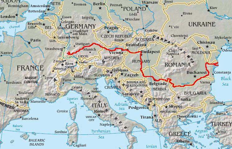
English: Map showing the flow of the Danube River. Uses the map of Europe from the CIA World Factbook.
Αδειοδότηση
This image is in the public domain because it contains materials that originally came from the United States Central Intelligence Agency's World Factbook.
|
 |
Ιστορικό αρχείου
Κλικάρετε σε μια ημερομηνία/ώρα για να δείτε το αρχείο όπως εμφανιζόταν εκείνη τη στιγμή.
| Ώρα/Ημερομ. | Μικρογραφία | Διαστάσεις | Χρήστης | Σχόλια | |
|---|---|---|---|---|---|
| τελευταία | 05:34, 12 Φεβρουαρίου 2007 | | 747 × 480 (601 KB) | Geologik | Map showing the flow of the Danube River. Uses the map of Europe from the CIA World Factbook. |
Συνδέσεις αρχείου
Τα παρακάτω λήμματα συνδέουν σε αυτό το αρχείο:
- Άλτμυλ
- Άντα Καλέ
- Ίλλερ
- Ίνγκολστατ
- Βελιγράδι
- Βιέννη
- Βουδαπέστη
- Βραΐλα
- Γκαλάτσι
- Γκιούρ
- Δούναβης
- Δράβος
- Εννς (ποταμός)
- Ζίτνι Όστροβ
- Ιαλομίτσα (ποταμός)
- Ινν (ποταμός)
- Λεχ
- Λιντς (Αυστρία)
- Μάχη της Νικόπολης (1396)
- Μεγάλο νησί της Βραΐλας
- Μεγάλο νησί του πολέμου
- Μεγάλος Μοράβας
- Μικρό νησί του πολέμου
- Μοράβας
- Μπρατισλάβα
- Νήσος Κοζλοντούι
- Νήσος Μπελένε
- Νήσος Σάρενγκραντ
- Νησί της Μαργαρίτας
- Νησί του Βούκοβαρ
- Ντόναουινζελ
- Νόβι Σαντ
- Ουλμ
- Πάσσαου
- Προύθος
- Ρέγκενσμπουργκ
- Ρούσε
- Σάβος
- Σερέτης (ποταμός)
- Τίμις
- Τίσα
- Τούλτσεα
- Πρότυπο:Δούναβης
Καθολική χρήση αρχείου
Τα ακόλουθα άλλα wiki χρησιμοποιούν αυτό το αρχείο:
- Χρήση σε ang.wikipedia.org
- Χρήση σε ast.wikipedia.org
- Χρήση σε av.wikipedia.org
- Χρήση σε azb.wikipedia.org
- Χρήση σε ban.wikipedia.org
- Χρήση σε be-tarask.wikipedia.org
- Χρήση σε bg.wikipedia.org
Δείτε περισσότερη καθολική χρήση αυτού του αρχείου.