
Αρχείο:Xinjiang Internment Map, US-Aus Gov Assessment.jpg
Μέγεθος αυτής της προεπισκόπησης: 800 × 495 εικονοστοιχεία . Άλλες αναλύσεις: 320 × 198 εικονοστοιχεία | 640 × 396 εικονοστοιχεία | 1.024 × 634 εικονοστοιχεία | 1.280 × 792 εικονοστοιχεία | 2.048 × 1.267 εικονοστοιχεία.
Εικόνα σε υψηλότερη ανάλυση (2.048 × 1.267 εικονοστοιχεία, μέγεθος αρχείου: 150 KB, τύπος MIME: image/jpeg)
|
|
Αυτό το αρχείο και η περιγραφή του προέρχονται από το Wikimedia Commons. Οι πληροφορίες από την σελίδα περιγραφής του εκεί εμφανίζονται παρακάτω. |
Σύνοψη
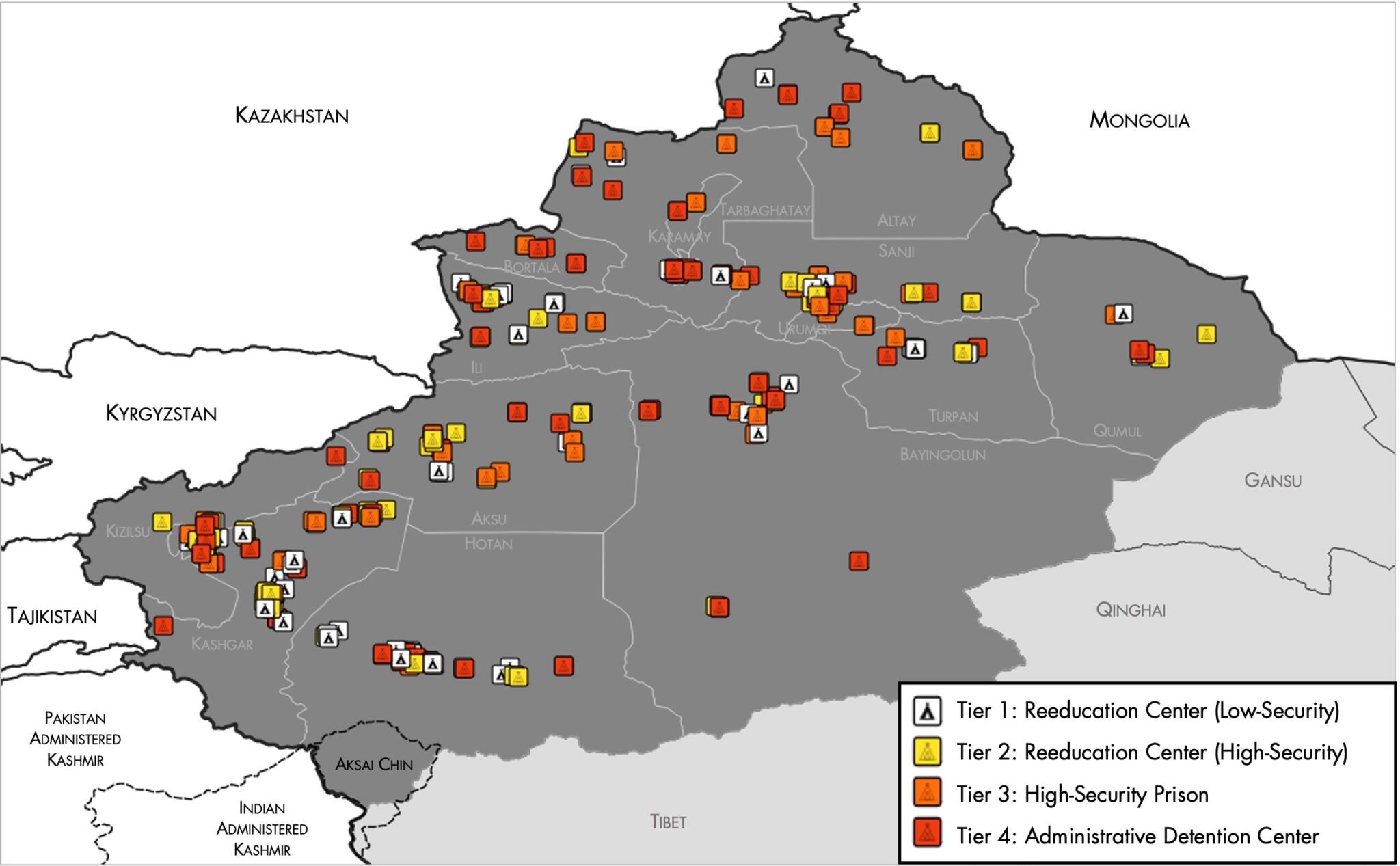
| Περιγραφή |
English: Map of the Xinjiang Internment Camps created by the RAND Corporation based on data collected by the US National Geospatial Intelligence Agency and the Australian Strategic Policy Institute. Open source here. |
||||||||
| Ημερομηνία | |||||||||
| Πηγή | https://www.tearline.mil/public_page/xinjiang-nighttime-1/ | ||||||||
| Δημιουργός | National Geospatial Intelligence Agency, using data from the Australian Strategic Policy Institute, and administrative boundaries from GADM. | ||||||||
| Άδεια (Επαναχρησιμοποίηση αυτού του αρχείου) |
|


Ιστορικό αρχείου
Κλικάρετε σε μια ημερομηνία/ώρα για να δείτε το αρχείο όπως εμφανιζόταν εκείνη τη στιγμή.
| Ώρα/Ημερομ. | Μικρογραφία | Διαστάσεις | Χρήστης | Σχόλια | |
|---|---|---|---|---|---|
| τελευταία | 05:05, 2 Μαΐου 2021 | | 2.048 × 1.267 (150 KB) | Abovfold | Uploaded a work by {{w|National Geospatial Intelligence Agency}}, using data from the {{w|Australian Strategic Policy Institute}}, and administrative boundaries from {{w|GADM}}. from https://www.tearline.mil/public_page/xinjiang-nighttime-1/ with UploadWizard |
Συνδέσεις αρχείου
Τα παρακάτω λήμματα συνδέουν σε αυτό το αρχείο:
Καθολική χρήση αρχείου
Τα ακόλουθα άλλα wiki χρησιμοποιούν αυτό το αρχείο:
- Χρήση σε ba.wikipedia.org
- Χρήση σε br.wikipedia.org
- Χρήση σε cs.wikipedia.org
- Χρήση σε de.wikipedia.org
- Χρήση σε en.wikipedia.org
- Χρήση σε es.wikipedia.org
- Χρήση σε fi.wikipedia.org
- Χρήση σε fr.wikipedia.org
- Χρήση σε ga.wikipedia.org
- Χρήση σε he.wikipedia.org
- Χρήση σε km.wikipedia.org
- Χρήση σε nl.wikipedia.org
- Χρήση σε or.wikipedia.org
- Χρήση σε pl.wikipedia.org
- Χρήση σε pt.wikipedia.org
- Χρήση σε ru.wikinews.org
- Χρήση σε sv.wikipedia.org
- Χρήση σε szl.wikipedia.org
- Χρήση σε tr.wikipedia.org
- Χρήση σε www.wikidata.org