
Αρχείο:US pennsylvanian general USGS.jpg

Δεν διατίθεται υψηλότερη ανάλυση.
US_pennsylvanian_general_USGS.jpg (500 × 353 εικονοστοιχεία, μέγεθος αρχείου: 22 KB, τύπος MIME: image/jpeg)
|
|
Αυτό το αρχείο και η περιγραφή του προέρχονται από το Wikimedia Commons. Οι πληροφορίες από την σελίδα περιγραφής του εκεί εμφανίζονται παρακάτω. |

|
This map image could be re-created using vector graphics as an SVG file. This has several advantages; see Commons:Media for cleanup for more information. If an SVG form of this image is available, please upload it and afterwards replace this template with
{{vector version available|new image name}}.
It is recommended to name the SVG file “US pennsylvanian general USGS.svg”—then the template Vector version available (or Vva) does not need the new image name parameter. |


Σύνοψη
| Περιγραφή |
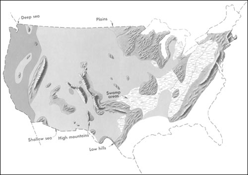
English: Generalized geographic map of the United States location in Middle Pennsylvanian time.
During the Carboniferous period, the contrast in the distribution of land and water from the ancient past to the present becomes more dramatic. The map shows the outline of the United States as it looked during the Pennsylvanian Period some 300 million years ago. It gives the appearance of reversing present-day geography. A highland which lay to the east, south, and north supplied much of the sedimentary debris that was spread over the midwestern part of the United States. The Midwest was mainly a low swampy area in which scouring rushes and fern trees grew in profusion. Sediment was carried into the region from deltas to the east. From time to time, the level of the sea fluctuated -- possibly because of glacial conditions in the Southern Hemisphere. Swamps were flooded, and forests were destroyed. Slowly, layers rich in tree stumps, spores, branches, and leaves were deposited. Later, heat and pressure changed these layers into the coal beds that are so extensive in Illinois, Kentucky, Pennsylvania, West Virginia, and Tennessee. To the west, marine limestones, sandstones, and shales accumulated in shallow seas whose vast expanses were dotted with shoals and islands. Some of the very large islands were formed by the buckling and uplifting of parts of the Earth's crust. |
| Ημερομηνία | έως 2001 |
| Πηγή | http://pubs.usgs.gov/gip/continents/pennmap.jpg |
| Δημιουργός |
Αδειοδότηση
This image is in the public domain in the United States because it only contains materials that originally came from the United States Geological Survey, an agency of the United States Department of the Interior. For more information, see the official USGS copyright policy.
|
Καταγραφές ανεβασμάτων πρωτότυπου αρχείου
The original description page was here. All following user names refer to en.wikipedia.
| Ημερομηνία/Ώρα | Διαστάσεις | Χρήστης | Σχόλιο |
|---|---|---|---|
| 2005-04-15 02:48 | 500×353× (22509 bytes) | SEWilco | Generalized geographic map of the [[United States]] in [[Middle Pennsylvanian]] time. In the Coal Age, the contrast in the distribution of land and water from the ancient past to the present becomes more dramatic. The map shows the outline of the United |
The original description page was here. All following user names refer to el.wikipedia.
| Ημερομηνία/Ώρα | Διαστάσεις | Χρήστης | Σχόλιο |
|---|---|---|---|
| 2016-01-16 16:00 | 500×353× (22509 bytes) | Kalogeropoulos | {{Πληροφορίες εικόνας |Περιγραφή=Γενικός γεωγραφικός χάρτης των [[ΗΠΑ]] κατά τη μέση [[Πενσυλβάνια εποχή]] |Πηγή=http://pubs.usgs.gov/gip/continents/pennmap.jpg |Η... |
Ιστορικό αρχείου
Κλικάρετε σε μια ημερομηνία/ώρα για να δείτε το αρχείο όπως εμφανιζόταν εκείνη τη στιγμή.
| Ώρα/Ημερομ. | Μικρογραφία | Διαστάσεις | Χρήστης | Σχόλια | |
|---|---|---|---|---|---|
| τελευταία | 07:04, 22 Οκτωβρίου 2016 | | 500 × 353 (22 KB) | MARKELLOS | Transferred from el.wikipedia |
Συνδέσεις αρχείου
Τα παρακάτω λήμματα συνδέουν σε αυτό το αρχείο:
Καθολική χρήση αρχείου
Τα ακόλουθα άλλα wiki χρησιμοποιούν αυτό το αρχείο:
- Χρήση σε en.wikipedia.org
- Χρήση σε fa.wikipedia.org
- Χρήση σε zh.wikipedia.org