
Αρχείο:Shiveluch - 10 July 2007 - iss015e16913.jpg
Μέγεθος αυτής της προεπισκόπησης: 800 × 531 εικονοστοιχεία . Άλλες αναλύσεις: 320 × 212 εικονοστοιχεία | 640 × 425 εικονοστοιχεία | 1.024 × 680 εικονοστοιχεία | 1.280 × 849 εικονοστοιχεία | 3.032 × 2.012 εικονοστοιχεία.
Εικόνα σε υψηλότερη ανάλυση (3.032 × 2.012 εικονοστοιχεία, μέγεθος αρχείου: 1,06 MB, τύπος MIME: image/jpeg)
|
|
Αυτό το αρχείο και η περιγραφή του προέρχονται από το Wikimedia Commons. Οι πληροφορίες από την σελίδα περιγραφής του εκεί εμφανίζονται παρακάτω. |
| Περιγραφή |
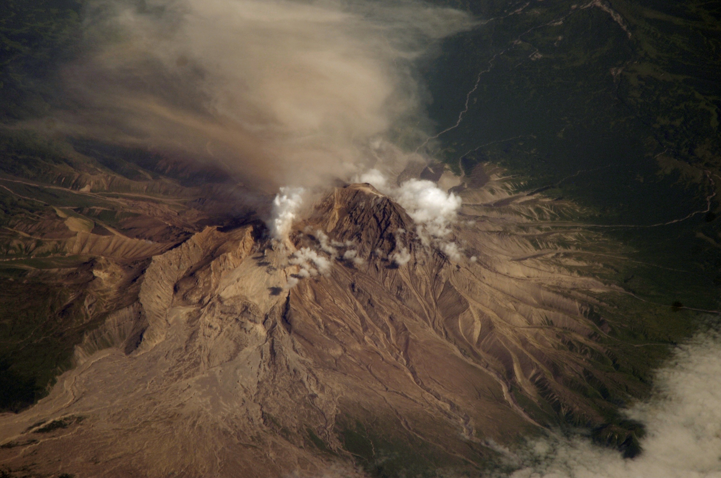
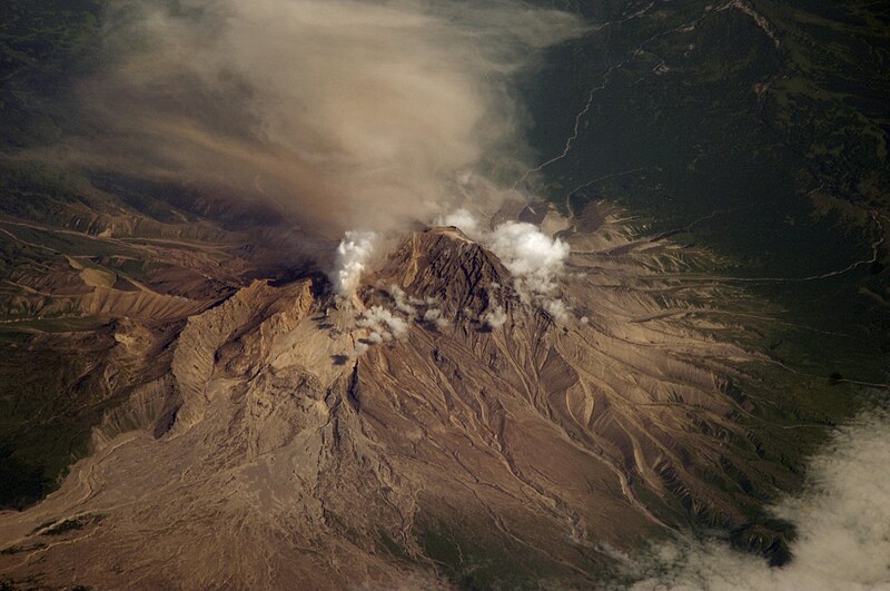
English: Photo of the Shiveluch volcano from the International Space Station. Description from that site: ISS015-E-16913 (10 July 2007) --- Shiveluch Volcano, Kamchatka, Russian Far East is featured in this image photographed by an Expedition 15 crewmember on the International Space Station. Shiveluch is one of the biggest and most active of a line of volcanoes along the spine of the Kamchatka peninsula in easternmost Russia. In turn the volcanoes and peninsula are part of the tectonically active "Ring of Fire" that almost surrounds the Pacific Ocean, denoted by active volcanoes and frequent earthquakes. Shiveluch occupies the point where the northeast-trending Kamchatka volcanic line intersects the northwest-trending Aleutian volcanic line. Junctions such as this are typically points of intense volcanic activity. According to scientists, the summit rocks of Shiveluch have been dated at approximately 65,000 years old. Lava layers on the sides of the volcano reveal at least 60 major eruptions in the last 10,000 years, making it the most active volcano in the 2,200 kilometer distance that includes the Kamchatka peninsula and the Kuril island chain. Shiveluch rises from almost sea level to well above 3,200 metres (summit altitude 3,283 metres) and is often capped with snow. In this summer image however, the full volcano is visible, actively erupting ash and steam in late June or early July, 2007. The dull brown plume extending from the north of the volcano summit is most likely a combination of ash and steam (top). The two larger white plumes near the summit are dominantly steam, a common adjunct to eruptions, as rain and melted snow percolate down to the hot interior of the volcano. The sides of the volcano show many eroded stream channels. The south slope also reveals a long sloping apron of collapsed material, or pyroclastic flows. Such debris flows have repeatedly slid down and covered the south side of the volcano during major eruptions when the summit lava domes explode and collapse (this occurred during major eruptions in 1854 and 1964). Regrowth of the forest on the south slope (note the contrast with the eastern slope) has been foiled by the combined effects of continued volcanic activity, instability of the debris flows and the short growing season. |
| Ημερομηνία | |
| Πηγή | JSC Gateway to Astronaut Photography of Earth |
| Δημιουργός | Earth Science and Remote Sensing Unit, Διαστημικό Κέντρο Τζόνσον |
| Mission | ISS015 |
| Roll | E |
| Frame | 16913 |
| Geographic area | Russia |
| Features | SHIVELUCH VOLCANO, PLUMES |
| Cloud percentage | 10% |
| Altitude | 174 nautical miles (322 km) |
| Look angle | HO |
| Look direction | N |
| Sun Azimuth | 112° |
| Sun Elevation | 44° |
| Camera | Nikon D1 Electronic Still Camera |
| Focal length | 800 mm |
| Object location | | View this and other nearby images on: OpenStreetMap |
|---|
| Camera location | | View this and other nearby images on: OpenStreetMap |
|---|
This image or video was catalogued by Johnson Space Center of the United States National Aeronautics and Space Administration (NASA) under Photo ID: ISS015-E-16913. This tag does not indicate the copyright status of the attached work. A normal copyright tag is still required. See Commons:Licensing. Other languages:
|
| Αυτό το αρχείο είναι κοινό κτήμα γιατί δημιουργήθηκε από την NASA. Η πολιτική πνευματικής ιδιοκτησίας της NASA δηλώνει ότι «Το υλικό της NASA δεν προστατεύεται από copyright εκτός αν αναφέρεται». (Σελίδα με την πολιτική πνευματικής ιδιοκτησίας της NASA ή Πολιτική Χρήσης Εικόνων του JPL). | ||
 |
Προσοχή:
|
Ιστορικό αρχείου
Κλικάρετε σε μια ημερομηνία/ώρα για να δείτε το αρχείο όπως εμφανιζόταν εκείνη τη στιγμή.
| Ώρα/Ημερομ. | Μικρογραφία | Διαστάσεις | Χρήστης | Σχόλια | |
|---|---|---|---|---|---|
| τελευταία | 19:44, 17 Οκτωβρίου 2023 | | 3.032 × 2.012 (1,06 MB) | Don-vip | Cropped < 1 % vertically using CropTool with lossless mode. |
| 11:09, 1 Μαρτίου 2011 |  | 3.032 × 2.013 (1,06 MB) | Originalwana | cropped | |
| 02:11, 17 Σεπτεμβρίου 2007 |  | 3.032 × 2.068 (1,07 MB) | Avenue | Photo of the Shiveluch volcano from the International Space Station. Source: [http://spaceflight.nasa.gov/gallery/images/station/crew-15/html/iss015e16913.html] Description from that site: ISS015-E-16913 (10 July 2007) --- Shiveluch Vol |
Συνδέσεις αρχείου
Δεν υπάρχουν σελίδες που συνδέουν σε αυτό το αρχείο.
Καθολική χρήση αρχείου
Τα ακόλουθα άλλα wiki χρησιμοποιούν αυτό το αρχείο:
- Χρήση σε ceb.wikipedia.org
- Χρήση σε cs.wikipedia.org
- Χρήση σε cv.wikipedia.org
- Χρήση σε de.wikipedia.org
- Χρήση σε en.wikipedia.org
- Χρήση σε es.wikipedia.org
- Χρήση σε et.wikipedia.org
- Χρήση σε fi.wikipedia.org
- Χρήση σε fr.wikipedia.org
- Χρήση σε it.wikipedia.org
- Χρήση σε ja.wikipedia.org
- Χρήση σε lt.wikipedia.org
- Χρήση σε nl.wikipedia.org
- Χρήση σε nn.wikipedia.org
- Χρήση σε pl.wikipedia.org
- Χρήση σε pt.wikipedia.org
- Χρήση σε ru.wikipedia.org
- Χρήση σε ru.wikinews.org
- Χρήση σε uk.wikipedia.org
- Χρήση σε zh.wikipedia.org