
Αρχείο:PonticKingdom.png

Μέγεθος αυτής της προεπισκόπησης: 718 × 600 εικονοστοιχεία . Άλλες αναλύσεις: 287 × 240 εικονοστοιχεία | 575 × 480 εικονοστοιχεία | 919 × 768 εικονοστοιχεία | 1.226 × 1.024 εικονοστοιχεία | 1.551 × 1.296 εικονοστοιχεία.
Εικόνα σε υψηλότερη ανάλυση (1.551 × 1.296 εικονοστοιχεία, μέγεθος αρχείου: 265 KB, τύπος MIME: image/png)
|
|
Αυτό το αρχείο και η περιγραφή του προέρχονται από το Wikimedia Commons. Οι πληροφορίες από την σελίδα περιγραφής του εκεί εμφανίζονται παρακάτω. |

|
This historical map image could be re-created using vector graphics as an SVG file. This has several advantages; see Commons:Media for cleanup for more information. If an SVG form of this image is available, please upload it and afterwards replace this template with
{{vector version available|new image name}}.
It is recommended to name the SVG file “PonticKingdom.svg”—then the template Vector version available (or Vva) does not need the new image name parameter. |
| Περιγραφή |
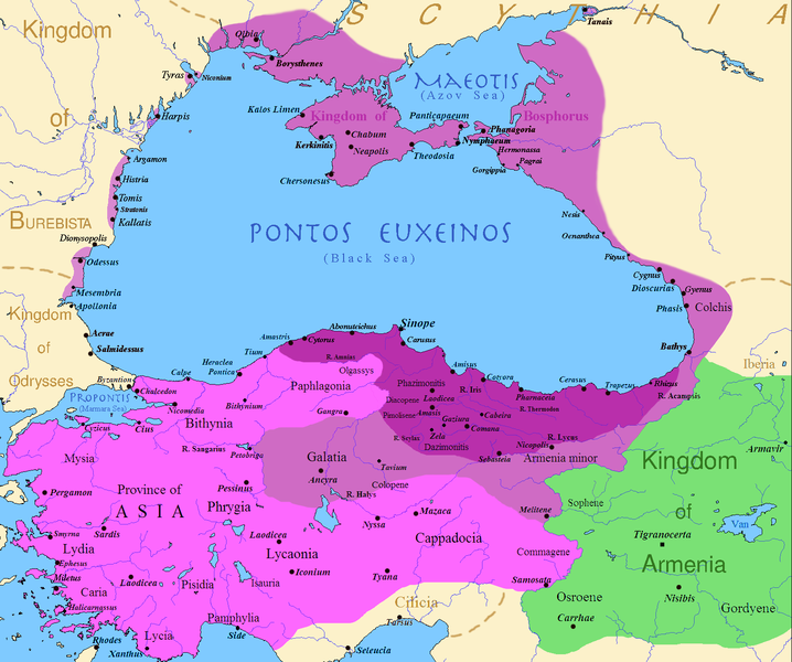
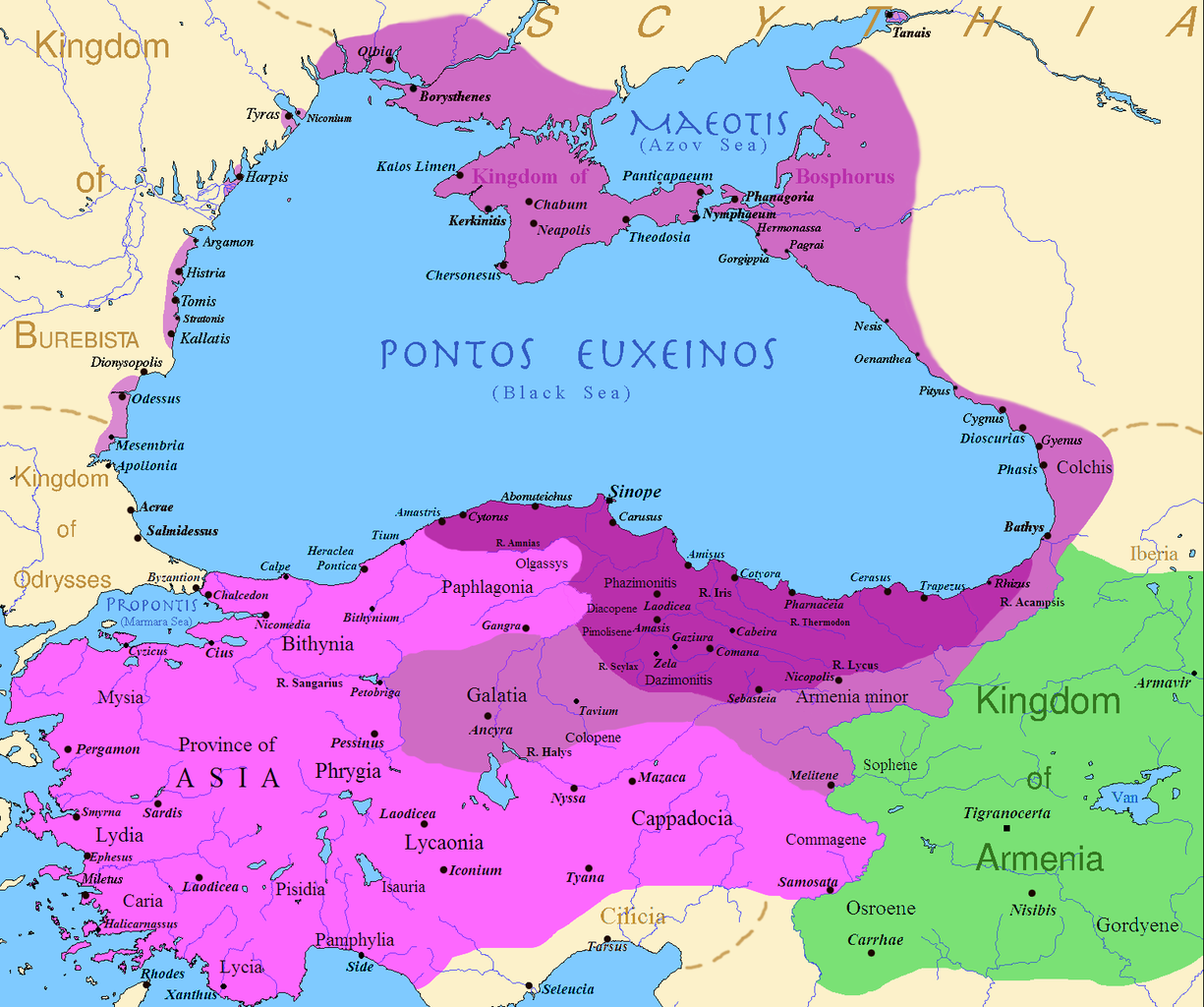
English: Map of the Kingdom of Pontus, Before the reign of Mithridates VI (darkest purple), after his conquests (purple), and his conquests in the first Mithridatic wars (pink); little adds (ancient shorelines & some greek colonies under Mithridate's rule) according with V. Yanko-Hombach, A.S. Gilbert, N. Panin, P. M. Dolukhanov: The Black Sea Flood Question: Changes in Coastline, Climate, and Human Settlement, Springer, Netherlands, 2007, and with Appianus, Plutarchus & Strabo. |
| Ημερομηνία | |
| Πηγή | I (Javierfv1212 (talk)) created this work entirely by myself. Sources, Cambridge Ancient history volume 9, Penguin atlas of Greek history and the Foreign Policy of Mithridates VI Eupator. |
| Δημιουργός | Javierfv1212 (talk) |
Αδειοδότηση
| Το έργο αυτό έχει απελευθερωθεί στην public domain από τον δημιουργό του, Javierfv1212 at Αγγλικά Βικιπαίδεια. Αυτό ισχύει σε όλο τον κόσμο. Σε ορισμένες χώρες αυτό μπορεί να μην είναι νομικά εφικτό. Αν ναι: Javierfv1212 Παραχωρώ σε οποιονδήποτε το δικαίωμα να χρησιμοποιήσει αυτό το έργο "για οποιονδήποτε σκοπό", χωρίς κανέναν όρο, εκτός και αν τέτοιοι όροι τίθενται από την νομοθεσία |
Καταγραφές ανεβασμάτων πρωτότυπου αρχείου
Transferred from en.wikipedia to Commons by Falcorian using CommonsHelper.
The original description page was here. All following user names refer to en.wikipedia.
- 2009-07-19 23:42 Javierfv1212 1551×1296× (205182 bytes) {{Information |Description = Map of the Kingdom of Pontus, Before the reign of mithridates VI (darkest purple), after his conquests (purple), and his conquests in the first Mithridatic wars (pink). |Source = I (~~~) created this work entirel
Ιστορικό αρχείου
Κλικάρετε σε μια ημερομηνία/ώρα για να δείτε το αρχείο όπως εμφανιζόταν εκείνη τη στιγμή.
| Ώρα/Ημερομ. | Μικρογραφία | Διαστάσεις | Χρήστης | Σχόλια | |
|---|---|---|---|---|---|
| τελευταία | 02:00, 9 Δεκεμβρίου 2017 | | 1.551 × 1.296 (265 KB) | SteinsplitterBot | Bot: Image rotated by 90° |
| 00:00, 9 Δεκεμβρίου 2017 |  | 1.296 × 1.551 (316 KB) | SteinsplitterBot | Bot: Image rotated by 270° | |
| 17:54, 22 Σεπτεμβρίου 2016 |  | 1.551 × 1.296 (265 KB) | Hohum | Lighten water area | |
| 11:21, 9 Αυγούστου 2016 |  | 1.551 × 1.296 (260 KB) | MAXHO | Details : more cities & shoreline of this time | |
| 20:57, 1 Οκτωβρίου 2015 |  | 1.551 × 1.296 (249 KB) | Spiridon Ion Cepleanu | Cosmetic again | |
| 12:55, 30 Σεπτεμβρίου 2015 |  | 1.551 × 1.296 (247 KB) | Spiridon Ion Cepleanu | Cosmetic colours & background names | |
| 14:21, 7 Απριλίου 2014 |  | 1.551 × 1.296 (225 KB) | Spiridon Ion Cepleanu | Little changes (ancient shoreline & some greek colonies under Pontic rule) according with V. Yanko-Hombach, A.S. Gilbert, N. Panin, P. M. Dolukhanov: ''The Black Sea Flood Question: Changes in Coastline, Climate, and Human Settlement'', Springer, Nethe... | |
| 04:14, 20 Ιουλίου 2009 |  | 1.551 × 1.296 (200 KB) | File Upload Bot (Magnus Manske) | {{BotMoveToCommons|en.wikipedia|year={{subst:CURRENTYEAR}}|month={{subst:CURRENTMONTHNAME}}|day={{subst:CURRENTDAY}}}} {{Information |Description={{en|Map of the Kingdom of Pontus, Before the reign of mithridates VI (darkest purple), after his conquests |
Συνδέσεις αρχείου
Τα παρακάτω λήμματα συνδέουν σε αυτό το αρχείο:
Καθολική χρήση αρχείου
Τα ακόλουθα άλλα wiki χρησιμοποιούν αυτό το αρχείο:
- Χρήση σε ar.wikipedia.org
- Χρήση σε ast.wikipedia.org
- Χρήση σε azb.wikipedia.org
- Χρήση σε az.wikipedia.org
- Χρήση σε bg.wikipedia.org
- Χρήση σε br.wikipedia.org
- Χρήση σε ca.wikipedia.org
- Χρήση σε cs.wikipedia.org
- Χρήση σε da.wikipedia.org
- Χρήση σε de.wikipedia.org
- Χρήση σε en.wikipedia.org
- Χρήση σε es.wikipedia.org
- Χρήση σε et.wikipedia.org
- Χρήση σε eu.wikipedia.org
- Χρήση σε fa.wikipedia.org
- Χρήση σε fr.wikipedia.org
- Χρήση σε gl.wikipedia.org
Δείτε περισσότερη καθολική χρήση αυτού του αρχείου.