
Αρχείο:Peloponnesian war alliances 431 BC.png
Μέγεθος αυτής της προεπισκόπησης: 387 × 600 εικονοστοιχεία . Άλλες αναλύσεις: 155 × 240 εικονοστοιχεία | 482 × 747 εικονοστοιχεία.
Εικόνα σε υψηλότερη ανάλυση (482 × 747 εικονοστοιχεία, μέγεθος αρχείου: 37 KB, τύπος MIME: image/png)
|
|
Αυτό το αρχείο και η περιγραφή του προέρχονται από το Wikimedia Commons. Οι πληροφορίες από την σελίδα περιγραφής του εκεί εμφανίζονται παρακάτω. |
Σύνοψη

|
Μια διανυσματική έκδοση αυτής της εικόνας (SVG) είναι διαθέσιμη. Θα πρέπει να χρησιμοποιείται στην θέση αυτής της ράστερ εικόνας όταν είναι καλύτερη.
File:Peloponnesian war alliances 431 BC.png → File:Guerre del Peloponneso 431aC mappa.svg
Για περισσότερες πληροφορίες σχετικά με τα διανυσματικά γραφικά, διαβάστε για την κίνηση των Commons προς τα SVG. Υπάρχουν επίσης πληροφορίες για την υποστήριξη εικόνων SVG από το MediaWiki. |
 |
| Περιγραφή |
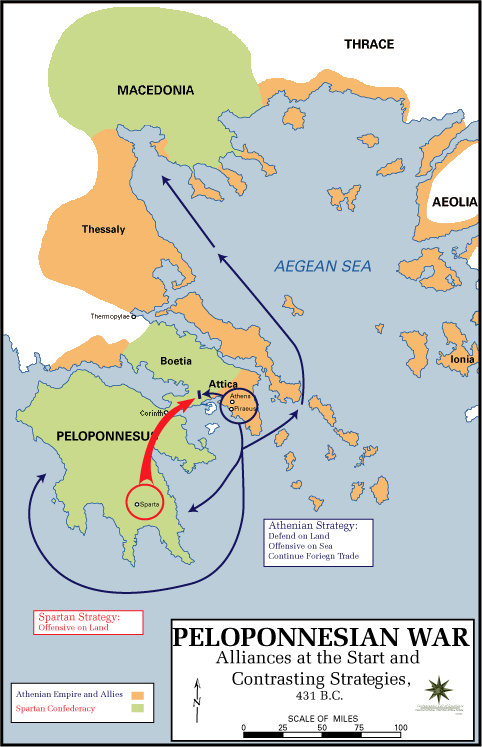
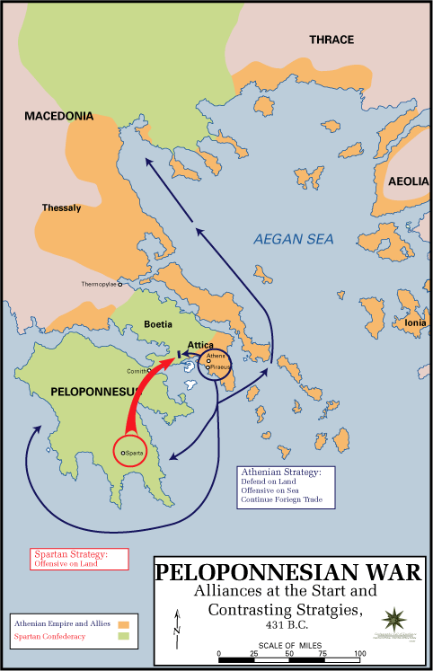
English: The Alliances of the Peloponnesian War |
| Ημερομηνία | 5 Μαΐου 2009 (original upload date) |
| Πηγή |
|
| Δημιουργός | U.S. Army Cartographer, as amended by uploader to correct spelling mistake |
| Άδεια (Επαναχρησιμοποίηση αυτού του αρχείου) |
Public domain as a work of the U.S. military.; amendments also released into the public domain |
| άλλες εκδόσεις |
|
Αδειοδότηση
This work is in the public domain in the United States because it is a work prepared by an officer or employee of the United States Government as part of that person’s official duties under the terms of Title 17, Chapter 1, Section 105 of the US Code.
Note: This only applies to original works of the Federal Government and not to the work of any individual U.S. state, territory, commonwealth, county, municipality, or any other subdivision. This template also does not apply to postage stamp designs published by the United States Postal Service since 1978. (See § 313.6(C)(1) of Compendium of U.S. Copyright Office Practices). It also does not apply to certain US coins; see The US Mint Terms of Use.
|
 | |
| Αυτό το αρχείο έχει χαρακτηριστεί ως απαλλαγμένο από γνωστούς περιορισμούς βάσει της νομοθεσίας περί πνευματικής ιδιοκτησίας, περιλαμβανομένων όλων των συναφών και συγγενικών δικαιωμάτων. | ||
Καταγραφές ανεβασμάτων πρωτότυπου αρχείου
The original description page was here. All following user names refer to en.wikipedia.
- 2009-05-05 11:43 The Anome 482×747× (34269 bytes) Fixed second spelling mistake, which had been accidentally reinstated by reverting to original source.
- 2009-05-05 11:28 The Anome 482×747× (34263 bytes) {{Information |Description = The Alliances of the Peloponnesian War |Source = http://www.faculty.umb.edu/gary_zabel/Courses/Phil%20281b/Maps/peloponnesian_war_alliances.gif |Date = |Author = U.S. Army Cartographer, as ame
Ιστορικό αρχείου
Κλικάρετε σε μια ημερομηνία/ώρα για να δείτε το αρχείο όπως εμφανιζόταν εκείνη τη στιγμή.
| Ώρα/Ημερομ. | Μικρογραφία | Διαστάσεις | Χρήστης | Σχόλια | |
|---|---|---|---|---|---|
| τελευταία | 19:35, 30 Μαρτίου 2018 | | 482 × 747 (37 KB) | Trecătorul răcit | Gulf of Pella in the time, position of names |
| 12:03, 5 Μαΐου 2009 |  | 482 × 747 (33 KB) | File Upload Bot (Magnus Manske) | {{BotMoveToCommons|en.wikipedia|year={{subst:CURRENTYEAR}}|month={{subst:CURRENTMONTHNAME}}|day={{subst:CURRENTDAY}}}} {{Information |Description={{en|The Alliances of the Peloponnesian War}} |Source=Transferred from [http://en.wikipedia.org en.wikipedia |
Συνδέσεις αρχείου
Τα παρακάτω λήμματα συνδέουν σε αυτό το αρχείο:
Καθολική χρήση αρχείου
Τα ακόλουθα άλλα wiki χρησιμοποιούν αυτό το αρχείο:
- Χρήση σε ar.wikipedia.org
- Χρήση σε br.wikipedia.org
- Χρήση σε ca.wikipedia.org
- Χρήση σε da.wikipedia.org
- Χρήση σε en.wikipedia.org
- Χρήση σε et.wikipedia.org
- Χρήση σε eu.wikipedia.org
- Χρήση σε fa.wikipedia.org
- Χρήση σε fi.wikipedia.org
- Χρήση σε fr.wikipedia.org
- Χρήση σε hyw.wikipedia.org
- Χρήση σε id.wikibooks.org
- Χρήση σε it.wikipedia.org
- Χρήση σε ka.wikipedia.org
- Χρήση σε ko.wikipedia.org
- Χρήση σε lv.wikipedia.org
- Χρήση σε ml.wikipedia.org
- Χρήση σε ro.wikipedia.org
- Χρήση σε ru.wikipedia.org
- Χρήση σε sh.wikipedia.org
- Χρήση σε sk.wikipedia.org
- Χρήση σε sq.wikipedia.org
- Χρήση σε sr.wikipedia.org
- Χρήση σε ta.wikipedia.org
- Χρήση σε th.wikipedia.org
- Χρήση σε tr.wikipedia.org
- Χρήση σε vi.wikipedia.org
- Χρήση σε xmf.wikipedia.org
- Χρήση σε yo.wikipedia.org
- Χρήση σε zh-yue.wikipedia.org
- Χρήση σε zh.wikipedia.org
- Χρήση σε zh.wikibooks.org