
Αρχείο:Map of tropical cyclone affected areas.png

Μέγεθος αυτής της προεπισκόπησης: 800 × 371 εικονοστοιχεία . Άλλες αναλύσεις: 320 × 148 εικονοστοιχεία | 640 × 296 εικονοστοιχεία | 1.347 × 624 εικονοστοιχεία.
Εικόνα σε υψηλότερη ανάλυση (1.347 × 624 εικονοστοιχεία, μέγεθος αρχείου: 94 KB, τύπος MIME: image/png)
|
|
Αυτό το αρχείο και η περιγραφή του προέρχονται από το Wikimedia Commons. Οι πληροφορίες από την σελίδα περιγραφής του εκεί εμφανίζονται παρακάτω. |
| Περιγραφή |
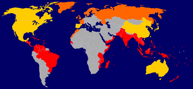
A map of tropical cyclone affected areas. Based off Image:BlankMap-World-v5.png and overlaid with Image:Ocean-layer BlankMap-World.png. Information based mainly off Image:Global tropical cyclone tracks.jpg. Fully-tropical cyclones have affected these nations/territories.
Both fully-tropical cyclones, as well as extratropical remnants of tropical cyclones, have affected these areas.
Extratropical remnants of tropical cyclones have affected these areas.
This is by no means a fully-complete map, and may contain errors. |
||||||||
| Ημερομηνία |
2006-09-29 Updated: 2006-09-30 Updated: 2006-12-23 Updated: 2007-04-09 |
||||||||
| Πηγή | Self-work | ||||||||
| Δημιουργός | User:NSLE-Chacor | ||||||||
| Άδεια (Επαναχρησιμοποίηση αυτού του αρχείου) |
|

Ιστορικό αρχείου
Κλικάρετε σε μια ημερομηνία/ώρα για να δείτε το αρχείο όπως εμφανιζόταν εκείνη τη στιγμή.
| Ώρα/Ημερομ. | Μικρογραφία | Διαστάσεις | Χρήστης | Σχόλια | |
|---|---|---|---|---|---|
| τελευταία | 16:08, 9 Απριλίου 2007 | | 1.347 × 624 (94 KB) | NSLE-Chacor | Background changed to blue, Panama back to red |
| 12:19, 23 Δεκεμβρίου 2006 |  | 1.347 × 624 (93 KB) | NSLE-Chacor | Further update using Image:Global tropical cyclone tracks.jpg - two countries changed to grey (unaffected), Senegal added in tropical | |
| 12:08, 23 Δεκεμβρίου 2006 |  | 1.347 × 624 (93 KB) | NSLE-Chacor | Fixed stray blues not changed in colour scheme change | |
| 12:06, 23 Δεκεμβρίου 2006 |  | 1.347 × 624 (93 KB) | NSLE-Chacor | update: Colour change, Mexico, Bahamas and Taiwan to both tropical and extratropical | |
| 05:04, 30 Σεπτεμβρίου 2006 |  | 1.347 × 624 (130 KB) | NSLE-Chacor | Update: Denmark changed to green (Faeroe Islands affected by w:Hurricane Faith while tropical); Australia changed to green (extratropical remnants recorded). | |
| 06:15, 29 Σεπτεμβρίου 2006 |  | 1.347 × 624 (130 KB) | NSLE-Chacor | {{Information |Description= A map of tropical cyclone affected areas. Based off Image:BlankMap-World-v5.png and overlaid with Image:Ocean-layer BlankMap-World.png. Aqua-coloured nations/territories indicate that fully-tropical cyclones have affe |
Συνδέσεις αρχείου
Τα παρακάτω λήμματα συνδέουν σε αυτό το αρχείο:
Καθολική χρήση αρχείου
Τα ακόλουθα άλλα wiki χρησιμοποιούν αυτό το αρχείο:
- Χρήση σε en.wikipedia.org
- Χρήση σε ml.wikipedia.org
- Χρήση σε pt.wikipedia.org