
Αρχείο:KYphysiography.jpg

Μέγεθος αυτής της προεπισκόπησης: 800 × 353 εικονοστοιχεία . Άλλες αναλύσεις: 320 × 141 εικονοστοιχεία | 824 × 364 εικονοστοιχεία.
Εικόνα σε υψηλότερη ανάλυση (824 × 364 εικονοστοιχεία, μέγεθος αρχείου: 159 KB, τύπος MIME: image/jpeg)
|
|
Αυτό το αρχείο και η περιγραφή του προέρχονται από το Wikimedia Commons. Οι πληροφορίες από την σελίδα περιγραφής του εκεί εμφανίζονται παρακάτω. |

|
This map image could be re-created using vector graphics as an SVG file. This has several advantages; see Commons:Media for cleanup for more information. If an SVG form of this image is available, please upload it and afterwards replace this template with
{{vector version available|new image name}}.
It is recommended to name the SVG file “KYphysiography.svg”—then the template Vector version available (or Vva) does not need the new image name parameter. |


Σύνοψη
| Περιγραφή |
English: I created this image using Wikipedia's map of Kentucky counties.
|
| Ημερομηνία | 1 Μαΐου 2007 (original upload date) |
| Πηγή | Transferred from en.wikipedia to Commons by byankno1. |
| Δημιουργός | Lamontacranston at Αγγλικά Βικιπαίδεια |
Αδειοδότηση
| Το έργο αυτό έχει απελευθερωθεί στην public domain από τον δημιουργό του, Lamontacranston at Αγγλικά Βικιπαίδεια. Αυτό ισχύει σε όλο τον κόσμο. Σε ορισμένες χώρες αυτό μπορεί να μην είναι νομικά εφικτό. Αν ναι: Lamontacranston Παραχωρώ σε οποιονδήποτε το δικαίωμα να χρησιμοποιήσει αυτό το έργο "για οποιονδήποτε σκοπό", χωρίς κανέναν όρο, εκτός και αν τέτοιοι όροι τίθενται από την νομοθεσία |
Καταγραφές ανεβασμάτων πρωτότυπου αρχείου
The original description page was here. All following user names refer to en.wikipedia.
- 2007-05-01 00:01 Lamontacranston 824×364× (162592 bytes) Bigger fonts. I created this image.
- 2007-04-30 23:54 Lamontacranston 824×364× (154693 bytes) Added text, improved edges, slightly lightened colors. I created the original.
- 2006-09-09 19:16 Lamontacranston 824×364× (55286 bytes) I created this image using Wikipedia's map of Kentucky counties.
Ιστορικό αρχείου
Κλικάρετε σε μια ημερομηνία/ώρα για να δείτε το αρχείο όπως εμφανιζόταν εκείνη τη στιγμή.
| Ώρα/Ημερομ. | Μικρογραφία | Διαστάσεις | Χρήστης | Σχόλια | |
|---|---|---|---|---|---|
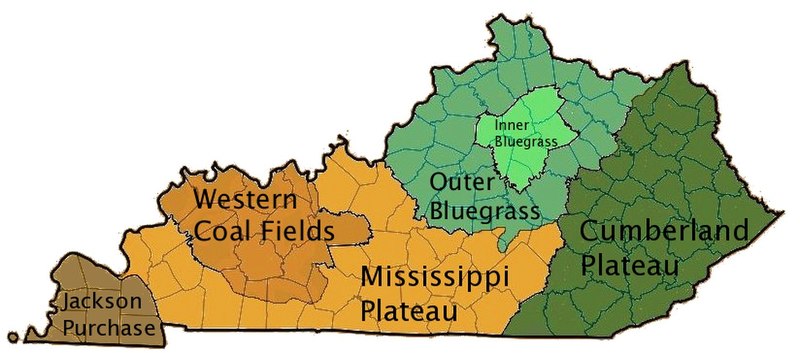
| τελευταία | 16:36, 18 Νοεμβρίου 2008 | | 824 × 364 (159 KB) | EpcotMagic | {{Information |Description={{en|I created this image using Wikipedia's map of Kentucky counties. *Dark green - Eastern Kentucky Coal fields (Cumberland Plateau) *Green - Outer Bluegrass *Light Green - Inner Bluegrass *Light Brown - Mississippi (Pennyroyal |
Συνδέσεις αρχείου
Τα παρακάτω λήμματα συνδέουν σε αυτό το αρχείο:
Καθολική χρήση αρχείου
Τα ακόλουθα άλλα wiki χρησιμοποιούν αυτό το αρχείο:
- Χρήση σε ar.wikipedia.org
- Χρήση σε de.wikipedia.org
- Χρήση σε en.wikipedia.org
- Χρήση σε es.wikipedia.org
- Χρήση σε fi.wikipedia.org
- Χρήση σε he.wikipedia.org
- Χρήση σε ia.wikipedia.org
- Χρήση σε id.wikipedia.org
- Χρήση σε it.wikipedia.org
- Χρήση σε ja.wikipedia.org
- Χρήση σε no.wikipedia.org
- Χρήση σε pt.wikipedia.org
- Χρήση σε sh.wikipedia.org
- Χρήση σε simple.wikipedia.org
- Χρήση σε sv.wikipedia.org
- Χρήση σε vi.wikipedia.org
- Χρήση σε zh.wikipedia.org