
Αρχείο:Europe mediterranean 1097.jpg

Εικόνα σε υψηλότερη ανάλυση (2.270 × 1.789 εικονοστοιχεία, μέγεθος αρχείου: 4,85 MB, τύπος MIME: image/jpeg)
|
|
Αυτό το αρχείο και η περιγραφή του προέρχονται από το Wikimedia Commons. Οι πληροφορίες από την σελίδα περιγραφής του εκεί εμφανίζονται παρακάτω. |


|
This map has been uploaded by Electionworld from en.wikipedia.org to enable the |
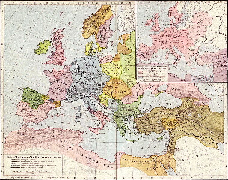
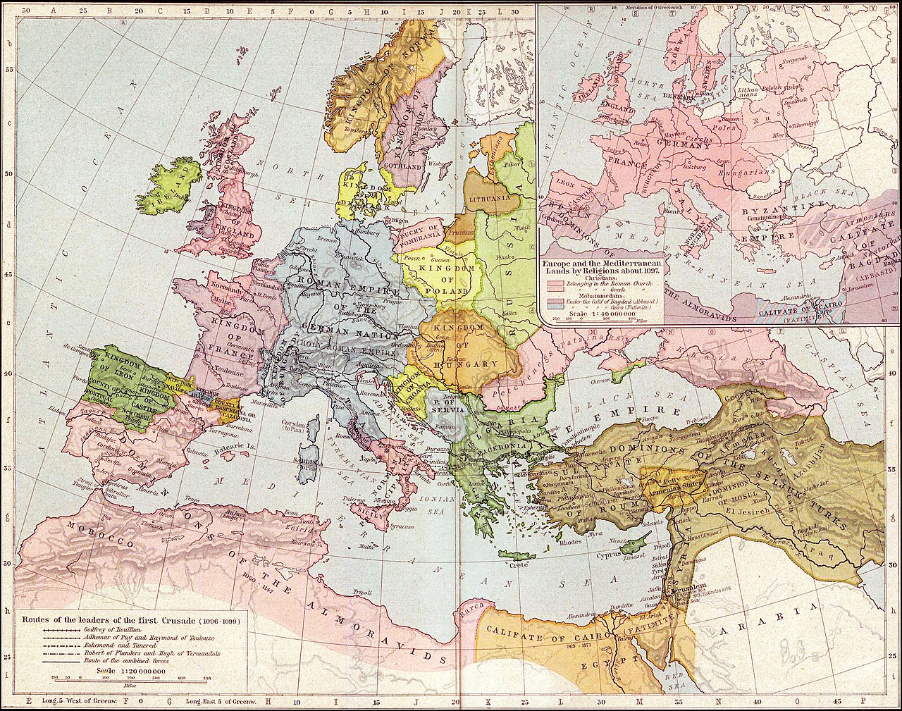
Map of Mediterranean and European lands anout 1097. Map from: Historical Atlas by William Shepherd (1923-26), in Public Domain
|
Αυτό το έργο είναι κοινό κτήμα στη χώρα προέλευσής του και άλλες χώρες και περιοχές όπου η διάρκεια πνευματικών δικαιωμάτων είναι όσο η ζωή του δημιουργού και μέχρι 70 χρόνια μετά ή λιγότερο.
| |
| Αυτό το αρχείο έχει χαρακτηριστεί ως απαλλαγμένο από γνωστούς περιορισμούς βάσει της νομοθεσίας περί πνευματικής ιδιοκτησίας, περιλαμβανομένων όλων των συναφών και συγγενικών δικαιωμάτων. | |
.jpg)
Ιστορικό αρχείου
Κλικάρετε σε μια ημερομηνία/ώρα για να δείτε το αρχείο όπως εμφανιζόταν εκείνη τη στιγμή.
| Ώρα/Ημερομ. | Μικρογραφία | Διαστάσεις | Χρήστης | Σχόλια | |
|---|---|---|---|---|---|
| τελευταία | 03:36, 27 Σεπτεμβρίου 2021 | | 2.270 × 1.789 (4,85 MB) | GPinkerton | Reverted to version as of 01:31, 30 January 2007 (UTC) do not alter historical maps! |
| 18:03, 26 Ιουνίου 2020 |  | 2.270 × 1.789 (4,84 MB) | Claude Zygiel | Map of Europe and Mediterranean lands about 1097: Byzantine Empire had not been completely excluded from Anatolia (Mantzikert, 1071) and the lower Danube was not pagan even if Pechenegs were Tengrists. | |
| 01:31, 30 Ιανουαρίου 2007 |  | 2.270 × 1.789 (4,85 MB) | Patrickneil | {{ew|en|Wirya}} Map of Kurdistan and Mediterranean and European lands anout 1097. Map from: [http://www.lib.utexas.edu/maps/historical/shepherd/europe_mediterranean_1097.jpg], in Public Domain {{PD-old}} | |
| 14:59, 3 Δεκεμβρίου 2006 |  | 2.314 × 1.805 (725 KB) | Electionworld | {{ew|en|Wirya}} Map of Kurdistan and Mediterranean and European lands anout 1097. Map from: [http://www.lib.utexas.edu/maps/historical/shepherd/europe_mediterranean_1097.jpg], in Public Domain {{PD}} |
Συνδέσεις αρχείου
Τα παρακάτω λήμματα συνδέουν σε αυτό το αρχείο:
Καθολική χρήση αρχείου
Τα ακόλουθα άλλα wiki χρησιμοποιούν αυτό το αρχείο:
- Χρήση σε ast.wikipedia.org
- Χρήση σε ba.wikipedia.org
- Χρήση σε bg.wikipedia.org
- Χρήση σε ce.wikipedia.org
- Χρήση σε ckb.wikipedia.org
- Χρήση σε de.wikipedia.org
- Χρήση σε en.wikipedia.org
- Χρήση σε es.wikipedia.org
- Χρήση σε et.wikipedia.org
- Χρήση σε fa.wikipedia.org
- Χρήση σε fr.wikipedia.org
- Χρήση σε gl.wikipedia.org
- Χρήση σε hu.wikipedia.org
- Χρήση σε id.wikipedia.org
- Χρήση σε it.wikipedia.org
- Χρήση σε ms.wikipedia.org
- Χρήση σε nn.wikipedia.org
- Χρήση σε pnb.wikipedia.org
- Χρήση σε pt.wikipedia.org
- Χρήση σε ro.wikipedia.org
- Χρήση σε ru.wikipedia.org
Δείτε περισσότερη καθολική χρήση αυτού του αρχείου.