
Αρχείο:EFS highres STS091 STS091-731-32.JPG

Εικόνα σε υψηλότερη ανάλυση (4.078 × 4.078 εικονοστοιχεία, μέγεθος αρχείου: 15,84 MB, τύπος MIME: image/jpeg)
|
|
Αυτό το αρχείο και η περιγραφή του προέρχονται από το Wikimedia Commons. Οι πληροφορίες από την σελίδα περιγραφής του εκεί εμφανίζονται παρακάτω. |
Σύνοψη
| Περιγραφή |
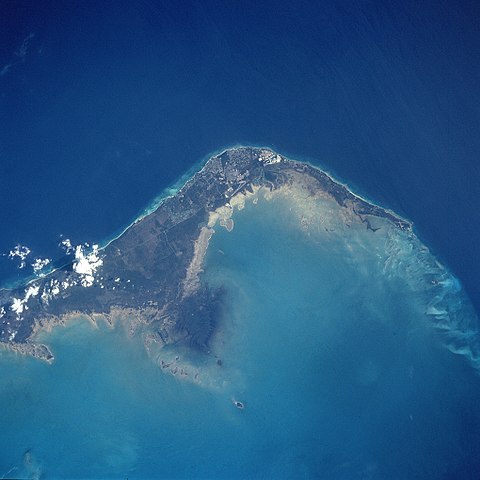
English: STS091-731-032 Grand Bahama Island, Freeport and Lucaya, Bahamas June 1998
The small cities of Freeport and Lucaya, on the southwest portion of Grand Bahama Island (slightly above the center of the view), can be seen in this southwest-looking view. Freeport and Lucaya are the Bahamas second largest metropolitan area. Nearly 50 years ago, neither city even existed. The Freeport and Lucaya region is a free trade zone area. Besides numerous tourist resorts and recreational areas, Freeport and Lucaya’s other activities include oil refining, cement production, distilling of liquor, and making of pharmaceutical products. As with the other islands of the Bahamas, Grand Bahama is composed largely of calcareous materials derived from marine organisms. A karst landscape covers many of the higher elevations on the island. Grand Bahama Island is 96 miles (154 km) long and 17 miles (27 km) at its widest point. The darker blue, deep waters of the Atlantic Ocean are visible in the upper portion of the view. The lighter blue, shallow waters covering the Bahama Shelf are discernible in the bottom portion of the view. Images: All Available Images Low-Resolution 277k Mission: STS091 Roll - Frame: 731 - 32 Geographical Name: BAHAMAS Features: FREEPORT, GRAND BAHAMA I. Center Lat x Lon: 26.5N x 78.5W Film Exposure: N N=Normal exposure, U=Under exposed, O=Over exposed, F=out of Focus Percentage of Cloud Cover-CLDP: 5 Camera: HB Camera Tilt: 16 LO=Low Oblique, HO=High Oblique, NV=Near Vertical Camera Focal Length: 250 Nadir to Photo Center Direction: NW The direction from the nadir to the center point, N=North, S=South, E=East, W=West Stereo?: Y Y=Yes there is an adjacent picture of the same area, N=No there isn't Orbit Number: 78 Date: 19980607 YYYYMMDD Time: 195254 GMT HHMMSS Nadir Lat: 25.8N Latitude of suborbital point of spacecraft Nadir Lon: 77.9W Longitude of suborbital point of spacecraft Sun Azimuth: 274 Clockwise angle in degrees from north to the sun measured at the nadir point Space Craft Altitude: 198 nautical miles Sun Elevation: 53 Angle in degrees between the horizon and the sun, measured at the nadir point Land Views: ISLAND, COAST Water Views: OCEAN Atmosphere Views: Man Made Views: URBAN AREA, AIRPORT City Views: FREEPORT |
| Ημερομηνία | |
| Πηγή |
http://eol.jsc.nasa.gov/sseop/EFS/photoinfo.pl?PHOTO=STS091-731-32 http://eol.jsc.nasa.gov/scripts/sseop/LargeImageAccess.pl?directory=EFS/highres/STS091&filename=STS091-731-32.JPG&filesize=16606733 |
| Δημιουργός | Image Science and Analysis Laboratory, NASA-Johnson Space Center |
This image or video was catalogued by one of the centers of the United States National Aeronautics and Space Administration (NASA) under Photo ID: STS091-731-32. This tag does not indicate the copyright status of the attached work. A normal copyright tag is still required. See Commons:Licensing. Other languages:
|
Αδειοδότηση
| Αυτό το αρχείο είναι κοινό κτήμα γιατί δημιουργήθηκε από την NASA. Η πολιτική πνευματικής ιδιοκτησίας της NASA δηλώνει ότι «Το υλικό της NASA δεν προστατεύεται από copyright εκτός αν αναφέρεται». (Σελίδα με την πολιτική πνευματικής ιδιοκτησίας της NASA ή Πολιτική Χρήσης Εικόνων του JPL). | ||
 |
Προσοχή:
|
Ιστορικό αρχείου
Κλικάρετε σε μια ημερομηνία/ώρα για να δείτε το αρχείο όπως εμφανιζόταν εκείνη τη στιγμή.
| Ώρα/Ημερομ. | Μικρογραφία | Διαστάσεις | Χρήστης | Σχόλια | |
|---|---|---|---|---|---|
| τελευταία | 08:26, 14 Απριλίου 2011 | | 4.078 × 4.078 (15,84 MB) | Andkore | {{Information |Description ={{en|1=STS091-731-032 Grand Bahama Island, Freeport and Lucaya, Bahamas June 1998 The small cities of Freeport and Lucaya, on the southwest portion of Grand Bahama Island (slightly above the center of the view), can be seen |
Συνδέσεις αρχείου
Τα παρακάτω λήμματα συνδέουν σε αυτό το αρχείο:
Καθολική χρήση αρχείου
Τα ακόλουθα άλλα wiki χρησιμοποιούν αυτό το αρχείο:
- Χρήση σε en.wikipedia.org
- Χρήση σε es.wikipedia.org
- Χρήση σε eu.wikipedia.org
- Χρήση σε fa.wikipedia.org
- Χρήση σε fo.wikipedia.org
- Χρήση σε fr.wikipedia.org
- Χρήση σε ja.wikipedia.org
- Χρήση σε ka.wikipedia.org
- Χρήση σε nl.wikipedia.org
- Χρήση σε pt.wikipedia.org
- Χρήση σε sr.wikipedia.org
- Χρήση σε tr.wikipedia.org
- Χρήση σε zh.wikipedia.org