
Αρχείο:Civitas Londinium or The Agas Map of London.jpg

Μέγεθος αυτής της προεπισκόπησης: 800 × 338 εικονοστοιχεία . Άλλες αναλύσεις: 320 × 135 εικονοστοιχεία | 640 × 271 εικονοστοιχεία | 1.024 × 433 εικονοστοιχεία | 1.280 × 541 εικονοστοιχεία | 4.730 × 2.000 εικονοστοιχεία.
Εικόνα σε υψηλότερη ανάλυση (4.730 × 2.000 εικονοστοιχεία, μέγεθος αρχείου: 4,08 MB, τύπος MIME: image/jpeg)
|
|
Αυτό το αρχείο και η περιγραφή του προέρχονται από το Wikimedia Commons. Οι πληροφορίες από την σελίδα περιγραφής του εκεί εμφανίζονται παρακάτω. |
Σύνοψη
| Περιγραφή |
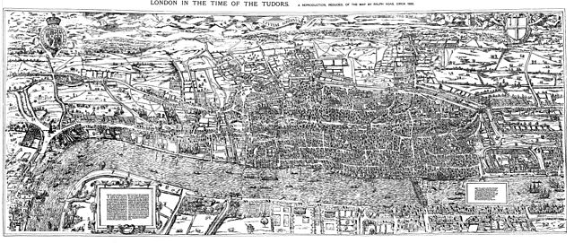
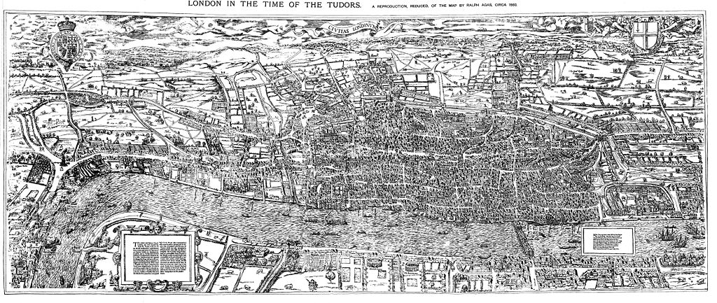
English: The earliest proper map (as opposed to panorama) of London known. Attributed to Ralph Agas, and probably surveyed between 1570 and 1605. The original was 6 foot 0.5 inches long by 2 feet 4.5 inches wide. This much reduced image is a scan of a copy of a lithograph of a copy, was itself badly repaired with sellotape and has had to be "restored"; so is hardly a truly faithful representation of the original, but few good copies exist and no other detailed public domain images are known. |
| Ημερομηνία | |
| Πηγή | Maps of Old London, London, Adam and Charles Black, 1908. Scanned & corrected Mike Calder. |
| Δημιουργός | Mike Calder, image of Civitas Londinium, Agas' Map of London, c. 1570-1605 |
| άλλες εκδόσεις | Derivative works of this file: Covent Garden from the Ralph Agas 1572 map of London.jpg |
Αδειοδότηση
|
Αυτό το έργο είναι κοινό κτήμα στη χώρα προέλευσής του και άλλες χώρες και περιοχές όπου η διάρκεια πνευματικών δικαιωμάτων είναι όσο η ζωή του δημιουργού και μέχρι 100 χρόνια μετά ή λιγότερο. | |
| Αυτό το αρχείο έχει χαρακτηριστεί ως απαλλαγμένο από γνωστούς περιορισμούς βάσει της νομοθεσίας περί πνευματικής ιδιοκτησίας, περιλαμβανομένων όλων των συναφών και συγγενικών δικαιωμάτων. | |
Ιστορικό αρχείου
Κλικάρετε σε μια ημερομηνία/ώρα για να δείτε το αρχείο όπως εμφανιζόταν εκείνη τη στιγμή.
| Ώρα/Ημερομ. | Μικρογραφία | Διαστάσεις | Χρήστης | Σχόλια | |
|---|---|---|---|---|---|
| τελευταία | 18:59, 14 Αυγούστου 2009 | | 4.730 × 2.000 (4,08 MB) | MikeCalder | {{Information |Description={{en|1=The earliest proper map (as opposed to panorama) of London known. Attributed to Ralph Agas, and probably surveyed between 1570 and 1605. The original was 6 foot 0.5 inches long by 2 feet 4.5 inches wide. This much reduc |
Συνδέσεις αρχείου
Τα παρακάτω λήμματα συνδέουν σε αυτό το αρχείο:
Καθολική χρήση αρχείου
Τα ακόλουθα άλλα wiki χρησιμοποιούν αυτό το αρχείο:
- Χρήση σε af.wikipedia.org
- Χρήση σε ar.wikipedia.org
- Χρήση σε avk.wikipedia.org
- Χρήση σε azb.wikipedia.org
- Χρήση σε de.wikipedia.org
- Χρήση σε en.wikipedia.org
- Χρήση σε es.wikipedia.org
- Χρήση σε fa.wikipedia.org
- Χρήση σε hy.wikipedia.org
- Χρήση σε it.wikipedia.org
- Χρήση σε ja.wikipedia.org
- Χρήση σε ko.wikipedia.org
- Χρήση σε la.wikipedia.org
- Χρήση σε pt.wikipedia.org
- Χρήση σε ro.wikipedia.org
- Χρήση σε ru.wikipedia.org
- Χρήση σε simple.wikipedia.org
- Χρήση σε sl.wikipedia.org
- Χρήση σε tr.wikipedia.org
- Χρήση σε uk.wikipedia.org
- Χρήση σε zh.wikipedia.org