
Αρχείο:Cantinomap redsea persiangulf.jpg

Εικόνα σε υψηλότερη ανάλυση (666 × 605 εικονοστοιχεία, μέγεθος αρχείου: 318 KB, τύπος MIME: image/jpeg)
|
|
Αυτό το αρχείο και η περιγραφή του προέρχονται από το Wikimedia Commons. Οι πληροφορίες από την σελίδα περιγραφής του εκεί εμφανίζονται παρακάτω. |
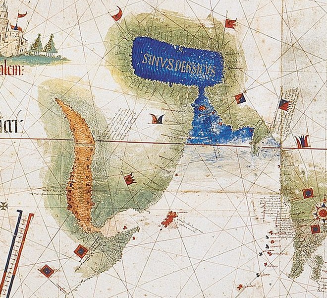
| Περιγραφή | Enlarged detail showing Red Sea and Persian Gulf as viewed in 1502 in the Cantino World Map. Most important manuscript map surviving from the early Age of Discovery, the Cantino World Map is named for Alberto Cantino, an Italian diplomatic agent in Lisbon who obtained it in 1502 for the Duke of Ferrara. It incorporates extensive new geographical information based on four series of voyages: Columbus to the Caribbean, Pedro Álvarez Cabral to Brazil, Vasco de Gama followed by Cabral to eastern Africa and India, and the brothers Corte-Real to Greenland and Newfoundland. Except for Columbus, all had sailed under the Portuguese flag. |
| Ημερομηνία | (UTC) |
| Πηγή | |
| Δημιουργός |
|
| Αυτή είναι μία ρετουσαρισμένη εικόνα, που σημαίνει ότι έχει μεταβληθεί ψηφιακά από την αρχική της έκδοση. Τροποποιήσεις: zoom in of Cantino map: the Red sea and Persian Golf. Η πρωτότυπη μπορεί να βρεθεί εδώ: CantinoPlanisphere.png.
|
|
Το δισδιάστατο έργο τέχνης που απεικονίζεται σε αυτή την εικόνα είναι κοινό κτήμα (δηλαδή δεν καλύπτεται από πνευματικά δικαιώματα) παγκόσμια, εξαιτίας της ημερομηνίας θανάτου του δημιουργού του, ή της ημερομηνίας της έκδοσής του.
Συνεπώς και αυτή η αναπαραγωγή του έργου είναι κοινό κτήμα (αυτό ισχύει για αναπαραγωγές που δημιουργήθηκαν στις Ηνωμένες Πολιτείες, την Γερμανία, και πολλές άλλες χώρες).
| ||||
Καταγραφές ανεβασμάτων πρωτότυπου αρχείου
This image is a derivative work of the following images:
- File:CantinoPlanisphere.png licensed with PD-Art, PD-old
- 2007-07-01T05:35:29Z Tdmthomas 3528x1656 (12458523 Bytes) {{Information |Description=The most important manuscript map surviving from the early Age of Discovery, the Cantino World Map is named for Alberto Cantino, an Italian diplomatic agent in Lisbon who obtained it in 1502 for the
Uploaded with derivativeFX
Ιστορικό αρχείου
Κλικάρετε σε μια ημερομηνία/ώρα για να δείτε το αρχείο όπως εμφανιζόταν εκείνη τη στιγμή.
| Ώρα/Ημερομ. | Μικρογραφία | Διαστάσεις | Χρήστης | Σχόλια | |
|---|---|---|---|---|---|
| τελευταία | 13:39, 12 Δεκεμβρίου 2009 | | 666 × 605 (318 KB) | Uxbona | {{Information |Description= Enlarged detail showing Red Sea and Persian Gulf as viewed in 1502 in the Cantino World Map. Most important manuscript map surviving from the early Age of Discovery, the Cantino World Map is named for Alberto Cantino, an Italia |
Συνδέσεις αρχείου
Τα παρακάτω λήμματα συνδέουν σε αυτό το αρχείο:
Καθολική χρήση αρχείου
Τα ακόλουθα άλλα wiki χρησιμοποιούν αυτό το αρχείο:
- Χρήση σε ar.wikipedia.org
- Χρήση σε ca.wikipedia.org
- Χρήση σε ckb.wikipedia.org
- Χρήση σε de.wikipedia.org
- Χρήση σε en.wikipedia.org
- Χρήση σε es.wikipedia.org
- Χρήση σε fa.wikipedia.org
- Χρήση σε fr.wikipedia.org
- Χρήση σε it.wikipedia.org
- Χρήση σε mk.wikipedia.org
- Χρήση σε ms.wikipedia.org
- Χρήση σε pt.wikipedia.org
- Χρήση σε ru.wikipedia.org
- Χρήση σε uk.wikipedia.org
- Χρήση σε yi.wikipedia.org