
Αρχείο:Butaritari Map.jpg

Εικόνα σε υψηλότερη ανάλυση (7.864 × 6.982 εικονοστοιχεία, μέγεθος αρχείου: 1,32 MB, τύπος MIME: image/jpeg)
|
|
Αυτό το αρχείο και η περιγραφή του προέρχονται από το Wikimedia Commons. Οι πληροφορίες από την σελίδα περιγραφής του εκεί εμφανίζονται παρακάτω. |
| Προσοχή | Μερικοί φυλλομετρητές ίσως αντιμετωπίσουν πρόβλημα με την απεικόνιση αυτής της εικόνας σε πλήρη ανάλυση: Αυτή η εικόνα έχει πολύ μεγάλο αριθμό πίξελς και μπορεί είτε να μη φορτωθεί κανονικά είτε ο φυλλομετρητής να κολλήσει. |
|---|
Σύνοψη
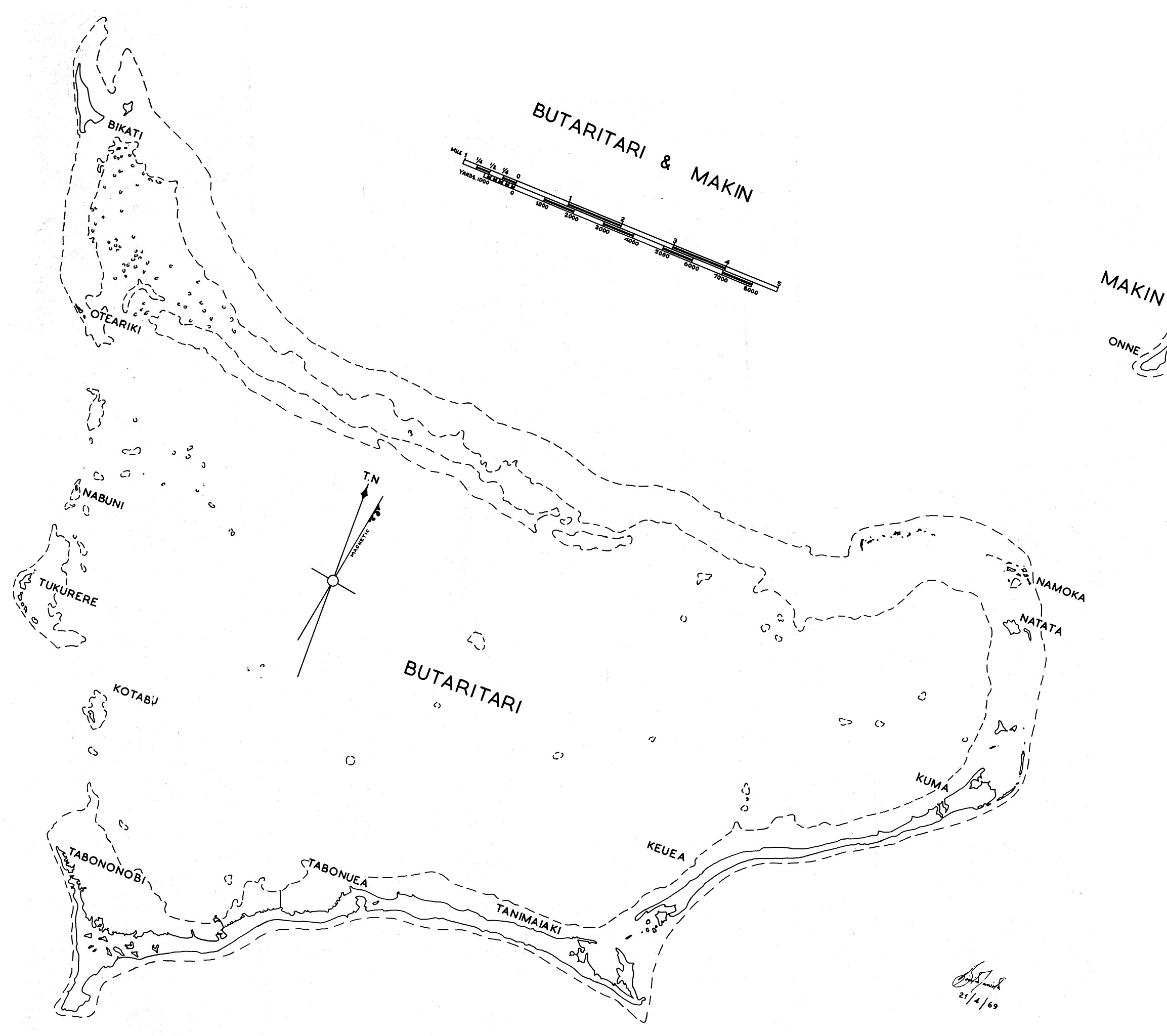
Government map (some maps in the series include the following: "Compiled by Lands and Surveys, Betio, Tarawa") with inscription "[signature 21/4/1969". Original obtained either directly from GEIDA of from a U.S. Government source (USACOE) as a blueline printing sometime in the 1970s. I believe these maps were produced for government use by the Gilbert Islands Colony. I have scanned and slightly altered the original (1/50,000 scale). Makin portion was partly lost in storage. Orientation as printed. - Marshman 01:22, 29 November 2005 (UTC)
Αδειοδότηση
This work is in the public domain in the United States because it is a work prepared by an officer or employee of the United States Government as part of that person’s official duties under the terms of Title 17, Chapter 1, Section 105 of the US Code.
Note: This only applies to original works of the Federal Government and not to the work of any individual U.S. state, territory, commonwealth, county, municipality, or any other subdivision. This template also does not apply to postage stamp designs published by the United States Postal Service since 1978. (See § 313.6(C)(1) of Compendium of U.S. Copyright Office Practices). It also does not apply to certain US coins; see The US Mint Terms of Use.
|
 | |
| Αυτό το αρχείο έχει χαρακτηριστεί ως απαλλαγμένο από γνωστούς περιορισμούς βάσει της νομοθεσίας περί πνευματικής ιδιοκτησίας, περιλαμβανομένων όλων των συναφών και συγγενικών δικαιωμάτων. | ||
Ιστορικό αρχείου
Κλικάρετε σε μια ημερομηνία/ώρα για να δείτε το αρχείο όπως εμφανιζόταν εκείνη τη στιγμή.
| Ώρα/Ημερομ. | Μικρογραφία | Διαστάσεις | Χρήστης | Σχόλια | |
|---|---|---|---|---|---|
| τελευταία | 01:19, 29 Νοεμβρίου 2005 | | 7.864 × 6.982 (1,32 MB) | Marshman~commonswiki | Same as previous Kiribati maps |
Συνδέσεις αρχείου
Τα παρακάτω λήμματα συνδέουν σε αυτό το αρχείο:
Καθολική χρήση αρχείου
Τα ακόλουθα άλλα wiki χρησιμοποιούν αυτό το αρχείο:
- Χρήση σε de.wikipedia.org
- Χρήση σε en.wikipedia.org
- Χρήση σε gl.wikipedia.org
- Χρήση σε he.wikipedia.org
- Χρήση σε hu.wikipedia.org
- Χρήση σε ja.wikipedia.org
- Χρήση σε mk.wikipedia.org
- Χρήση σε pl.wikipedia.org
- Χρήση σε ru.wikipedia.org
- Χρήση σε www.wikidata.org