
Αρχείο:Bastogne Map December 19-23 1944.jpg
Μέγεθος αυτής της προεπισκόπησης: 800 × 477 εικονοστοιχεία . Άλλες αναλύσεις: 320 × 191 εικονοστοιχεία | 640 × 381 εικονοστοιχεία | 1.024 × 610 εικονοστοιχεία | 1.556 × 927 εικονοστοιχεία.
Εικόνα σε υψηλότερη ανάλυση (1.556 × 927 εικονοστοιχεία, μέγεθος αρχείου: 1,19 MB, τύπος MIME: image/jpeg)
|
|
Αυτό το αρχείο και η περιγραφή του προέρχονται από το Wikimedia Commons. Οι πληροφορίες από την σελίδα περιγραφής του εκεί εμφανίζονται παρακάτω. |
Σύνοψη
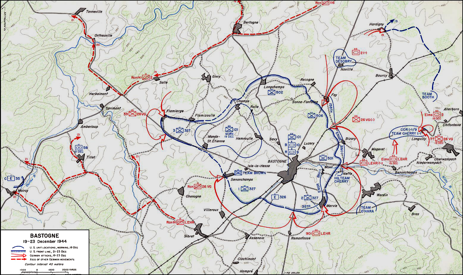
| Περιγραφή | ||||||||||
| Ημερομηνία | ||||||||||
| Πηγή | United States Army Center of Military History | |||||||||
| Δημιουργός | ||||||||||
| Geotemporal data | ||||||||||
| Ημερομηνία που απεικονίζεται | από 19 Δεκεμβρίου 1944 έως 23 Δεκεμβρίου 1944 | |||||||||
| Map location | Μπαστόν | |||||||||
| Heading |
 |
|||||||||
| Bounding box |
|
|||||||||
| Georeferencing | ||||||||||

|
This military map image could be re-created using vector graphics as an SVG file. This has several advantages; see Commons:Media for cleanup for more information. If an SVG form of this image is available, please upload it and afterwards replace this template with
{{vector version available|new image name}}.
It is recommended to name the SVG file “Bastogne Map December 19-23 1944.svg”—then the template Vector version available (or Vva) does not need the new image name parameter. |


Αδειοδότηση
| This image is in the public domain because it contains materials that originally came from the United States Army Center of Military History, subject to the following qualification.
Note: The images of all badges, insignia, decorations and medals on the "CMH Online" web site are produced by the United States Army Institute of Heraldry and protected by Title 18, United States Code, Section 704 and the Code of Federal Regulations (32 CFR, Part 507). Permission to use these images for commercial purposes must be obtained from The Institute of Heraldry prior to their use. |

|
Ιστορικό αρχείου
Κλικάρετε σε μια ημερομηνία/ώρα για να δείτε το αρχείο όπως εμφανιζόταν εκείνη τη στιγμή.
| Ώρα/Ημερομ. | Μικρογραφία | Διαστάσεις | Χρήστης | Σχόλια | |
|---|---|---|---|---|---|
| τελευταία | 04:59, 4 Νοεμβρίου 2006 | | 1.556 × 927 (1,19 MB) | CORNELIUSSEON | {{Information |Description=Bastogne, Belgium Map; december 19-23, 1944. |Source=US Army Center for Military History |Date=December 19-23, 1944 |Author= |Permission={{PD-USGov-Military-Army-USACMH}} – US Army Center for Military History |other_versions= |
Συνδέσεις αρχείου
Τα παρακάτω λήμματα συνδέουν σε αυτό το αρχείο:
Καθολική χρήση αρχείου
Τα ακόλουθα άλλα wiki χρησιμοποιούν αυτό το αρχείο:
- Χρήση σε ar.wikipedia.org
- Χρήση σε ca.wikipedia.org
- Χρήση σε de.wikipedia.org
- Χρήση σε en.wikipedia.org
- Χρήση σε en.wikisource.org
- Χρήση σε es.wikipedia.org
- Χρήση σε he.wikipedia.org
- Χρήση σε it.wikipedia.org
- Χρήση σε ja.wikipedia.org
- Χρήση σε nl.wikipedia.org
- Χρήση σε ru.wikipedia.org
- Χρήση σε sl.wikipedia.org
- Χρήση σε ta.wikipedia.org
- Χρήση σε tr.wikipedia.org
- Χρήση σε www.wikidata.org
- Χρήση σε zh.wikipedia.org