
Αρχείο:WV plateau.jpg

Εικόνα σε υψηλότερη ανάλυση (800 × 784 εικονοστοιχεία, μέγεθος αρχείου: 472 KB, τύπος MIME: image/jpeg)
|
|
Αυτό το αρχείο και η περιγραφή του προέρχονται από το Wikimedia Commons. Οι πληροφορίες από την σελίδα περιγραφής του εκεί εμφανίζονται παρακάτω. |
Transferred from en.wikipedia to Commons by Maksim.
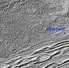
Relief Map: Cumberland Plateau, West Virginia and "Ridge and Valley" region of Virginia
Image is Shaded Relief Imagery, derived from the US Geological Survey National Elevation Dataset, modified by Pollinator. USGS-authored or produced data and information are in the public domain.
(Point of reference: Bluefield, West Virginia is on the Virginia/West Virginia border)
On the southeastern portion of this map is the folded Appalachians of Virginia, also known as the Ridge-and-valley Appalachians, which are the roots of true ancient mountains, uplifted once again, with the harder rock layers forming ridges and the more erodable rocks becoming valleys.
A major fault line runs from southwest to northeast dividing the folded mountains from the Cumberland Plateau of West Virginia, a dissected plateau that forms the majority of the image. This area of sedimentary rock (including many coal) veins is, geologically speaking, not true mountains, but merely was uplifted and eroded. Note that the area is actually more rugged than the folded mountains, though not as high.
This image is in the public domain in the United States because it only contains materials that originally came from the United States Geological Survey, an agency of the United States Department of the Interior. For more information, see the official USGS copyright policy.
|
| date/time | username | edit summary |
|---|---|---|
| 01:20, 12 February 2005 | en:User:RedWolf | ({{PD-USGov-Interior-USGS}}) |
| 06:23, 8 November 2004 | en:User:SimonP | |
| 20:08, 21 August 2004 | en:User:Pollinator | (tweak and wikify) |
| 19:55, 21 August 2004 | en:User:Pollinator | (public domain) |
| 19:52, 21 August 2004 | en:User:Pollinator | (link repair) |
| 19:50, 21 August 2004 | en:User:Pollinator | (Photo caption) |
| 19:38, 21 August 2004 | en:User:Pollinator | (Relief Map: Cumberland Plateau, West Virginia and "Ridge and Valley" region of Virginia) |
Καταγραφές ανεβασμάτων πρωτότυπου αρχείου
Legend: (cur) = this is the current file, (del) = delete this old version, (rev) = revert to this old version.
Click on date to download the file or see the image uploaded on that date.
- (del) (cur) 19:38, 21 August 2004 . . en:User:Pollinator Pollinator ( en:User_talk:Pollinator Talk) . . 800x784 (483656 bytes) (Relief Map: Cumberland Plateau, West Virginia and "Ridge and Valley" region of Virginia)
Ιστορικό αρχείου
Κλικάρετε σε μια ημερομηνία/ώρα για να δείτε το αρχείο όπως εμφανιζόταν εκείνη τη στιγμή.
| Ώρα/Ημερομ. | Μικρογραφία | Διαστάσεις | Χρήστης | Σχόλια | |
|---|---|---|---|---|---|
| τελευταία | 18:47, 5 Φεβρουαρίου 2006 | | 800 × 784 (472 KB) | Maksim | La bildo estas kopiita de wikipedia:en. La originala priskribo estas: Relief Map: Cumberland Plateau, West Virginia and "Ridge and Valley" region of Virginia Image is Shaded Relief Imagery, derived from the US Geological Survey National Elevation Datase |
Συνδέσεις αρχείου
Δεν υπάρχουν σελίδες που συνδέουν σε αυτό το αρχείο.
Καθολική χρήση αρχείου
Τα ακόλουθα άλλα wiki χρησιμοποιούν αυτό το αρχείο:
- Χρήση σε ca.wikipedia.org
- Χρήση σε da.wikipedia.org
- Χρήση σε en.wikipedia.org
- Χρήση σε eo.wikipedia.org
- Χρήση σε es.wikipedia.org
- Χρήση σε it.wikipedia.org
- Χρήση σε ja.wikipedia.org
- Χρήση σε nn.wikipedia.org
- Χρήση σε pt.wikipedia.org