
Αρχείο:Spanish Empire.png
Εικόνα σε υψηλότερη ανάλυση (1.357 × 628 εικονοστοιχεία, μέγεθος αρχείου: 38 KB, τύπος MIME: image/png)
|
|
Αυτό το αρχείο και η περιγραφή του προέρχονται από το Wikimedia Commons. Οι πληροφορίες από την σελίδα περιγραφής του εκεί εμφανίζονται παρακάτω. |

== Σύνοψη == sijn is kaulo koel en voeg zijn snap ( stijnsnoeck12)
| Περιγραφή |
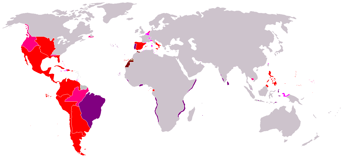
Map of the Spanish Empire from 295px. ΣύνοψηRedThe Spanish Empire as it stood under the en:House of Bourbon, reaching its peak in the early 1790s. Includes the en:Viceroyalty of New Spain, en:Viceroyalty of Peru, en:Viceroyalty of La Plata, en:Viceroyalty of New Granada, en:Audiencia of Chile, en:Cuba, en:Puerto Rico, en:Santo Domingo, the Louisiana colony, the Nootka colony, the en:Philippines, the satellite en:Kingdom of Naples and en:Duchy of Parma, and various island groups. Louisiana and New Orleans, which were never widely settled, were returned to France in 1800, the Nootka colony was abandoned in 1795; Spain ceded its claims to the en:Mississippi Territory to the United States in 1795 and en:Florida in 1819; en:New Spain became an independent en:Mexico in 1821. Spanish settlement did not reach the south of Argentina and Chile until the early en:19th century. By 1824, all of Spain's South American colonies had become independent republics. British economic rights in present-day en:Belize were established in the 18th century. The colony of en:British Honduras was not created until 1841, after the end of Spanish rule in the region. Most of Central America became independent in 1823 as the en:United Provinces of Central America. Cuba was granted independence and Puerto Rico was ceded to the United States after the en:Spanish-American War. PinkRegions of Spanish influence over various periods; disputed (i.e. Pacific Coast), unrecognized (i.e. en:Dutch Republic), or short-lived claims (i.e. Cambodia).
LavenderTerritories lost at or before the en:Peace of Utrecht in 1714. Spain lost Jamaica to England in the 1650s and Haiti to France in the en:17th century. Many smaller islands in the en:Bahamas and the en:Lesser Antilles were also settled by other Europeans during this period. Spain's territories in present-day France, such as en:Rousillon and the en:Franche-Comté, were conquered Louis XIV. Spain was stripped of her remaining European dominions in 1714. Spain reconquered some of her lost Italian possessions from the Austrians in the 18th century, placing Bourbon princes on the thrones of Parma, Naples, and Sicily. However, these were not incorporated again into the Spanish Crown. PurplePortuguese possessions ruled jointly under the Spanish sovereign, 1580-1640. BrownSpain's en:West African empire, including en:Spanish West Africa and en:Spanish Morocco. |
| Ημερομηνία | Commons upload by Kjetil r 10:47, 14 May 2006 (UTC) |
| Πηγή |
Originally from en.wikipedia; description page is (was) here
|
| Δημιουργός | Users Albrecht, Arthur Wellesley, XGustaX on en.wikipedia |
| Άδεια (Επαναχρησιμοποίηση αυτού του αρχείου) |
GFDL |
Αδειοδότηση

|
Παραχωρείται η άδεια προς αντιγραφή, διανομή και/ή τροποποίηση αυτού του εγγράφου υπό τους όρους της Άδειας Ελεύθερης Τεκμηρίωσης GNU, Έκδοση 1.2 ή οποιασδήποτε νεότερης έκδοσης δημοσιευμένης από το Ίδρυμα Ελεύθερου Λογισμικού· χωρίς Απαράλαχτους Τομείς, χωρίς Κείμενα Εξωφύλλου, και χωρίς Κείμενα Οπισθοφύλλου. Αντίγραφο της άδειας περιλαμβάνεται στην σελίδα με τίτλο GNU Free Documentation License. |
| Το αρχείο διανέμεται υπό την άδεια Creative Commons Αναφορά προέλευσης-Παρόμοια διανομή 3.0 Μη εισαγόμενη | ||
| ||
| Αυτή η ετικέτα άδειας χρήσης προστέθηκε στο αρχείο ως μέρους της αναθεώρησης της άδειας GFDL . |
See also


Ιστορικό αρχείου
Κλικάρετε σε μια ημερομηνία/ώρα για να δείτε το αρχείο όπως εμφανιζόταν εκείνη τη στιγμή.
| Ώρα/Ημερομ. | Μικρογραφία | Διαστάσεις | Χρήστης | Σχόλια | |
|---|---|---|---|---|---|
| τελευταία | 19:37, 18 Απριλίου 2008 | | 1.357 × 628 (38 KB) | Durero | Reverted to version as of 18:01, 16 April 2008 Talk |
| 18:58, 18 Απριλίου 2008 |  | 1.357 × 628 (37 KB) | Patstuart | Reverted to version as of 01:45, 15 April 2008 - Portugal was never part of the Spanish empire | |
| 18:01, 16 Απριλίου 2008 |  | 1.357 × 628 (38 KB) | Durero | Reverted to version as of 20:27, 14 January 2008 | |
| 01:45, 15 Απριλίου 2008 |  | 1.357 × 628 (37 KB) | The Ogre | Correcting erros - the Portuguese empire was never a part of the Spanish empire | |
| 20:27, 14 Ιανουαρίου 2008 |  | 1.357 × 628 (38 KB) | Durero | I include Sabah | |
| 09:19, 28 Σεπτεμβρίου 2006 |  | 1.357 × 628 (38 KB) | Koika | The Spanish area in Taiwan is ony NOT correct. | |
| 10:48, 14 Μαΐου 2006 |  | 1.357 × 628 (38 KB) | Kjetil r | ||
| 20:12, 11 Μαΐου 2006 |  | 1.357 × 628 (38 KB) | Kjetil r | {{Information| |Description= == Summary == Map of the en:Spanish Empire from Image:BlankMap-World.png. ==Description== *Red: all claimed Spanish territories(1492-1975), shown together simultaneously and at their maximum extent. Actual contol and set |
Συνδέσεις αρχείου
Δεν υπάρχουν σελίδες που συνδέουν σε αυτό το αρχείο.
Καθολική χρήση αρχείου
Τα ακόλουθα άλλα wiki χρησιμοποιούν αυτό το αρχείο:
- Χρήση σε an.wikipedia.org
- Χρήση σε ar.wikipedia.org
- Χρήση σε ast.wikipedia.org
- Χρήση σε cs.wikipedia.org
- Χρήση σε da.wikipedia.org
- Χρήση σε en.wikipedia.org
- Χρήση σε es.wikipedia.org
- Χρήση σε fr.wikipedia.org
- Χρήση σε gl.wikipedia.org
- Χρήση σε it.wikipedia.org
- Χρήση σε ka.wikipedia.org
- Χρήση σε sv.wikipedia.org
- Χρήση σε th.wikipedia.org
- Χρήση σε zh.wikipedia.org