
Αρχείο:Spratly Is since NalGeoMaps.png
Δεν διατίθεται υψηλότερη ανάλυση.
Spratly_Is_since_NalGeoMaps.png (330 × 354 εικονοστοιχεία, μέγεθος αρχείου: 31 KB, τύπος MIME: image/png)
|
|
Αυτό το αρχείο και η περιγραφή του προέρχονται από το Wikimedia Commons. Οι πληροφορίες από την σελίδα περιγραφής του εκεί εμφανίζονται παρακάτω. |

|
This locator map image could be re-created using vector graphics as an SVG file. This has several advantages; see Commons:Media for cleanup for more information. If an SVG form of this image is available, please upload it and afterwards replace this template with
{{vector version available|new image name}}.
It is recommended to name the SVG file “Spratly Is since NalGeoMaps.svg”—then the template Vector version available (or Vva) does not need the new image name parameter. |
Σύνοψη
| Περιγραφή |
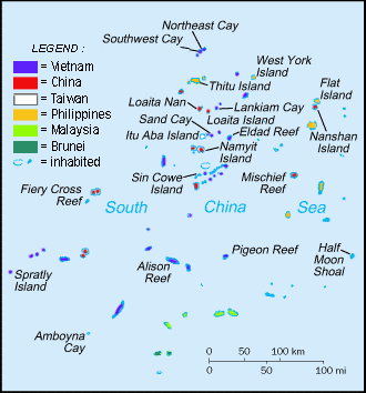
English: Spratly Islands military settlements
Français : Etablissements militaires dans l'archipel des Spratly
Tagalog: Sakop na lupa ng militar sa Pulo ng Kalayaan
中文(简体):南沙群岛的军事区
中文(繁體):南沙群島的軍事區 |
| Ημερομηνία | |
| Πηγή | Cartothèque Spiridon Manoliu |
| Δημιουργός | Spiridon Manoliu |
Αδειοδότηση
| Εγώ, ο κάτοχος των πνευματικών δικαιωμάτων αυτού του έργου, δημοσιεύω αυτό το έργο ως κοινό κτήμα. Αυτό ισχύει σε παγκόσμια κλίμακα. Σε ορισμένες χώρες αυτό μπορεί να μην είναι νομικά εφικτό. Αν ναι: Παραχωρώ σε οποιονδήποτε το δικαίωμα να χρησιμοποιήσει αυτό το έργο "για οποιονδήποτε σκοπό", χωρίς κανέναν όρο, εκτός και αν τέτοιοι όροι τίθενται από την νομοθεσία |
Ιστορικό αρχείου
Κλικάρετε σε μια ημερομηνία/ώρα για να δείτε το αρχείο όπως εμφανιζόταν εκείνη τη στιγμή.
| Ώρα/Ημερομ. | Μικρογραφία | Διαστάσεις | Χρήστης | Σχόλια | |
|---|---|---|---|---|---|
| τελευταία | 06:50, 12 Μαρτίου 2021 | | 330 × 354 (31 KB) | Mlgc1998 | typo |
| 11:46, 13 Απριλίου 2015 |  | 330 × 354 (18 KB) | RokerHRO | optipng -o7 -i0 → 42.83% decrease | |
| 14:05, 29 Μαρτίου 2009 |  | 330 × 354 (32 KB) | Spiridon Ion Cepleanu | {{Information |Description={{en|1=Spratley Islands military settlements}} {{fr|1=Etablissements militaires dans l'archipel des Spratly}} |Source=Cartothèque Spiridon Manoliu |Author=Spiridon Manoliu |Date=March 29, 2009 |Permission= |other_versions= }} |
Συνδέσεις αρχείου
Τα παρακάτω λήμματα συνδέουν σε αυτό το αρχείο:
Καθολική χρήση αρχείου
Τα ακόλουθα άλλα wiki χρησιμοποιούν αυτό το αρχείο:
- Χρήση σε bcl.wikipedia.org
- Χρήση σε br.wikipedia.org
- Χρήση σε cs.wikipedia.org
- Χρήση σε en.wikipedia.org
- Spratly Islands
- Exclusive economic zone
- Republic of Morac-Songhrati-Meads
- East Sea Campaign
- Philippines and the Spratly Islands
- Template:Spratly Islands
- Spratly Islands dispute
- Dangerous Ground (South China Sea)
- List of maritime features in the Spratly Islands
- List of airports in the Spratly Islands
- DK1 rigs
- Great Wall of Sand
- Χρήση σε en.wikinews.org
- Χρήση σε en.wikivoyage.org
- Χρήση σε fa.wikipedia.org
- Χρήση σε fi.wikipedia.org
- Χρήση σε fr.wikipedia.org
- Χρήση σε fr.wiktionary.org
- Χρήση σε gl.wikipedia.org
- Χρήση σε hi.wikipedia.org
- Χρήση σε id.wikipedia.org
- Χρήση σε io.wikipedia.org
- Χρήση σε ja.wikipedia.org
- Χρήση σε ko.wikipedia.org
- Χρήση σε no.wikipedia.org
- Χρήση σε pt.wikipedia.org
- Χρήση σε sv.wikipedia.org
- Χρήση σε th.wikipedia.org
- Χρήση σε tr.wikipedia.org
- Χρήση σε ug.wikipedia.org
- Χρήση σε vi.wikipedia.org